<< Our Photo Pages >> The Bridestones (Todmorden) - Natural Stone / Erratic / Other Natural Feature in England in Yorkshire (West)
Submitted by Anne T on Sunday, 17 February 2019 Page Views: 4640
Natural PlacesSite Name: The Bridestones (Todmorden) Alternative Name: Great Bride Stones (Todmorden)Country: England County: Yorkshire (West) Type: Natural Stone / Erratic / Other Natural Feature
Nearest Town: Todmorden
Map Ref: SD9332926737
Latitude: 53.736976N Longitude: 2.10261W
Condition:
| 5 | Perfect |
| 4 | Almost Perfect |
| 3 | Reasonable but with some damage |
| 2 | Ruined but still recognisable as an ancient site |
| 1 | Pretty much destroyed, possibly visible as crop marks |
| 0 | No data. |
| -1 | Completely destroyed |
| 5 | Superb |
| 4 | Good |
| 3 | Ordinary |
| 2 | Not Good |
| 1 | Awful |
| 0 | No data. |
| 5 | Can be driven to, probably with disabled access |
| 4 | Short walk on a footpath |
| 3 | Requiring a bit more of a walk |
| 2 | A long walk |
| 1 | In the middle of nowhere, a nightmare to find |
| 0 | No data. |
| 5 | co-ordinates taken by GPS or official recorded co-ordinates |
| 4 | co-ordinates scaled from a detailed map |
| 3 | co-ordinates scaled from a bad map |
| 2 | co-ordinates of the nearest village |
| 1 | co-ordinates of the nearest town |
| 0 | no data |
Be the first person to rate this site - see the 'Contribute!' box in the right hand menu.
Internal Links:
External Links:
I have visited· I would like to visit
Monocular71 would like to visit
ssituationist visited on 1st Jan 2023 - their rating: Cond: 5 Amb: 5 Access: 3
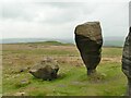
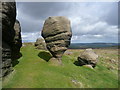
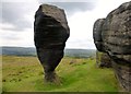
markj99 visited on 23rd Jan 2009 - their rating: Cond: 3 Amb: 5 Access: 4 There is a large lay-by at SD 93769 26809 on Eastwood Road from Todmordern. A path starts here leading to the Bridestones after c. 500 yards on a muddy path (stout footwear recommended). The Bridestones are far enough away from the road to give the unusual weathered stones an isolated special ambiance. The Bride Stone herself is the star attraction, the Groom Stone lies broken by her side.
Average ratings for this site from all visit loggers: Condition: 4 Ambience: 5 Access: 3.5
 (PID:227722)")
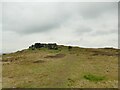
The Journal of Antiquities also includes an entry for The Bridestones, Near Todmorden, West Yorkshire, which adds these outcrops of millstone grit are half a mile long, and include a number of odd-shaped formations caused by weather-related erosion over the millennia. "The Bridestones are located about ½ a mile north-east of Eastwood Road – where a footpath runs across the often boggy moor to the outcrops. Another path connects the north-side of the outcrops from Kebs Road, and from just opposite Orchan House Farm at Fast Ends – it runs in a southerly direction across Bridestones Moor".
The Journal also includes photographs, a description and a list of reference sources for more information.
You may be viewing yesterday's version of this page. To see the most up to date information please register for a free account.
 (PID:227724)")
 (PID:227723)")
 (PID:227721)")
Do not use the above information on other web sites or publications without permission of the contributor.
Nearby Images from Geograph Britain and Ireland:
©2022(licence)
©2017(licence)
©2022(licence)
©2006(licence)
©2014(licence)
The above images may not be of the site on this page, they are loaded from Geograph.
Please Submit an Image of this site or go out and take one for us!
Click here to see more info for this site
Nearby sites
Key: Red: member's photo, Blue: 3rd party photo, Yellow: other image, Green: no photo - please go there and take one, Grey: site destroyed
Download sites to:
KML (Google Earth)
GPX (GPS waypoints)
CSV (Garmin/Navman)
CSV (Excel)
To unlock full downloads you need to sign up as a Contributory Member. Otherwise downloads are limited to 50 sites.
Turn off the page maps and other distractions
Nearby sites listing. In the following links * = Image available
406m SSW 210° Harley Wood Edge Rock Art (SD9312526386)
452m WSW 245° Golden Stones (Todmorden)* Rock Outcrop (SD9291926545)
648m WNW 293° Bridestones (above Cliviger Gorge)* Rock Art (SD9273026989)
864m S 170° Whirlaw Stones* Rock Art (SD9348125886)
1.2km WNW 302° Hawks Stones (Stansfield Moor) Natural Stone / Erratic / Other Natural Feature (SD92332735)
1.6km SE 143° The Frying Pan 1* Cairn (SD9433425426)
1.7km SE 138° The Frying Pan 2* Cairn (SD9445425507)
1.9km WNW 286° Mount Cross (Todmorden)* Ancient Cross (SD9146227284)
2.1km E 85° Staups Moor Standing Stones (SD95452692)
2.3km S 178° Holy Well (Todmorden)* Holy Well or Sacred Spring (SD9339324411)
2.8km ESE 108° Eastwood Old Hall* Rock Art (SD9602425866)
3.2km SSW 194° Stones monoliths, Todmorden* Standing Stones (SD92522359)
3.4km NE 38° New Edge Chalybeate (Colden)* Holy Well or Sacred Spring (SD9544729403)
3.7km NNE 16° Reap's Cross (Heptonstall Moor) Ancient Cross (SD9435830268)
4.0km NNE 30° Standing Stone Hill (Heptonstall)* Standing Stone (Menhir) (SD9535430190)
4.4km NE 38° Pailer End Slade* Standing Stone (Menhir) (SD96053019)
4.6km ENE 73° Dill Scout Standing Stone (Menhir) (SD97702806)
4.7km NNE 25° Black Scout* Rock Art (SD9530431001)
4.7km ESE 123° Stoodley Pike Circle (Mankinholes) Ring Cairn (SD97302420)
4.7km ESE 102° Edge End Moor* Standing Stones (SD97962572)
4.8km NNE 26° King Common Rough* Standing Stone (Menhir) (SD95443102)
4.9km SSE 164° Basin Stone* Rock Art (SD9472921990)
5.0km SSE 159° Gaddings Dam Rock Art (SD9514022123)
5.0km NNE 27° Graining Water Standing Stones (SD95593115)
5.0km NNE 21° Ridge Rough* Standing Stones (SD95153140)
View more nearby sites and additional images


 We would like to know more about this location. Please feel free to add a brief description and any relevant information in your own language.
 Wir möchten mehr über diese Stätte erfahren. Bitte zögern Sie nicht, eine kurze Beschreibung und relevante Informationen in Deutsch hinzuzufügen.
 Nous aimerions en savoir encore un peu sur les lieux. S'il vous plaît n'hesitez pas à ajouter une courte description et tous les renseignements pertinents dans votre propre langue.
 Quisieramos informarnos un poco más de las lugares. No dude en añadir una breve descripción y otros datos relevantes en su propio idioma.