<< Our Photo Pages >> Askrigg Cross - Ancient Cross in England in Yorkshire (North)
Submitted by Anne T on Tuesday, 13 August 2019 Page Views: 1846
Early Medieval (Dark Age)Site Name: Askrigg CrossCountry: England
NOTE: This site is 2.1 km away from the location you searched for.
County: Yorkshire (North) Type: Ancient Cross
Nearest Town: Leyburn Nearest Village: Askrigg
Map Ref: SD9480591026
Latitude: 54.314797N Longitude: 2.081357W
Condition:
| 5 | Perfect |
| 4 | Almost Perfect |
| 3 | Reasonable but with some damage |
| 2 | Ruined but still recognisable as an ancient site |
| 1 | Pretty much destroyed, possibly visible as crop marks |
| 0 | No data. |
| -1 | Completely destroyed |
| 5 | Superb |
| 4 | Good |
| 3 | Ordinary |
| 2 | Not Good |
| 1 | Awful |
| 0 | No data. |
| 5 | Can be driven to, probably with disabled access |
| 4 | Short walk on a footpath |
| 3 | Requiring a bit more of a walk |
| 2 | A long walk |
| 1 | In the middle of nowhere, a nightmare to find |
| 0 | No data. |
| 5 | co-ordinates taken by GPS or official recorded co-ordinates |
| 4 | co-ordinates scaled from a detailed map |
| 3 | co-ordinates scaled from a bad map |
| 2 | co-ordinates of the nearest village |
| 1 | co-ordinates of the nearest town |
| 0 | no data |
Internal Links:
External Links:
I have visited· I would like to visit
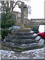
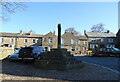
Anne T visited on 8th Aug 2019 - their rating: Cond: 3 Amb: 3 Access: 5 Askrigg Market Cross and Water Pump: It was dusk by the time we arrived back in Askrigg, and just as I started to take photographs, a large Tesco ‘click and collect’ van pulled up right next to the cross. Typical. With all the cars parked around what must have been the old village green, it wasn't a brilliant spot to linger.
")
This old market cross is recorded as Pastscape Monument No. 596113 and Historic England List ID 1131188, which simply say that the cross was picked up from the 1856 OS map.
Just across the road there is an old water pump, recorded as Historic England List ID 1301601, located at SD 94812 91033, but not mentioned in Pastscape.
Historic England cites a reference: "Hartley & Ingilby, "Yorkshire Village (1979)", page 148, which tells us: "In the autumn of 1830 the old cross was pulled down, and the following spring a new one, the present cross, was built by Leonard Heseltine, an Askrigg mason, who received about £21 2s 5d. Numerous persons were paid for taking away stones, 'raising the pillar' … in 1849 the same mason erected a substantial pump in a handsome stone case. Although later the pump was discarded for a time, it was replaced and still stands in the marketplace".
Whilst the shaft of this market cross is therefore 'modern', the steps upon which it sits appear much older. The entry in British Listed Buildings tells us: "(There is a) base of 6 octagonal steps. (The shaft) replaces an older cross, the market charter having been granted in 1587". So, presumably the steps date from the 16th century.
You may be viewing yesterday's version of this page. To see the most up to date information please register for a free account.
")
")
Do not use the above information on other web sites or publications without permission of the contributor.
Nearby Images from Geograph Britain and Ireland:
©2019(licence)
©2019(licence)
©2021(licence)
![SD9491 : Askrigg features [3] by Michael Dibb](https://s0.geograph.org.uk/geophotos/07/31/39/7313988_901a5d4f_120x120.jpg)
©2022(licence)
![SD9491 : Askrigg features [2] by Michael Dibb](https://s0.geograph.org.uk/geophotos/07/31/30/7313036_d42ebdc5_120x120.jpg)
©2022(licence)
The above images may not be of the site on this page, they are loaded from Geograph.
Please Submit an Image of this site or go out and take one for us!
Click here to see more info for this site
Nearby sites
Key: Red: member's photo, Blue: 3rd party photo, Yellow: other image, Green: no photo - please go there and take one, Grey: site destroyed
Download sites to:
KML (Google Earth)
GPX (GPS waypoints)
CSV (Garmin/Navman)
CSV (Excel)
To unlock full downloads you need to sign up as a Contributory Member. Otherwise downloads are limited to 50 sites.
Turn off the page maps and other distractions
Nearby sites listing. In the following links * = Image available
2.9km S 184° Addlebrough* Cairn (SD94598812)
3.1km S 188° Devil's Stone (Bainbridge) Natural Stone / Erratic / Other Natural Feature (SD94358799)
3.1km S 180° Addlebrough Cup-Marked Rock Rock Art (SD948879)
4.0km SSE 153° Dove Stones (Thornton Rust Moor) Rock Art (SD9663487493)
4.1km S 176° Stoney Raise* Cairn (SD95068691)
4.3km ESE 102° Carperby Stone Circle* Stone Circle (SD99009013)
5.1km SE 137° Castle Dykes* Henge (SD9823187289)
6.0km ESE 103° Carperby Cross* Ancient Cross (SE0063189729)
6.0km ESE 102° St Matthew's Well (Carperby)* Holy Well or Sacred Spring (SE0065689756)
7.3km NNW 329° Muker Stone Circle (SD911973)
9.7km ESE 121° Burton Moor* Ancient Village or Settlement (SE03118604)
10.2km NE 46° Maiden Castle (N Yorks)* Ancient Village or Settlement (SE02189808)
10.3km NE 47° Maiden Castle Barrow (Yorkshire North) Round Barrow(s) (SE02349814)
10.9km NE 53° Harkerside Moor circle* Stone Circle (SE035976)
11.9km SW 231° Mêni Mabbin Stone Row / Alignment (SD856835)
12.6km SSW 202° Yockenthwaite* Ring Cairn (SD8995779376)
13.0km WSW 241° Old Wife's Spring (Snaizeholme) Holy Well or Sacred Spring (SD834847)
14.4km E 96° Holy Trinity (Wensley)* Ancient Cross (SE09228954)
15.1km NE 51° Whitton Burn(Rock Art) Rock Art (NZ066005)
15.7km SSE 166° Little Hunters Sleets Cairn Cairn (SD98647576)
15.9km SSE 168° Tor Dike Ancient Village or Settlement (SD98137551)
15.9km NE 53° Forty Acres 03 (Stelling) Rock Art (NZ07580058)
16.6km N 3° Mudbeck Stone Circle (NY9562607618)
16.7km N 2° Mudbeck 2 (Arkengarthdale Moor) Rock Art (NY9527407728)
17.6km E 94° Fairy Well (Harmby)* Holy Well or Sacred Spring (SE12448969)
View more nearby sites and additional images


 We would like to know more about this location. Please feel free to add a brief description and any relevant information in your own language.
 Wir möchten mehr über diese Stätte erfahren. Bitte zögern Sie nicht, eine kurze Beschreibung und relevante Informationen in Deutsch hinzuzufügen.
 Nous aimerions en savoir encore un peu sur les lieux. S'il vous plaît n'hesitez pas à ajouter une courte description et tous les renseignements pertinents dans votre propre langue.
 Quisieramos informarnos un poco más de las lugares. No dude en añadir una breve descripción y otros datos relevantes en su propio idioma.