<< Our Photo Pages >> Ad Gefrin - Ancient Palace in England in Northumberland

Submitted by Andy B on Friday, 18 August 2006  Page Views: 21559

Multi-periodSite Name: Ad Gefrin Alternative Name: Yeavering
Country: England County: Northumberland Type: Ancient Palace
Nearest Town: Wooler  Nearest Village: Yeavering / Kirknewton
Map Ref: NT9270630484
Latitude: 55.567972N  Longitude: 2.11722W
Condition:
5Perfect
4Almost Perfect
3Reasonable but with some damage
2Ruined but still recognisable as an ancient site
1Pretty much destroyed, possibly visible as crop marks
0No data.
-1Completely destroyed
1 Ambience:
5Superb
4Good
3Ordinary
2Not Good
1Awful
0No data.
4 Access:
5Can be driven to, probably with disabled access
4Short walk on a footpath
3Requiring a bit more of a walk
2A long walk
1In the middle of nowhere, a nightmare to find
0No data.
5 Accuracy:
5co-ordinates taken by GPS or official recorded co-ordinates
4co-ordinates scaled from a detailed map
3co-ordinates scaled from a bad map
2co-ordinates of the nearest village
1co-ordinates of the nearest town
0no data
5

Internal Links:
External Links:

I have visited· I would like to visit

Anne T visited on 6th Aug 2017 - their rating: Cond: 1 Amb: 4 Access: 5 Ad Gefrin, Northumberland (near Yeavering): Trying to dry out from the walk to the Stob Stones, we decided to go back via Wooler and the A687 rather than back down the A68, passing Yeavering Bell on our way. Driving north, I was surprised to find we re-entered England from Scotland, back into Northumberland National Park. As we drove through Kirknewton, this ‘stone bus shelter’ and unusual gate posts caught my eye and we screeched to a halt. I was amazed that we’d never heard of this site at all, and I read the interpretation board, then walked into the field to look at the other board. In front of me there was nothing but tall, yellow grass, with a faint darker green line where a narrow track ran along the edge of the field. There was nothing on the interpretation board to tell us where about on the site we were. Seeing that the site spread across the road, I crossed and peered into the field. This, of course, now being England, I couldn’t just let myself into the field and wander around. There being an excellent 4G signal here, I pulled up the Gefrin website and was really surprised to find this site described as the most evocative archaeological sites in Northumberland and also one of the most remarkable archaeological discoveries of the 20th century. If I hadn’t been so wet and tired after a long day out, I’d have walked round the fields. As it was, we decided to return home, do some investigation and return to the site another day (adding to our ever growing list of ‘want to see’ sites).

morgainelefay visited - their rating: Cond: 1 Amb: 4 Access: 4

Gremlyn16 Gremlyn16 have visited here

Average ratings for this site from all visit loggers: Condition: 1 Ambience: 4 Access: 4.5
Ad Gefrin
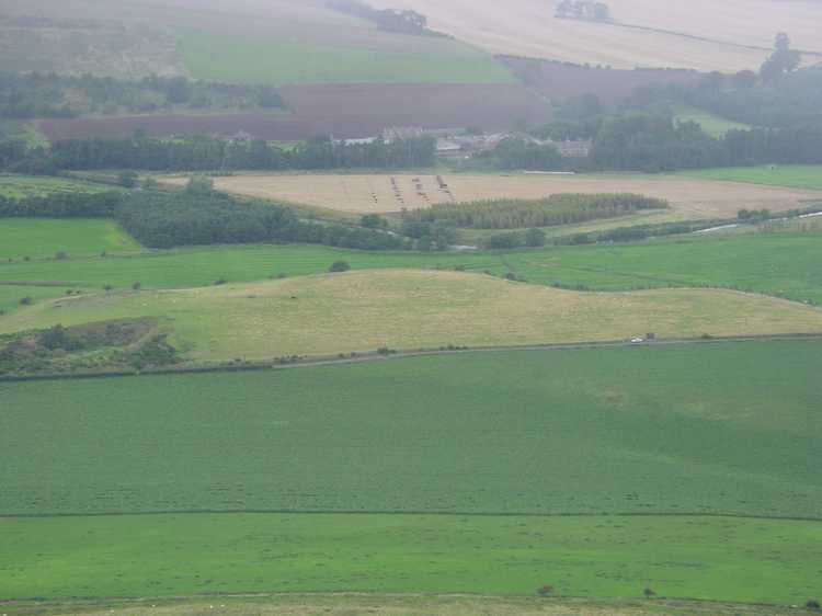
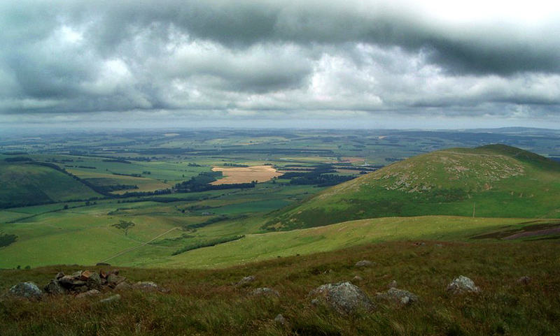
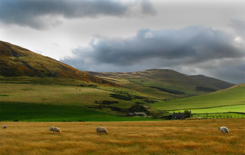
Ad Gefrin submitted by PaulH : Yeavering Bell hill fort View of Ad Gefrin at NT926305 At the foot of Yeavering Bell is the site of probably the most impaces dating from the seventh century. The palace, Ad Gefrin, (the place of the goats) was one of the homes of King Edwin of Northumbria, whose name was given to another town - 'Edwin's Burgh', now known as Edinburgh. It was at Ad Gefrin that St Paulinus baptised 3000 Nort... (Vote or comment on this photo)
Ancient Palace in Northumberland

Just over two miles north east of Hethpool, as the crow flies, in the township of Yeavering, lies the renowned site of Ad Gefrin, the Anglian palace complex. The site was the subject of excavation by Brian Hope-Taylor between 1952-1962

Whilst archaeologists still debate the results of Hope-Taylor’s excavations and the conclusions he drew from them, the basic outline seems clear. The complex was a major royal centre in the Anglian kingdom of Bernicia, and later Northumbria, with administrative and ceremonial functions, which involved the collection the renders provided by the surrounding peasant communities and redistributing them to key royal supporters and valued warriors. The complex contained a great defended or enclosed meeting place with adjacent halls and a timber-built ‘theatre’ or political arena.

More: Northumberland National Park and follow the links through to the external websites.

Note: New path and open access to Ad Gefrin, see comment
You may be viewing yesterday's version of this page. To see the most up to date information please register for a free account.
Ad Gefrin
Ad Gefrin submitted by Ethelwulf : A view of the hillfort on Yeavering Bell. The name of this hill means, "The hill of the wild goats" in old English. Taken from the higher summit of Eastor Tor, the hillfort can be seen below, on the far right, on the summit of Yeavering Bell. (4 comments - Vote or comment on this photo)

Ad Gefrin
Ad Gefrin submitted by Ethelwulf : Dark Age Buildings Gallery. This beautiful meadow in North-Northumberland, was the site of the Anglo-Saxon township, and wooden palace, of Gefrin (Celtic name) or yeavering (Anglo-Saxon mame) Where in 627, the missionary Paulinius converted Northumbrian Warrior King Edwin* and the Angles, from their Germanic Gods (Woden, Thunor, Freya) to Christianity. *King Edwin became 'Bretwalda' (Old English ... (8 comments - Vote or comment on this photo)

Ad Gefrin
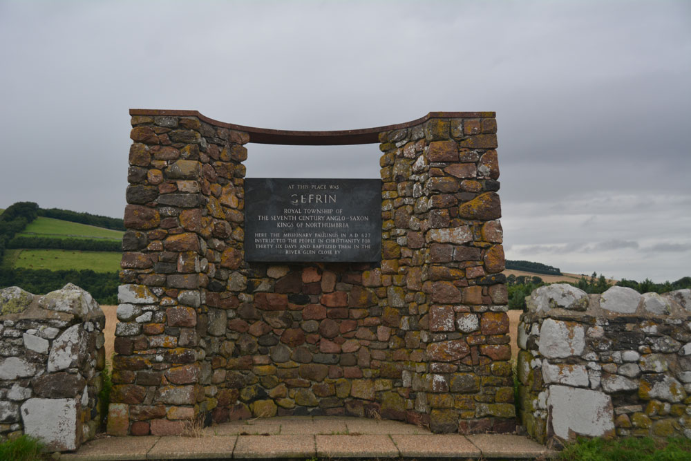
Ad Gefrin submitted by Anne T : Close up of the plaque which sums the historical significance of the site. I had absolutely no idea that this site was here, and want to know more - will be back to walk the fields in sunnier weather! (Vote or comment on this photo)

Ad Gefrin
Ad Gefrin submitted by Anne T : At first sight, I thought this was an unusual bus shelter, until I saw the plaque and we screeched to a halt to investigate further. (Vote or comment on this photo)

Ad Gefrin
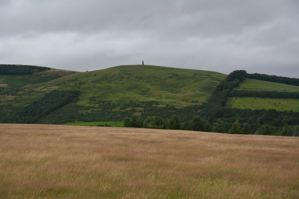
Ad Gefrin submitted by Anne T : Standing by the display board inside the field, looking north over the Glen valley. Don't have an OS map of this area, so am left wondering what the monument is on top of the hill in the distance (but will find out eventually!) (Vote or comment on this photo)

Ad Gefrin
Ad Gefrin submitted by Anne T : Standing just inside the field to the north of the B6351, looking at the back of the modern 'bus shelter/monument', looking west towards Kirknewton. No visible features from ground level in this field, but a splendid spot, with Yeavering Bell rising up behind me.

Do not use the above information on other web sites or publications without permission of the contributor.
Click here to see more info for this site

Nearby sites

Click here to view sites on an interactive OS map

Key: Red: member's photo, Blue: 3rd party photo, Yellow: other image, Green: no photo - please go there and take one, Grey: site destroyed

Download sites to:
KML (Google Earth)
GPX (GPS waypoints)
CSV (Garmin/Navman)
CSV (Excel)

To unlock full downloads you need to sign up as a Contributory Member. Otherwise downloads are limited to 50 sites.


Turn off the page maps and other distractions

Nearby sites listing. In the following links * = Image available
 153m ESE 110° Old Yeavering Henge* Henge (NT92853043)
 302m ESE 110° Battle Stone (Kirknewton)* Standing Stone (Menhir) (NT92993038)
 1.2km S 175° Yeavering Bell* Hillfort (NT92802931)
 1.3km WSW 238° St Gregory's Hill* Hillfort (NT9161329805)
 1.4km W 260° St. Gregory's The Great (Kirknewton)* Sculptured Stone (NT9134630251)
 1.9km SW 228° Torlee House, Kirknewton Rock Art (NT9127029190)
 1.9km SW 228° West Hill, Kirknewton* Rock Art (NT9125329199)
 2.0km SSE 162° Whitelaw (Kirknewton) Rock Art (NT9330028600)
 2.0km WSW 241° West Hill Camp* Hillfort (NT9096029518)
 2.3km NE 40° East Marleyknowe Henge Henge (NT94233226)
 2.4km NE 41° Milfield Cursus Cursus (NT943323)
 2.6km SE 125° Gleads Cleugh Hillfort (NT948290)
 2.6km ESE 122° White Law Hillfort (NT949291)
 2.8km NNE 27° Coupland Henge Henge (NT940330)
 3.1km ENE 65° Ewart Cursus Cursus (NT955318)
 3.2km E 86° West Akeld Steads Henge Henge (NT95883070)
 3.2km ENE 67° Ewart Park Henge Henge (NT95693172)
 3.4km NNE 22° Milfield Reconstructed Henge at Maelmin Heritage Centre* Henge (NT9400033631)
 3.5km SE 124° Harehope Hill* Hillfort (NT956285)
 3.6km SSW 194° Yeavering Bell Stone Circle Stone Circle (NT918270)
 3.7km NNE 22° Maelmin Anglo-Saxon Royal Settlement. Ancient Village or Settlement (NT941339)
 3.7km ENE 59° Thirlings Ancient Village or Settlement (NT959324)
 4.1km WSW 249° Hethpool 1 & 2 (Ewe Hill) Rock Art (NT8887028990)
 4.2km N 9° Milfield South Henge (NT934346)
 4.2km ESE 104° Bendor Stone* Standing Stone (Menhir) (NT9681929460)
View more nearby sites and additional images

<< The Creel Path

Boswarthen Cross >>

Please add your thoughts on this site

The Mind in the Cave

The Mind in the Cave

Sponsors

Auto-Translation (Google)

Translate from English into:

"Ad Gefrin" | Login/Create an Account | 12 News and Comments
  
Go back to top of page    Comments are owned by the poster. We aren't responsible for their content.
Re: Ad Gefrin by Gremlyn16 on Sunday, 24 October 2021
(User Info | Send a Message)
Visited today, loved the post with the goats head. Very relevant!
[ Reply to This ]

Re: Ad Gefrin by Anne T on Monday, 28 August 2017
(User Info | Send a Message)
For anyone who visits this site, you might be curious as to what the tall monument is on the hillside to the north, in the distance. Thanks to 'wooler.org.uk', they say that the monument is that of a Mr. Davidson, who was Chandler to Horatio Nelson. The Davidson family have a strange looking mausoleum at the church of St. Gregory the Great at Kirknewton, which is worth a visit if you like churches.
[ Reply to This ]

Re: Ad Gefrin by Anne T on Tuesday, 08 August 2017
(User Info | Send a Message)
The old link to NNNPA has changed, so I've updated this and added the official grid reference. Such an enigmatic and interesting site, and I'd no idea at all it even existed until we drove past it by chance.

A must to add to my 'wish list' to revisit, especially now I've got the information from the links on this Portal page. Thanks!
[ Reply to This ]

LiDAR of site of Ad Gefrin Anglo Saxon palace by Andy B on Friday, 12 May 2017
(User Info | Send a Message)

#LiDAR of site of Ad Gefrin (Yeavering) Anglo Saxon palace of the kings of Northumbria in 7th c AD - overlooked by Yeavering Bell hillfort pic.twitter.com/2fGju8hruA

— Mark Walters (@MarkWalters_) May 5, 2017


https://twitter.com/MarkWalters_/status/860644560254509058
[ Reply to This ]

Publications from the Gefrin Trust by Andy B on Friday, 12 May 2017
(User Info | Send a Message)
Occupation and Industrial Features in the Henge Monument at Yeavering

Brian Hope-Taylor’s Excavations on Yeavering Bell

Rediscovering the Landscape of the Northumbrian Kings

Yeavering: an Anglo-British Centre of Early Northumbria.

and more at
http://www.gefrintrust.org/publications.htm
[ Reply to This ]

Re: In the footsteps of ancient kings by Andy B on Monday, 28 September 2015
(User Info | Send a Message)
Prof. Howard M. R. Williams / Archaeodeath writes: Ad Gefrin/Yeavering is one of the most famous of archaeological sites from early medieval Britain. This is not simply because of the nature of the archaeology uncovered, but also the way it was explored and the interpretations made about it.

Excavations at this site directed by Brian Hope-Taylor revealed evidence for a multi-phased, short-lived royal Anglo-Saxon settlement that straddled the period of Christian conversion from the late sixth to late seventh centuries AD.

Yet Ad Gefrin‘s story is not static, it is ever-changing. The site remains a focus of intensive interest, debate and reinterpretation, and perhaps soon new field work.

From Hope-Taylor’s and subsequent excavations and survey, we understand Yeavering as a settlement or ‘township’ with evidence of careful planning and alignments around earlier prehistoric features, a sequence of monumental hall buildings and ancillary structures, evidence of metalworking, a possible pagan temple, a ‘theatre’ structure and the Great Enclosure used as either a fort and/or a corral. The site was a focus for burial and ritual activity: early burials focused on prehistoric monuments and later a wooden church because a focus of multiple phases of burial.

The way the site was dug was innovative. Chasing high-quality aerial photographs, the excavations were not keyhole, but opened up large areas to reveal and understand the complex sequence of timber buildings surviving only as post-holes and trench-slots. Artefact poor but feature-rich, this was challenging archaeology for the 1950s.

More at
https://howardwilliamsblog.wordpress.com/2014/06/16/ad-gefrin/
[ Reply to This ]

Guided tours of Gefrin, 7th & 8th Sept 2012 by Andy B on Monday, 03 September 2012
(User Info | Send a Message)
Tour the local site of the Anglo Saxon Royal Palace at Gefrin with Roger Miket, secretary of The Gefrin Trust.

Transport provided between Kirknewton and Gefrin.
How to get there:

From Wooler and the south

Head north on the A697 from Wooler, after about two miles take the left turn at Akeld (at the flag poles) onto the B6351 signposted Kirknewton & Kirk Yetholm. Kirknewton is just over two miles along this road.

From the north

On the A697 road approximately three miles south of Milfield turn right at Akeld (before the flag poles) onto the B6351 signposted Kirknewton & Kirk Yetholm. Kirknewton is just over two miles along this road.

Date: 7th Sep 2012 4:00pm, 8th Sep 2012 2:00pm
Location: Kirknewton Village Hall

http://www.northumberlandnationalpark.org.uk/visiting/whatson/eventhighlights/northumberland/guided-tour-of-gefrin2?SQ_CALENDAR_DATE=2012-09-07
[ Reply to This ]

Gefrin by Ethelwulf on Sunday, 20 August 2006
(User Info | Send a Message)
Click on the link below, to see the surrounding hills from the viewpoint of the Anglo-Saxon royal township

View from Gefrin
[ Reply to This ]

Re: In the footsteps of ancient kings by Ethelwulf on Sunday, 20 August 2006
(User Info | Send a Message)
I've recently (9 Aug 2006) submitted a Gefrin photo, showing the site and surrounding hills (Eastor and Westor Tor). and an informative link.


Did you know that Gefrin is a prime candidate for the epic Old English saga, "Beowulf"...I suspect that the flat top of Eastor Tor, could well have been the 7th century author's inspiration for "Grendel's lair"....
[ Reply to This ]

Yeavering Saxon Royal Palace by Andy B on Friday, 18 August 2006
(User Info | Send a Message)
Yeavering, in north Northumberland, is arguably one of the most important Anglo-Saxon sites in the country. Northumbria was one of four main Anglo-Saxon kingdoms during the 7th century, and Ad Gefrin (as Yeavering was known) is the best-known excavated example of a royal centre of the kings of Northumbria.

http://www.pastperfect.info/sites/yeavering/index.html
[ Reply to This ]

In the footsteps of ancient kings by Andy B on Friday, 18 August 2006
(User Info | Send a Message)
A new path and an area of permissive open access allowing people to follow in the footsteps of ancient Anglo Saxon kings has been opened up with the help of Defra.

Ad Gefrin, literally translated as "at the hill of the goats", which lies at the foot of Yeavering Bell in the Northumberland National Park, was the Royal Township of the 7th Century Anglo Saxon kings of Northumbria. It is probably one of the most important archaeological discoveries of the last century.

The eighth century monk Bede gave the township its only real historical reference in his Historia Ecclesiastica, identifying the locality and that it stood near the river Glen in what is now known as Glendale.

But in the 13 centuries that have passed, according to Bede, the palace was abandoned and with no visible evidence of its existence the actual location of the site was forgotten.

That was until 1949 when an aerial archaeological survey of the area found an impressive series of crop markings.

A detailed excavation was undertaken between 1953 and 1962. Led by Brian Hope-Taylor, it revealed a complex of great halls or palaces, some more than 80 feet in length, along with ancillary buildings such as weaving sheds and a very early Christian church.

A large timber amphitheatre for outdoor gatherings was also discovered.

Until recently, the significance of the site was marked by a roadside monument with a simple plaque.

But in April last year the land that included the northern half of the settlement and an adjacent redundant sand and gravel quarry was bought with a view to placing the management and eventual ownership of the site into the hands of a trust.

Management of the site now rests with The Gefrin Trust, a partnership between the local community, Northumberland County Council, Northumberland National Park Authority, English Heritage, Durham University and private specialist interests. The trust aims to ensure the site is saved from future deterioration, open up access for visitors and provide on-site information about its history.

Now, thanks to a new permissive access agreement drawn up through Defra's Countryside Stewardship Scheme, a new footpath, with specially-designed information panels, will allow visitors to explore the site and learn more about its rich history.

More: Northumberland Today
[ Reply to This ]

Your Name: Anonymous [ Register Now ]
Subject:


Add your comment or contribution to this page. Spam or offensive posts are deleted immediately, don't even bother

<<< What is five plus one as a number? (Please type the answer to this question in the little box on the left)
You can also embed videos and other things. For Youtube please copy and paste the 'embed code'.
For Google Street View please include Street View in the text.
Create a web link like this: <a href="https://www.megalithic.co.uk">This is a link</a>  

Allowed HTML is:
<p> <b> <i> <a> <img> <em> <br> <strong> <blockquote> <tt> <li> <ol> <ul> <object> <param> <embed> <iframe>

We would like to know more about this location. Please feel free to add a brief description and any relevant information in your own language.
Wir möchten mehr über diese Stätte erfahren. Bitte zögern Sie nicht, eine kurze Beschreibung und relevante Informationen in Deutsch hinzuzufügen.
Nous aimerions en savoir encore un peu sur les lieux. S'il vous plaît n'hesitez pas à ajouter une courte description et tous les renseignements pertinents dans votre propre langue.
Quisieramos informarnos un poco más de las lugares. No dude en añadir una breve descripción y otros datos relevantes en su propio idioma.