<< Text Pages >> Battlesbury Bowl Barrow 1 - Round Barrow(s) in England in Wiltshire
Submitted by coldrum on Monday, 10 August 2009 Page Views: 4056
Neolithic and Bronze AgeSite Name: Battlesbury Bowl Barrow 1Country: England County: Wiltshire Type: Round Barrow(s)
Map Ref: ST89804545
Latitude: 51.208164N Longitude: 2.147394W
Condition:
| 5 | Perfect |
| 4 | Almost Perfect |
| 3 | Reasonable but with some damage |
| 2 | Ruined but still recognisable as an ancient site |
| 1 | Pretty much destroyed, possibly visible as crop marks |
| 0 | No data. |
| -1 | Completely destroyed |
| 5 | Superb |
| 4 | Good |
| 3 | Ordinary |
| 2 | Not Good |
| 1 | Awful |
| 0 | No data. |
| 5 | Can be driven to, probably with disabled access |
| 4 | Short walk on a footpath |
| 3 | Requiring a bit more of a walk |
| 2 | A long walk |
| 1 | In the middle of nowhere, a nightmare to find |
| 0 | No data. |
| 5 | co-ordinates taken by GPS or official recorded co-ordinates |
| 4 | co-ordinates scaled from a detailed map |
| 3 | co-ordinates scaled from a bad map |
| 2 | co-ordinates of the nearest village |
| 1 | co-ordinates of the nearest town |
| 0 | no data |
Be the first person to rate this site - see the 'Contribute!' box in the right hand menu.
Internal Links:
External Links:
Round Barrow(s) in Wiltshire
Originally sited on the false crest of Battlesbury Hill, now set behind the hillfort rampart. Measuring 20m across and 3m high.
https://www.pastscape.org.uk/hob.aspx?hob_id=889228
You may be viewing yesterday's version of this page. To see the most up to date information please register for a free account.
Do not use the above information on other web sites or publications without permission of the contributor.
Nearby Images from Geograph Britain and Ireland:
©2006(licence)
©2006(licence)
©2021(licence)
©2010(licence)
©2021(licence)
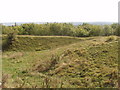
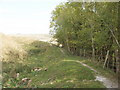
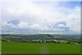
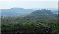
The above images may not be of the site on this page, they are loaded from Geograph.
Please Submit an Image of this site or go out and take one for us!
Click here to see more info for this site
Nearby sites
Key: Red: member's photo, Blue: 3rd party photo, Yellow: other image, Green: no photo - please go there and take one, Grey: site destroyed
Download sites to:
KML (Google Earth)
GPX (GPS waypoints)
CSV (Garmin/Navman)
CSV (Excel)
To unlock full downloads you need to sign up as a Contributory Member. Otherwise downloads are limited to 50 sites.
Turn off the page maps and other distractions
Nearby sites listing. In the following links * = Image available
32m WSW 251° Battlesbury Bowl barrow 2 Round Barrow(s) (ST89774544)
50m S 179° Battlesbury hillfort Barrows Round Barrow(s) (ST898454)
50m S 179° Battlesbury bowl barrow 3 Round Barrow(s) (ST898454)
150m N 360° Battlesbury Camp* Hillfort (ST898456)
974m S 183° King Barrow (Warminster) Long Barrow (ST8975044477)
1.1km ESE 119° Middle Hill* Round Barrow(s) (ST908449)
1.5km SSW 200° Boreham Mill Barrows Round Barrow(s) (ST89274400)
1.7km N 349° Mancombe Down Enclosure Ancient Village or Settlement (ST89494710)
1.8km NNE 14° Warminster Long Barrow Long Barrow (ST90244717)
1.8km SE 134° Scratchbury Camp* Hillfort (ST911442)
1.8km W 274° Cop Heap Round Barrow(s) (ST87984558)
2.0km NNE 17° Oxendean Down barrow Round Barrow(s) (ST904474)
2.1km NNE 16° Oxendean Down Barrow Round Barrow(s) (ST90404746)
2.1km NNE 16° Warminster Bowl Barrow Round Barrow(s) (ST90384747)
2.1km ENE 76° Norton Bavant 14 Long Barrow (ST91854596)
2.4km WNW 296° Warminster Round Barrow(s) (ST87674647)
2.5km WNW 288° Arn Hill Barrow Round Barrow(s) (ST87444623)
2.5km NNE 12° Oxendean Bottom Barrow Round Barrow(s) (ST90314788)
2.5km WNW 287° Arn Hill barrow Round Barrow(s) (ST874462)
2.8km WNW 303° Colloway Clump Barrow Round Barrow(s) (ST87464695)
2.8km E 80° Norton Bavant 13 Long Barrow (ST92594595)
2.9km NW 304° Arn Hill Long Barrow Long Barrow (ST874471)
2.9km ESE 117° West Hill long barrow Long Barrow (ST924441)
3.0km N 9° Warminster Down Tumulus Round Barrow(s) (ST90294841)
3.5km N 10° Bratton Round Barrow(s) (ST90434892)
View more nearby sites and additional images


 We would like to know more about this location. Please feel free to add a brief description and any relevant information in your own language.
 Wir möchten mehr über diese Stätte erfahren. Bitte zögern Sie nicht, eine kurze Beschreibung und relevante Informationen in Deutsch hinzuzufügen.
 Nous aimerions en savoir encore un peu sur les lieux. S'il vous plaît n'hesitez pas à ajouter une courte description et tous les renseignements pertinents dans votre propre langue.
 Quisieramos informarnos un poco más de las lugares. No dude en añadir una breve descripción y otros datos relevantes en su propio idioma.