<< Our Photo Pages >> Tommy Stout's Well (Thornley Gate) - Holy Well or Sacred Spring in England in Northumberland
Submitted by Anne T on Tuesday, 01 January 2019 Page Views: 1298
Springs and Holy WellsSite Name: Tommy Stout's Well (Thornley Gate)Country: England
NOTE: This site is 1.0 km away from the location you searched for.
County: Northumberland Type: Holy Well or Sacred Spring
Nearest Town: Allenbanks Nearest Village: Catton / Thornley Gate
Map Ref: NY83065661
Latitude: 54.903920N Longitude: 2.265708W
Condition:
| 5 | Perfect |
| 4 | Almost Perfect |
| 3 | Reasonable but with some damage |
| 2 | Ruined but still recognisable as an ancient site |
| 1 | Pretty much destroyed, possibly visible as crop marks |
| 0 | No data. |
| -1 | Completely destroyed |
| 5 | Superb |
| 4 | Good |
| 3 | Ordinary |
| 2 | Not Good |
| 1 | Awful |
| 0 | No data. |
| 5 | Can be driven to, probably with disabled access |
| 4 | Short walk on a footpath |
| 3 | Requiring a bit more of a walk |
| 2 | A long walk |
| 1 | In the middle of nowhere, a nightmare to find |
| 0 | No data. |
| 5 | co-ordinates taken by GPS or official recorded co-ordinates |
| 4 | co-ordinates scaled from a detailed map |
| 3 | co-ordinates scaled from a bad map |
| 2 | co-ordinates of the nearest village |
| 1 | co-ordinates of the nearest town |
| 0 | no data |
Be the first person to rate this site - see the 'Contribute!' box in the right hand menu.
Internal Links:
External Links:
I have visited· I would like to visit
Anne T visited on 1st Jan 2019 - their rating: Cond: 3 Amb: 4 Access: 4 Tommy Stout's Well, Thornley Gate: Another site ticked off the list of Isaac’sTea Trail. This is obviously a popular spot for walkers, as there are paths both sides of the river, and we passed a number of dog walkers. The small layby on the south side of the river was full (2 cars), so we parked on the grass verge by the entrance to the Allen Smelt Mill.
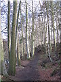
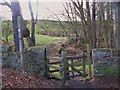
The well is through the kissing gate on the opposite side of the road from the smelt mill gate, with the well some 15m further on, to your left hand side.
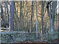
Water appears out of the hillside below a small protruding dressed stone, largely hidden by moss and lichen. There is a fair flow of clear water which comes out; I did taste it, but there was nothing really to taste. Above the simple, dressed stone well head with drain there is a marshy area in the field above, from which the source of the water appears to come. Between the well and the kissing gate, on the other side of the fence, is a stunning little stream with a mini waterfall, which is a different water course to that of the well.
Also being interested in some industrial archaeology, we spent some time wandering around the fascinating remains of the smelting works opposite. There is still quite a lot left, and it is left accessible for visitors. Some of the underground flues are currently being excavated.
 (PID:190637)")
Marked on the OS map, this well can be found just west of the B6295 and south west of the River East Allen, opposite the site of the Allen Smelt Mill (now partly renovated as a small business park).
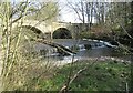
To find this well, from the southern end of Catton, the roads diverge with the B6303 heading south east towards Allendale Town and the B6295 heading south towards Thornley Gate. Take the B6295 and continue along the road until you cross the bridge over the River East Allen. The well is immediately at the south western end of the bridge, where a small layby allows parking for two cars. A small kissing gate gives access to a path at the southern side of the river. The well is approx. 15-20m west of the gate.
The well is part of a small dressed stone wall to the left of the path. At the time of our visit, a steady stream of clear water issued from underneath a small dressed stone which protruded from the wall, draining into a very small basin and modern drain. The "Isaac's Tea Trail" booklet tells us the well was probably named after a manager of the smelt mill, but the site of the well looks far older. Above the well is a hill with a marshy area above. It looks as if water collects into this marshy area, then is piped out into the well basin below.
I am currently trying to find out more information from the Newcastle Antiquarian's records to confirm this as a holy well. For slightly more information see Pastscape Monument No. 958098.
You may be viewing yesterday's version of this page. To see the most up to date information please register for a free account.
 (PID:190639)")
 (PID:190638)")
Do not use the above information on other web sites or publications without permission of the contributor.
Nearby Images from Geograph Britain and Ireland:
©2008(licence)
©2008(licence)
©2008(licence)
©2008(licence)
©2023(licence)
The above images may not be of the site on this page, they are loaded from Geograph.
Please Submit an Image of this site or go out and take one for us!
Click here to see more info for this site
Nearby sites
Key: Red: member's photo, Blue: 3rd party photo, Yellow: other image, Green: no photo - please go there and take one, Grey: site destroyed
Download sites to:
KML (Google Earth)
GPX (GPS waypoints)
CSV (Garmin/Navman)
CSV (Excel)
To unlock full downloads you need to sign up as a Contributory Member. Otherwise downloads are limited to 50 sites.
Turn off the page maps and other distractions
Nearby sites listing. In the following links * = Image available
3.3km NW 321° High Shaw Farm (Staward) Rock Art (NY8098959165)
3.4km NE 50° Bulman's Rigg (Allendale) Rock Art (NY8569958770)
4.5km ENE 60° Stobs Cross (Tynedale) Rock Art (NY8697458832)
4.9km E 93° Crawberry Hill* Stone Circle (NY880563)
5.1km E 98° Burntridge Moor Rock Art (NY8811155864)
6.9km ENE 62° Jingling Gate* Ancient Village or Settlement (NY89145984)
7.0km NW 309° East Steel Farm* Modern Stone Circle etc (NY776610)
7.2km NE 44° The Hanging Stone (Haydon)* Standing Stone (Menhir) (NY8810161779)
7.7km SSW 207° Limestone Brae (West Allen)* Ancient Cross (NY79534973)
7.9km SW 225° Park House (West Allen)* Marker Stone (NY7749151027)
8.1km NNW 336° Allen Banks Rock Art (NY7980064010)
8.4km NNW 330° St Cuthbert's Church, Beltingham* Early Christian Sculptured Stone (NY789639)
9.0km N 355° Tony's Patch 1* Rock Art (NY8228165572)
9.8km N 359° Joicey Shaft Cairn* Round Barrow(s) (NY8286966437)
9.9km N 359° Joicey Shaft b* Rock Art (NY8287266469)
9.9km N 359° Joicey Shaft a* Rock Art (NY8291066485)
11.0km WSW 249° Wolf Hills Spearhead Find Site Ancient Mine, Quarry or other Industry (NY728527)
11.1km NNW 332° Long Stone (Barcombe Hill)* Ancient Cross (NY77896646)
11.3km NNW 335° Barcombe Hill Settlement* Ancient Village or Settlement (NY78306682)
11.4km NNW 328° Vindolanda Roman Fort* Stone Fort or Dun (NY7705266352)
12.1km NNW 342° Housesteads Mound* Misc. Earthwork (NY79386815)
12.2km NW 322° Smith's Shield Milestone* Marker Stone (NY7561766242)
12.3km NNW 342° Housesteads Tumulus* Artificial Mound (NY7938268330)
12.6km N 358° West Howden Hill* Ancient Village or Settlement (NY82666925)
12.7km NE 53° Seal Well (Hexham)* Holy Well or Sacred Spring (NY93246421)
View more nearby sites and additional images


 We would like to know more about this location. Please feel free to add a brief description and any relevant information in your own language.
 Wir möchten mehr über diese Stätte erfahren. Bitte zögern Sie nicht, eine kurze Beschreibung und relevante Informationen in Deutsch hinzuzufügen.
 Nous aimerions en savoir encore un peu sur les lieux. S'il vous plaît n'hesitez pas à ajouter une courte description et tous les renseignements pertinents dans votre propre langue.
 Quisieramos informarnos un poco más de las lugares. No dude en añadir una breve descripción y otros datos relevantes en su propio idioma.