<< Image Pages >> Hownam Law Hillfort - Hillfort in Scotland in Scottish Borders
Submitted by durhamnature on Thursday, 20 September 2012 Page Views: 5274
Iron Age and Later PrehistorySite Name: Hownam Law Hillfort Alternative Name: Hounam Law, Hounam HillCountry: Scotland County: Scottish Borders Type: Hillfort
Map Ref: NT7964022000
Latitude: 55.491367N Longitude: 2.323778W
Condition:
| 5 | Perfect |
| 4 | Almost Perfect |
| 3 | Reasonable but with some damage |
| 2 | Ruined but still recognisable as an ancient site |
| 1 | Pretty much destroyed, possibly visible as crop marks |
| 0 | No data. |
| -1 | Completely destroyed |
| 5 | Superb |
| 4 | Good |
| 3 | Ordinary |
| 2 | Not Good |
| 1 | Awful |
| 0 | No data. |
| 5 | Can be driven to, probably with disabled access |
| 4 | Short walk on a footpath |
| 3 | Requiring a bit more of a walk |
| 2 | A long walk |
| 1 | In the middle of nowhere, a nightmare to find |
| 0 | No data. |
| 5 | co-ordinates taken by GPS or official recorded co-ordinates |
| 4 | co-ordinates scaled from a detailed map |
| 3 | co-ordinates scaled from a bad map |
| 2 | co-ordinates of the nearest village |
| 1 | co-ordinates of the nearest town |
| 0 | no data |
Internal Links:
External Links:
")
Canmore site 58271
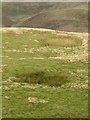
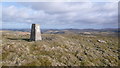
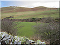
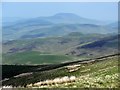
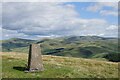
Hillfort between the Kale Water and the Bowmont Water, on the edge of the Cheviot Hills.
There is a very thorough description in Canmore.
You may be viewing yesterday's version of this page. To see the most up to date information please register for a free account.
Do not use the above information on other web sites or publications without permission of the contributor.
Nearby Images from Geograph Britain and Ireland:
©2011(licence)
©2008(licence)
©2018(licence)
©2013(licence)
©2023(licence)
The above images may not be of the site on this page, they are loaded from Geograph.
Please Submit an Image of this site or go out and take one for us!
Click here to see more info for this site
Nearby sites
Key: Red: member's photo, Blue: 3rd party photo, Yellow: other image, Green: no photo - please go there and take one, Grey: site destroyed
Download sites to:
KML (Google Earth)
GPX (GPS waypoints)
CSV (Garmin/Navman)
CSV (Excel)
To unlock full downloads you need to sign up as a Contributory Member. Otherwise downloads are limited to 50 sites.
Turn off the page maps and other distractions
Nearby sites listing. In the following links * = Image available
2.7km SSW 193° Hownam Rings Hill Fort* Hillfort (NT79041939)
2.8km S 191° The Shearers* Stone Row / Alignment (NT79101925)
3.2km SSW 196° Horseshoe Wood (Hownam)* Standing Stone (Menhir) (NT78741890)
3.3km SSW 200° Horseshoe Wood Settlement* Ancient Village or Settlement (NT78511891)
4.2km SE 131° Calroust Hillfort* Hillfort (NT828192)
5.2km SSW 199° Little Heuch Law Cairn* Cairn (NT77921705)
5.5km SSW 199° Dodlaw Burn* Standing Stone (Menhir) (NT77791681)
5.5km ESE 107° Fasset Hill (Sourhope)* Ancient Village or Settlement (NT8492520359)
5.5km ESE 113° Sourhope Hillfort* Hillfort (NT8475219825)
5.7km SSW 197° Dodlaw Cairn Round Cairn (NT77991655)
6.1km SSW 208° Chatto Craig* Hillfort (NT76701662)
6.7km SW 220° Five Stanes A* Stone Circle (NT75261686)
6.8km ESE 113° Bonnielaws Hillfort* Hillfort (NT8589319312)
7.1km SSW 212° Dere Street stone* Standing Stone (Menhir) (NT75801604)
7.1km NE 42° Sheilknowe Burn Enclosure* Ancient Village or Settlement (NT84462728)
7.2km NE 43° Shielknowe Burn Scooped Settlement* Ancient Village or Settlement (NT8457727300)
7.4km SW 217° Trestle Cairn* Stone Circle (NT75181612)
7.4km NE 47° Stob Rig (Yetholm)* Misc. Earthwork (NT85092704)
7.5km NE 47° Stob Stones* Standing Stones (NT85142710)
7.5km NE 41° Green Humbleton Hillfort* Hillfort (NT846277)
7.6km NNW 342° Frogden Stone Circle (NT77372922)
7.6km SW 217° Five Stanes B Stone Circle (NT7516)
7.6km NE 42° Kirk Yetholm* Ancient Village or Settlement (NT848276)
7.6km NE 43° Green Humbleton Settlement* Ancient Village or Settlement (NT84832758)
7.7km SE 130° Stoney Knowe Hillfort* Hillfort (NT855170)
View more nearby sites and additional images


 We would like to know more about this location. Please feel free to add a brief description and any relevant information in your own language.
 Wir möchten mehr über diese Stätte erfahren. Bitte zögern Sie nicht, eine kurze Beschreibung und relevante Informationen in Deutsch hinzuzufügen.
 Nous aimerions en savoir encore un peu sur les lieux. S'il vous plaît n'hesitez pas à ajouter une courte description et tous les renseignements pertinents dans votre propre langue.
 Quisieramos informarnos un poco más de las lugares. No dude en añadir una breve descripción y otros datos relevantes en su propio idioma.