


<< Our Photo Pages >> Philpin Sleights - Rock Outcrop in England in Yorkshire (North)
Submitted by DavidShepherd on Thursday, 10 May 2018 Page Views: 1867
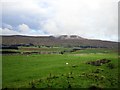
Natural PlacesSite Name: Philpin SleightsCountry: England
NOTE: This site is 0.4 km away from the location you searched for.
County: Yorkshire (North) Type: Rock Outcrop
Nearest Town: Kirby Lonsdale / Hawes Nearest Village: Weathercote
Map Ref: SD7486677760
Latitude: 54.194978N Longitude: 2.386725W
Condition:
| 5 | Perfect |
| 4 | Almost Perfect |
| 3 | Reasonable but with some damage |
| 2 | Ruined but still recognisable as an ancient site |
| 1 | Pretty much destroyed, possibly visible as crop marks |
| 0 | No data. |
| -1 | Completely destroyed |
| 5 | Superb |
| 4 | Good |
| 3 | Ordinary |
| 2 | Not Good |
| 1 | Awful |
| 0 | No data. |
| 5 | Can be driven to, probably with disabled access |
| 4 | Short walk on a footpath |
| 3 | Requiring a bit more of a walk |
| 2 | A long walk |
| 1 | In the middle of nowhere, a nightmare to find |
| 0 | No data. |
| 5 | co-ordinates taken by GPS or official recorded co-ordinates |
| 4 | co-ordinates scaled from a detailed map |
| 3 | co-ordinates scaled from a bad map |
| 2 | co-ordinates of the nearest village |
| 1 | co-ordinates of the nearest town |
| 0 | no data |
Be the first person to rate this site - see the 'Contribute!' box in the right hand menu.
Internal Links:
External Links:
")
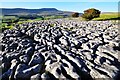
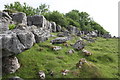
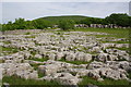
The term propped stone refers to large boulders that have been elevated, with one or small smaller rocks placed underneath. They may appear to be natural features - glacial erratics, outcomes of landslip, and so in - but in places where there is no natural process that can account for the feature.
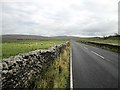
This propped stone is located in the Yorkshire Dales, north east of Weathercote and Chapel-le-Dale, south of the B6255 (Low Sleights Road). Raised almost in situ, there is a gap in the limestone pavement 4m from this feature, with the slab matching this space. The top stone/slab is Great Scar Limestone, 45cms thick, 125cms wide and 150cms long. The single prop is a portion of fretted limestone similar to the raised slab and the pavement underneath. The prop has two points of contact with the slab, which is angled at around 15° with a direction of 285°. [Whilst the top stone is likely to have come from the adjacent space in the limestone pavement, it might be considered to be associated with nearby pavement quarrying.]
Thanks to David Shepherd for the information and grid reference. See Shepherd D. 2013. Propped stones: the modification of natural features and construction of place. Time and Mind. Vol 6 Issue 3 November 2013. pp 263-86. Bloomsbury.
Page by Anne Tate
You may be viewing yesterday's version of this page. To see the most up to date information please register for a free account.
Do not use the above information on other web sites or publications without permission of the contributor.
Nearby Images from Geograph Britain and Ireland:
©2009(licence)
©2016(licence)
©2016(licence)
©2011(licence)
©2011(licence)
The above images may not be of the site on this page, they are loaded from Geograph.
Please Submit an Image of this site or go out and take one for us!
Click here to see more info for this site
Nearby sites
Key: Red: member's photo, Blue: 3rd party photo, Yellow: other image, Green: no photo - please go there and take one, Grey: site destroyed
Download sites to:
KML (Google Earth)
GPX (GPS waypoints)
CSV (Garmin/Navman)
CSV (Excel)
To unlock full downloads you need to sign up as a Contributory Member. Otherwise downloads are limited to 50 sites.
Turn off the page maps and other distractions
Nearby sites listing. In the following links * = Image available
472m SSW 207° Keld Bank Settlement* Ancient Village or Settlement (SD74657734)
518m SSW 192° Keld Bank (Ingleborough)* Rock Art (SD7475977253)
962m ENE 74° Sleights Pasture Propped Stone* Rock Outcrop (SD7579578018)
1.0km NE 53° Sleights Pasture Round Barrow* Round Cairn (SD75677836)
1.8km NE 48° Batty Wife Hole Ring Cairn (SD76227895)
3.3km SSW 191° Ingleborough Camp* Hillfort (SD7419374511)
4.1km WNW 283° Apron Full of Stones* Ring Cairn (SD709787)
4.6km WNW 285° Yordas cave* Cave or Rock Shelter (SD704790)
4.7km SE 130° Skirtful of Stones (Ingleborough) Cairn (SD785747)
4.8km WSW 243° Twisleton Scar* Rock Outcrop (SD70597563)
5.1km SW 218° White Scars Cairn (SD717738)
6.1km SSE 164° Dudderhouse Hill* Burial Chamber or Dolmen (SD76547190)
6.7km S 175° Ingleborough Cave* Natural Stone / Erratic / Other Natural Feature (SD7542071093)
7.9km SSE 167° Norber Erratics Natural Stone / Erratic / Other Natural Feature (SD76597003)
10.0km W 264° Leck Hall* Ancient Village or Settlement (SD64927677)
10.4km WNW 285° Brownthwaite Pike Round Cairn* Round Cairn (SD6477280479)
11.0km NE 51° Old Wife's Spring (Snaizeholme) Holy Well or Sacred Spring (SD834847)
11.1km W 281° Casterton* Stone Circle (SD63937999)
11.2km SSE 160° Feizor (Lawkland) Standing Stone (Menhir) (SD78586718)
11.4km SSE 154° Feizor Thwaite (Lawkland)* Ring Cairn (SD79796747)
11.6km SSE 153° Feizor Celtic Wall* Misc. Earthwork (SD8008067386)
11.6km ESE 112° Giant's Graves (Halton Gill) Cairn (SD8564873346)
12.1km ENE 61° Mêni Mabbin Stone Row / Alignment (SD856835)
12.4km SSE 152° Feizor Thwaite Propped Stone* Rock Outcrop (SD8057466703)
12.6km SSE 153° Sheep Scar Circle (Giggleswick) Ring Cairn (SD8051366473)
View more nearby sites and additional images


 We would like to know more about this location. Please feel free to add a brief description and any relevant information in your own language.
 Wir möchten mehr über diese Stätte erfahren. Bitte zögern Sie nicht, eine kurze Beschreibung und relevante Informationen in Deutsch hinzuzufügen.
 Nous aimerions en savoir encore un peu sur les lieux. S'il vous plaît n'hesitez pas à ajouter une courte description et tous les renseignements pertinents dans votre propre langue.
 Quisieramos informarnos un poco más de las lugares. No dude en añadir una breve descripción y otros datos relevantes en su propio idioma.