<< Our Photo Pages >> Cold Ashton Round Barrows - Round Barrow(s) in England in Gloucestershire
Submitted by 4clydesdale7 on Saturday, 08 September 2012 Page Views: 4912
Neolithic and Bronze AgeSite Name: Cold Ashton Round Barrows Alternative Name: Cold Ashton 1 and 2Country: England County: Gloucestershire Type: Round Barrow(s)
Nearest Town: Bath Nearest Village: Cold Ashton
Map Ref: ST73257045
Latitude: 51.432414N Longitude: 2.386186W
Condition:
| 5 | Perfect |
| 4 | Almost Perfect |
| 3 | Reasonable but with some damage |
| 2 | Ruined but still recognisable as an ancient site |
| 1 | Pretty much destroyed, possibly visible as crop marks |
| 0 | No data. |
| -1 | Completely destroyed |
| 5 | Superb |
| 4 | Good |
| 3 | Ordinary |
| 2 | Not Good |
| 1 | Awful |
| 0 | No data. |
| 5 | Can be driven to, probably with disabled access |
| 4 | Short walk on a footpath |
| 3 | Requiring a bit more of a walk |
| 2 | A long walk |
| 1 | In the middle of nowhere, a nightmare to find |
| 0 | No data. |
| 5 | co-ordinates taken by GPS or official recorded co-ordinates |
| 4 | co-ordinates scaled from a detailed map |
| 3 | co-ordinates scaled from a bad map |
| 2 | co-ordinates of the nearest village |
| 1 | co-ordinates of the nearest town |
| 0 | no data |
Be the first person to rate this site - see the 'Contribute!' box in the right hand menu.
Internal Links:
External Links:
I have visited· I would like to visit
4clydesdale7 visited on 6th Sep 2012 - their rating: Cond: 3 Amb: 4 Access: 3 Bit of a 'claggy' walk east along the Cotswold Way from the Civil War Battlefield just north of Lansdown but when you get there it is so peaceful - some lovely views
")
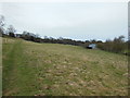
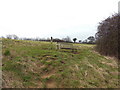
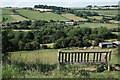
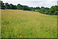
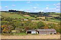
They lie just north of the Cotswold Way below and to the east of the site of a great battle in fought on 5th July 1643 at Lansdown near Bath Racecourse during the English Civil War - on walking along the road between Lansdown and Wick the battlefield is just to the east of the road and is marked out with orange metal flags - about 1km further east along the Cotswold Way the pair of barrows are tucked away in the SE corner of a small field above Goudie's Farm - and they are in a splendidly peaceful setting.
The Easterly Barrow is topped by a stunted tree with limited foliage and is slightly taller (1.7m) than the Westerly Barrow (approx 1m) - they were excavated in 1909 when a substantial number of flints and cores were unearthed - not surprising when you are near Toghill.
Mentioned in the Transactions of Bristol and Gloucestershire Archaeological Society 1960 Vol 79 part 1 page 109 and on the pastscape website South Gloucestershire: Cold Ashton: 204969; a very enjoyable walk with some gorgeous views.
You may be viewing yesterday's version of this page. To see the most up to date information please register for a free account.
")
")
")
Do not use the above information on other web sites or publications without permission of the contributor.
Nearby Images from Geograph Britain and Ireland:
©2013(licence)
©2013(licence)
©2017(licence)
©2016(licence)
©2023(licence)
The above images may not be of the site on this page, they are loaded from Geograph.
Please Submit an Image of this site or go out and take one for us!
Click here to see more info for this site
Nearby sites
Key: Red: member's photo, Blue: 3rd party photo, Yellow: other image, Green: no photo - please go there and take one, Grey: site destroyed
Download sites to:
KML (Google Earth)
GPX (GPS waypoints)
CSV (Garmin/Navman)
CSV (Excel)
To unlock full downloads you need to sign up as a Contributory Member. Otherwise downloads are limited to 50 sites.
Turn off the page maps and other distractions
Nearby sites listing. In the following links * = Image available
1.6km NW 309° Freezing Hill Camp* Misc. Earthwork (ST72007148)
2.1km N 354° Labourer's Stone* Marker Stone (ST73057251)
2.4km SW 229° Lansdown Camp* Misc. Earthwork (ST71446892)
2.4km SSW 195° St Alphages Well* Holy Well or Sacred Spring (ST72606815)
2.6km SW 234° Lansdown Tumuli* Barrow Cemetery (ST7114968962)
2.8km SW 236° North Stoke Promontory Fort* Promontory Fort / Cliff Castle (ST70886888)
3.0km WNW 298° Wick Burial Chamber (Gloucestershire)* Burial Chamber or Dolmen (ST70587188)
3.5km SSE 154° St Mary's Well (Charlcombe)* Holy Well or Sacred Spring (ST748673)
4.4km SE 124° Solsbury Hill* Hillfort (ST76876797)
5.0km W 261° Bitton Camp* Misc. Earthwork (ST68276968)
5.2km NNW 328° Abson Church* Sculptured Stone (ST70557485)
5.3km SSE 148° Kensington Meadows Holed Megalith Holed Stone
5.5km W 259° Bitton Round Barrow* Round Barrow(s) (ST67806945)
5.7km SSE 162° Bath Postal Museum* Museum (ST7504564998)
6.0km SSE 162° Sacred Spring, Bath* Holy Well or Sacred Spring (ST7505364726)
6.3km N 7° Dyrham Camp* Hillfort (ST741767)
6.4km E 94° Three Shires Stones* Modern Stone Circle etc (ST7961070021)
6.4km NW 314° St Anne’s well (Siston)* Holy Well or Sacred Spring (ST68697494)
6.5km SSE 149° Bathampton Round Barrow 2* Round Barrow(s) (ST76616489)
6.6km SE 143° Bathampton* Standing Stones (ST772652)
6.8km NNE 17° Dyrham and Hinton* Chambered Tomb (ST75307689)
6.9km SE 142° Bathampton Camp* Hillfort (ST77456502)
7.3km NW 319° Shortwood Hill barrow* Round Barrow(s) (ST68457600)
7.4km NNE 29° West Littleton Down* Round Barrow(s) (ST769769)
8.4km NW 315° Shortwood Circle* Modern Stone Circle etc (ST67277642)
View more nearby sites and additional images


 We would like to know more about this location. Please feel free to add a brief description and any relevant information in your own language.
 Wir möchten mehr über diese Stätte erfahren. Bitte zögern Sie nicht, eine kurze Beschreibung und relevante Informationen in Deutsch hinzuzufügen.
 Nous aimerions en savoir encore un peu sur les lieux. S'il vous plaît n'hesitez pas à ajouter une courte description et tous les renseignements pertinents dans votre propre langue.
 Quisieramos informarnos un poco más de las lugares. No dude en añadir una breve descripción y otros datos relevantes en su propio idioma.