<< Our Photo Pages >> Apron Full of Stones - Ring Cairn in England in Yorkshire (North)
Submitted by Andy B on Monday, 23 August 2010 Page Views: 7428
Neolithic and Bronze AgeSite Name: Apron Full of StonesCountry: England County: Yorkshire (North) Type: Ring Cairn
Map Ref: SD709787
Latitude: 54.203215N Longitude: 2.447601W
Condition:
| 5 | Perfect |
| 4 | Almost Perfect |
| 3 | Reasonable but with some damage |
| 2 | Ruined but still recognisable as an ancient site |
| 1 | Pretty much destroyed, possibly visible as crop marks |
| 0 | No data. |
| -1 | Completely destroyed |
| 5 | Superb |
| 4 | Good |
| 3 | Ordinary |
| 2 | Not Good |
| 1 | Awful |
| 0 | No data. |
| 5 | Can be driven to, probably with disabled access |
| 4 | Short walk on a footpath |
| 3 | Requiring a bit more of a walk |
| 2 | A long walk |
| 1 | In the middle of nowhere, a nightmare to find |
| 0 | No data. |
| 5 | co-ordinates taken by GPS or official recorded co-ordinates |
| 4 | co-ordinates scaled from a detailed map |
| 3 | co-ordinates scaled from a bad map |
| 2 | co-ordinates of the nearest village |
| 1 | co-ordinates of the nearest town |
| 0 | no data |
Internal Links:
External Links:
I have visited· I would like to visit
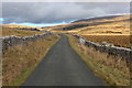
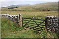
markj99 visited on 6th Apr 2014 - their rating: Cond: 3 Amb: 4 Access: 3 There is a convenient lay by c. 100ft WNW of Apron Full of Stones at SD7065578918. If Kingsdale Beck is in spate there is a bridge c. 200ft N of a lay-by at SD7023078010. The cairn is c. 0.5 mile walk by the river from this point.
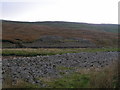
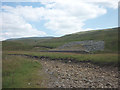
Apron Full of Stones is a much reduced cairn however there is sufficient original structure to suggest how impressive it would have been in its low lying landscape. The proximity of Yordas Cave is a bonus.
")
The stones forming the body of the cairn are graded in size with the larger stones towards the base of the structure. The use of gritstone and sandstone is unusual since the site stands on limestone. Construction of the monument seems to represent clearance of glacial stone deposits scattered over a considerable area, perhaps as part of farming activity. A small collection of flints suggested an early Bronze Age date. The low-lying location has led at least one archaeologist to suggest that it is not a cairn at all, but a small henge. The revetment wall below the cairn was built by the National Park Authority to prevent further stream erosion.
Source: Yorkshire Dales HER
You may be viewing yesterday's version of this page. To see the most up to date information please register for a free account.
")
")
")
")
Do not use the above information on other web sites or publications without permission of the contributor.
Nearby Images from Geograph Britain and Ireland:
©2005(licence)
©2013(licence)
©2016(licence)
©2011(licence)
©2011(licence)
The above images may not be of the site on this page, they are loaded from Geograph.
Please Submit an Image of this site or go out and take one for us!
Click here to see more info for this site
Nearby sites
Key: Red: member's photo, Blue: 3rd party photo, Yellow: other image, Green: no photo - please go there and take one, Grey: site destroyed
Download sites to:
KML (Google Earth)
GPX (GPS waypoints)
CSV (Garmin/Navman)
CSV (Excel)
To unlock full downloads you need to sign up as a Contributory Member. Otherwise downloads are limited to 50 sites.
Turn off the page maps and other distractions
Nearby sites listing. In the following links * = Image available
582m WNW 301° Yordas cave* Cave or Rock Shelter (SD704790)
3.1km S 185° Twisleton Scar* Rock Outcrop (SD70597563)
4.0km ESE 110° Keld Bank Settlement* Ancient Village or Settlement (SD74657734)
4.1km ESE 103° Philpin Sleights* Rock Outcrop (SD7486677760)
4.1km ESE 110° Keld Bank (Ingleborough)* Rock Art (SD7475977253)
4.8km E 94° Sleights Pasture Round Barrow* Round Cairn (SD75677836)
4.9km E 98° Sleights Pasture Propped Stone* Rock Outcrop (SD7579578018)
5.0km S 170° White Scars Cairn (SD717738)
5.3km E 87° Batty Wife Hole Ring Cairn (SD76227895)
5.3km SE 142° Ingleborough Camp* Hillfort (SD7419374511)
6.3km WSW 252° Leck Hall* Ancient Village or Settlement (SD64927677)
6.4km WNW 286° Brownthwaite Pike Round Cairn* Round Cairn (SD6477280479)
7.1km W 280° Casterton* Stone Circle (SD63937999)
8.6km ESE 117° Skirtful of Stones (Ingleborough) Cairn (SD785747)
9.0km WNW 291° Howerigg* Ancient Village or Settlement (SD62488192)
10.4km SSE 146° Norber Erratics Natural Stone / Erratic / Other Natural Feature (SD76597003)
10.4km W 262° Sellet Bank Enclosure* Ancient Village or Settlement (SD60517733)
10.6km WSW 243° St John the Baptist (Tunstall)* Early Christian Sculptured Stone (SD6141473925)
12.6km W 271° Gallowber Lane Romano-British Settlement/Enclosure* Ancient Village or Settlement (SD5823678908)
13.0km SSW 197° The Great Stone Of Fourstones* Natural Stone / Erratic / Other Natural Feature (SD6697266292)
13.4km SW 235° St Wilfrid (Melling)* Ancient Cross (SD5978571115)
13.8km SE 146° Feizor (Lawkland) Standing Stone (Menhir) (SD78586718)
13.8km ENE 64° Old Wife's Spring (Snaizeholme) Holy Well or Sacred Spring (SD834847)
13.9km SSW 198° Ringstones (Lowgill) Stone Circle (SD664655)
14.0km W 268° Hutton Roof Crag perched Limestone Boulder* Natural Stone / Erratic / Other Natural Feature (SD5686878268)
View more nearby sites and additional images


 We would like to know more about this location. Please feel free to add a brief description and any relevant information in your own language.
 Wir möchten mehr über diese Stätte erfahren. Bitte zögern Sie nicht, eine kurze Beschreibung und relevante Informationen in Deutsch hinzuzufügen.
 Nous aimerions en savoir encore un peu sur les lieux. S'il vous plaît n'hesitez pas à ajouter une courte description et tous les renseignements pertinents dans votre propre langue.
 Quisieramos informarnos un poco más de las lugares. No dude en añadir una breve descripción y otros datos relevantes en su propio idioma.