<< Our Photo Pages >> Came Down - Barrow Cemetery in England in Dorset
Submitted by TimPrevett on Tuesday, 24 May 2005 Page Views: 6513
Neolithic and Bronze AgeSite Name: Came DownCountry: England County: Dorset Type: Barrow Cemetery
Nearest Town: Dorchester Nearest Village: Upwey
Map Ref: SY687863
Latitude: 50.675514N Longitude: 2.44433W
Condition:
| 5 | Perfect |
| 4 | Almost Perfect |
| 3 | Reasonable but with some damage |
| 2 | Ruined but still recognisable as an ancient site |
| 1 | Pretty much destroyed, possibly visible as crop marks |
| 0 | No data. |
| -1 | Completely destroyed |
| 5 | Superb |
| 4 | Good |
| 3 | Ordinary |
| 2 | Not Good |
| 1 | Awful |
| 0 | No data. |
| 5 | Can be driven to, probably with disabled access |
| 4 | Short walk on a footpath |
| 3 | Requiring a bit more of a walk |
| 2 | A long walk |
| 1 | In the middle of nowhere, a nightmare to find |
| 0 | No data. |
| 5 | co-ordinates taken by GPS or official recorded co-ordinates |
| 4 | co-ordinates scaled from a detailed map |
| 3 | co-ordinates scaled from a bad map |
| 2 | co-ordinates of the nearest village |
| 1 | co-ordinates of the nearest town |
| 0 | no data |
Internal Links:
External Links:
I have visited· I would like to visit
TimPrevett has visited here
")
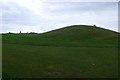
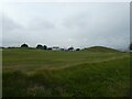
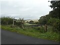
Several groups of barrows on Came Down - now a golf course.
You may be viewing yesterday's version of this page. To see the most up to date information please register for a free account.
")
Do not use the above information on other web sites or publications without permission of the contributor.
coldrum has found this location on Google Street View:
Nearby Images from Geograph Britain and Ireland:
©2007(licence)
©2020(licence)
©2020(licence)
©2008(licence)
©2020(licence)
The above images may not be of the site on this page, they are loaded from Geograph.
Please Submit an Image of this site or go out and take one for us!
Click here to see more info for this site
Nearby sites
Key: Red: member's photo, Blue: 3rd party photo, Yellow: other image, Green: no photo - please go there and take one, Grey: site destroyed
Download sites to:
KML (Google Earth)
GPX (GPS waypoints)
CSV (Garmin/Navman)
CSV (Excel)
To unlock full downloads you need to sign up as a Contributory Member. Otherwise downloads are limited to 50 sites.
Turn off the page maps and other distractions
Nearby sites listing. In the following links * = Image available
760m WSW 246° Winterborne Came 18b (Bincombe) Cairn (SY680860)
998m SW 233° Bincombe Down* Barrow Cemetery (SY679857)
1.3km ESE 112° Whitcombe 1* Long Barrow (SY699858)
1.6km WSW 251° Ridgeway Hill* Barrow Cemetery (SY672858)
1.6km S 173° Bincombe Barrows* Barrow Cemetery (SY689847)
1.8km ESE 123° Broadmayne Bank Barrow* Long Barrow (SY702853)
2.1km N 353° Herringston Bowl Barrow* Round Barrow(s) (SY68478842)
2.1km N 355° Herringston Long Barrow* Long Barrow (SY68548844)
2.4km W 277° Upwey Ridgeway* Barrow Cemetery (SY66298659)
2.6km SE 125° Northdown (Dorset)* Barrow Cemetery (SY708848)
2.6km SSE 162° Chalbury* Hillfort (SY695838)
2.8km WNW 288° Ashton Farm Bowl Barrows Barrow Cemetery (SY66088717)
2.8km NNE 21° Conygar Hill Barrows* Barrow Cemetery (SY697889)
2.8km NW 321° Maiden Castle Causewayed Enclosure* Causewayed Enclosure (SY66938848)
2.8km NW 320° Maiden Castle (Dorset)* Hillfort (SY66908846)
2.8km WSW 247° Upwey Wishing Well* Holy Well or Sacred Spring (SY661852)
2.8km NW 321° Maiden Castle Bank Barrow* Long Barrow (SY66928850)
3.3km NW 318° Maiden Castle Long Barrow 1 Long Barrow (SY66518879)
3.3km NW 325° Maiden Castle Linear Earthwork Misc. Earthwork (SY66798902)
3.4km ENE 78° Little Mayne* Stone Circle (SY720870)
3.5km NW 324° Lanceborough Enclosure Misc. Earthwork (SY66658920)
3.6km NW 326° Maiden Castle Barrow Cemetery* Barrow Cemetery (SY66698927)
3.6km NE 56° Whitcombe* Standing Stone (Menhir) (SY717883)
3.6km N 5° Maumbury Rings* Henge (SY69018992)
3.7km NW 325° Maiden Castle Long Barrow 2 Long Barrow (SY66578938)
View more nearby sites and additional images


 We would like to know more about this location. Please feel free to add a brief description and any relevant information in your own language.
 Wir möchten mehr über diese Stätte erfahren. Bitte zögern Sie nicht, eine kurze Beschreibung und relevante Informationen in Deutsch hinzuzufügen.
 Nous aimerions en savoir encore un peu sur les lieux. S'il vous plaît n'hesitez pas à ajouter une courte description et tous les renseignements pertinents dans votre propre langue.
 Quisieramos informarnos un poco más de las lugares. No dude en añadir una breve descripción y otros datos relevantes en su propio idioma.