


<< Our Photo Pages >> Pitglassie - Stone Circle in Scotland in Aberdeenshire
Submitted by Andy B on Monday, 15 July 2002 Page Views: 7748
Neolithic and Bronze AgeSite Name: PitglassieCountry: Scotland County: Aberdeenshire Type: Stone Circle
Map Ref: NJ686434 Landranger Map Number: 29
Latitude: 57.479752N Longitude: 2.525288W
Condition:
| 5 | Perfect |
| 4 | Almost Perfect |
| 3 | Reasonable but with some damage |
| 2 | Ruined but still recognisable as an ancient site |
| 1 | Pretty much destroyed, possibly visible as crop marks |
| 0 | No data. |
| -1 | Completely destroyed |
| 5 | Superb |
| 4 | Good |
| 3 | Ordinary |
| 2 | Not Good |
| 1 | Awful |
| 0 | No data. |
| 5 | Can be driven to, probably with disabled access |
| 4 | Short walk on a footpath |
| 3 | Requiring a bit more of a walk |
| 2 | A long walk |
| 1 | In the middle of nowhere, a nightmare to find |
| 0 | No data. |
| 5 | co-ordinates taken by GPS or official recorded co-ordinates |
| 4 | co-ordinates scaled from a detailed map |
| 3 | co-ordinates scaled from a bad map |
| 2 | co-ordinates of the nearest village |
| 1 | co-ordinates of the nearest town |
| 0 | no data |
Internal Links:
External Links:
I have visited· I would like to visit
Klingon has visited here
")
Have you visited this site? Please contribute a description or any thoughts by adding a comment.
You may be viewing yesterday's version of this page. To see the most up to date information please register for a free account.
Do not use the above information on other web sites or publications without permission of the contributor.
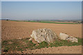
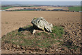
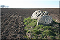
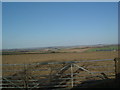
Nearby Images from Geograph Britain and Ireland:
©2015(licence)
©2015(licence)
©2015(licence)
©2008(licence)
©2015(licence)
The above images may not be of the site on this page, they are loaded from Geograph.
Please Submit an Image of this site or go out and take one for us!
Click here to see more info for this site
Nearby sites
Key: Red: member's photo, Blue: 3rd party photo, Yellow: other image, Green: no photo - please go there and take one, Grey: site destroyed
Download sites to:
KML (Google Earth)
GPX (GPS waypoints)
CSV (Garmin/Navman)
CSV (Excel)
To unlock full downloads you need to sign up as a Contributory Member. Otherwise downloads are limited to 50 sites.
Turn off the page maps and other distractions
Nearby sites listing. In the following links * = Image available
1.6km ESE 122° Mains Of Hatton* Stone Circle (NJ6993842537)
2.1km NNW 328° Greymuir Cairn* Stone Circle (NJ675452)
2.2km W 281° The Harestanes (Feith Hill)* Stone Circle (NJ6646043833)
2.4km ENE 62° Corrydown* Stone Circle (NJ707445)
3.1km NNW 340° Shielburn* Stone Circle (NJ6757646336)
3.2km NNW 336° Backhill Of Drachlaw* Stone Circle (NJ67294633)
3.4km NNW 339° Cairn Riv* Stone Circle (NJ6743546572)
4.1km SSW 192° Upper Third* Stone Circle (NJ6774839395)
4.2km E 101° Chapel Well (Aberdeenshire)* Holy Well or Sacred Spring (NJ727426)
4.8km N 351° Milnbank* Standing Stone (Menhir) (NJ67914818)
5.1km SW 214° Logie Newton NE* Stone Circle (NJ657392)
5.2km SW 214° Logie Newton SW* Stone Circle (NJ65653915)
5.4km S 186° West Haughs Stone Circle (NJ680380)
6.0km ESE 121° Burreldales (Rappla Wood)* Stone Circle (NJ737403)
6.2km WNW 285° Conwath Stone (Inverkeithny) Standing Stone (Menhir) (NJ62654507)
6.7km W 272° Raich Stone Circle* Stone Circle (NJ6187543655)
7.0km N 353° Cairn Ennit* Stone Circle (NJ678504)
7.1km NNE 17° Boat of Muiresk Ancient Village or Settlement (NJ707502)
7.1km N 353° Whitehill Wood* Stone Circle (NJ6781750510)
7.5km NNE 29° Turriff* Class I Pictish Symbol Stone (NJ72304991)
7.5km W 265° Frendraught* Stone Circle (NJ6110442869)
8.2km SW 215° Hillhead (Forgue) Stone Circle (NJ638367)
8.8km WNW 285° Yonder Bognie* Stone Circle (NJ601458)
8.9km N 11° Haughs of Ashogle Ancient Village or Settlement (NJ703521)
9.8km S 178° Black Cairn, Hill of Rothmaise* Cairn (NJ68823362)
View more nearby sites and additional images


 We would like to know more about this location. Please feel free to add a brief description and any relevant information in your own language.
 Wir möchten mehr über diese Stätte erfahren. Bitte zögern Sie nicht, eine kurze Beschreibung und relevante Informationen in Deutsch hinzuzufügen.
 Nous aimerions en savoir encore un peu sur les lieux. S'il vous plaît n'hesitez pas à ajouter une courte description et tous les renseignements pertinents dans votre propre langue.
 Quisieramos informarnos un poco más de las lugares. No dude en añadir una breve descripción y otros datos relevantes en su propio idioma.