<< Our Photo Pages >> Stanford Bishop Church Stone - Standing Stone (Menhir) in England in Herefordshire
Submitted by hamish on Friday, 17 November 2006 Page Views: 10252
Neolithic and Bronze AgeSite Name: Stanford Bishop Church StoneCountry: England
NOTE: This site is 5.939 km away from the location you searched for.
County: Herefordshire Type: Standing Stone (Menhir)
Nearest Town: Hereford Nearest Village: Stanford Bishop
Map Ref: SO682515
Latitude: 52.160849N Longitude: 2.466288W
Condition:
| 5 | Perfect |
| 4 | Almost Perfect |
| 3 | Reasonable but with some damage |
| 2 | Ruined but still recognisable as an ancient site |
| 1 | Pretty much destroyed, possibly visible as crop marks |
| 0 | No data. |
| -1 | Completely destroyed |
| 5 | Superb |
| 4 | Good |
| 3 | Ordinary |
| 2 | Not Good |
| 1 | Awful |
| 0 | No data. |
| 5 | Can be driven to, probably with disabled access |
| 4 | Short walk on a footpath |
| 3 | Requiring a bit more of a walk |
| 2 | A long walk |
| 1 | In the middle of nowhere, a nightmare to find |
| 0 | No data. |
| 5 | co-ordinates taken by GPS or official recorded co-ordinates |
| 4 | co-ordinates scaled from a detailed map |
| 3 | co-ordinates scaled from a bad map |
| 2 | co-ordinates of the nearest village |
| 1 | co-ordinates of the nearest town |
| 0 | no data |
Internal Links:
External Links:
I have visited· I would like to visit
hamish has visited here
")
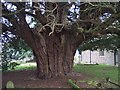
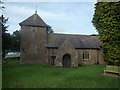
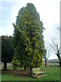
In the churchyard is a very old Yew tree authoritatively estimated at 1200 years. Inside the Church is a very old chair said to be the one that St Augustine was seated at the second Synod AD 603. (Probably not authentic)
You may be viewing yesterday's version of this page. To see the most up to date information please register for a free account.
")
Do not use the above information on other web sites or publications without permission of the contributor.
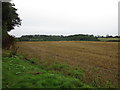
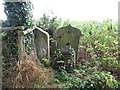
Nearby Images from Geograph Britain and Ireland:
©2006(licence)
©2016(licence)
©2020(licence)
©2016(licence)
©2020(licence)
The above images may not be of the site on this page, they are loaded from Geograph.
Please Submit an Image of this site or go out and take one for us!
Click here to see more info for this site
Nearby sites
Key: Red: member's photo, Blue: 3rd party photo, Yellow: other image, Green: no photo - please go there and take one, Grey: site destroyed
Download sites to:
KML (Google Earth)
GPX (GPS waypoints)
CSV (Garmin/Navman)
CSV (Excel)
To unlock full downloads you need to sign up as a Contributory Member. Otherwise downloads are limited to 50 sites.
Turn off the page maps and other distractions
Nearby sites listing. In the following links * = Image available
8.2km S 171° Bosbury Church Stone* Standing Stone (Menhir) (SO695434)
9.3km NE 41° The Berrow* Hillfort (SO744585)
10.7km ESE 122° St Ann's Well (Great Malvern)* Holy Well or Sacred Spring (SO77234579)
12.0km NNW 329° Garmsley Camp* Hillfort (SO620618)
12.7km SE 136° Holy Well (Malvern)* Holy Well or Sacred Spring (SO770423)
12.7km SE 137° Jubilee Hill barrow* Round Barrow(s) (SO768421)
13.1km WNW 301° Uphampton Camp Hillfort (SO57005838)
13.3km S 175° Wall Hills Camp* Hillfort (SO692382)
13.4km SW 215° St Edith's Well (Herefordshire)* Holy Well or Sacred Spring (SO604406)
13.5km S 176° Redhill Wood Hillfort* Hillfort (SO690380)
13.8km SE 146° Herefordshire Beacon* Hillfort (SO75974003)
14.5km WNW 285° Risbury Camp* Hillfort (SO542554)
14.5km SSE 147° Walms Well* Holy Well or Sacred Spring (SO76053927)
14.6km NNE 27° Woodbury Hill (Worcestershire)* Hillfort (SO749645)
15.7km WNW 287° Blackwardine Crossroads* Modern Stone Circle etc (SO5318656161)
15.8km SW 217° Backbury* Hillfort (SO587389)
16.1km SSE 150° Midsummer Hill* Hillfort (SO761375)
16.1km WNW 302° Bach Camp* Hillfort (SO546602)
16.2km W 271° Dinmore Hill Hillfort (SO520519)
16.5km WSW 252° Sutton Walls* Hillfort (SO525464)
16.7km E 98° Kempsey Cross* Ancient Cross (SO8482149096)
16.9km WSW 243° The Wergin's Stone* Standing Stone (Menhir) (SO5297543981)
17.5km WSW 255° St Ethelbert's Well (Marden)* Holy Well or Sacred Spring (SO512471)
18.1km SSE 167° Haffield Camp* Hillfort (SO72303390)
19.0km NNW 332° St Mary's Church cross fragment* Ancient Cross (SO5944268368)
View more nearby sites and additional images


 We would like to know more about this location. Please feel free to add a brief description and any relevant information in your own language.
 Wir möchten mehr über diese Stätte erfahren. Bitte zögern Sie nicht, eine kurze Beschreibung und relevante Informationen in Deutsch hinzuzufügen.
 Nous aimerions en savoir encore un peu sur les lieux. S'il vous plaît n'hesitez pas à ajouter une courte description et tous les renseignements pertinents dans votre propre langue.
 Quisieramos informarnos un poco más de las lugares. No dude en añadir una breve descripción y otros datos relevantes en su propio idioma.