


<< Our Photo Pages >> Els Ness Megalithic Cemetery - Barrow Cemetery in Scotland in Orkney
Submitted by DrewParsons on Monday, 18 October 2010 Page Views: 5102
Neolithic and Bronze AgeSite Name: Els Ness Megalithic Cemetery Alternative Name: Elsness Megalithic CemerteryCountry: Scotland County: Orkney Type: Barrow Cemetery
Nearest Town: Sanday Island Nearest Village: Lady
Map Ref: HY67583746
Latitude: 59.222508N Longitude: 2.5697W
Condition:
| 5 | Perfect |
| 4 | Almost Perfect |
| 3 | Reasonable but with some damage |
| 2 | Ruined but still recognisable as an ancient site |
| 1 | Pretty much destroyed, possibly visible as crop marks |
| 0 | No data. |
| -1 | Completely destroyed |
| 5 | Superb |
| 4 | Good |
| 3 | Ordinary |
| 2 | Not Good |
| 1 | Awful |
| 0 | No data. |
| 5 | Can be driven to, probably with disabled access |
| 4 | Short walk on a footpath |
| 3 | Requiring a bit more of a walk |
| 2 | A long walk |
| 1 | In the middle of nowhere, a nightmare to find |
| 0 | No data. |
| 5 | co-ordinates taken by GPS or official recorded co-ordinates |
| 4 | co-ordinates scaled from a detailed map |
| 3 | co-ordinates scaled from a bad map |
| 2 | co-ordinates of the nearest village |
| 1 | co-ordinates of the nearest town |
| 0 | no data |
Internal Links:
External Links:
I have visited· I would like to visit
whese001 would like to visit
DrewParsons has visited here
")
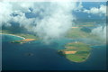
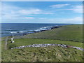
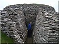
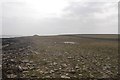
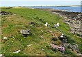
This megalithic cemetery is located on the Els Ness Peninsula south of Quoyness Chambered Cairn and near Augmund Howe Cairn on Sanday Island. There is a semi circle of cairns westwards from Augmund Howe Cairn with many others further afield on the southern end of this peninsula making it an important prehistoric burial site. The cairns are unexcavated but thought to be Bronze Age burials. Nowadays it is hard to pick out the individual cairns unless you walk the area looking carefully. The grid reference given is for the one in the photo that I have submitted which is south west of Augmund Howe Cairn.
You may be viewing yesterday's version of this page. To see the most up to date information please register for a free account.
")
")
")
Do not use the above information on other web sites or publications without permission of the contributor.
Nearby Images from Geograph Britain and Ireland:
©2018(licence)
©2015(licence)
©2006(licence)
©2018(licence)
©2010(licence)
The above images may not be of the site on this page, they are loaded from Geograph.
Please Submit an Image of this site or go out and take one for us!
Click here to see more info for this site
Nearby sites
Key: Red: member's photo, Blue: 3rd party photo, Yellow: other image, Green: no photo - please go there and take one, Grey: site destroyed
Download sites to:
KML (Google Earth)
GPX (GPS waypoints)
CSV (Garmin/Navman)
CSV (Excel)
To unlock full downloads you need to sign up as a Contributory Member. Otherwise downloads are limited to 50 sites.
Turn off the page maps and other distractions
Nearby sites listing. In the following links * = Image available
92m NE 40° Augmund Howe* Cairn (HY67643753)
339m NNE 13° Quoyness Barrow* Chambered Cairn (HY67663779)
3.4km E 81° Broch of Wasso Broch or Nuraghe (HY70923794)
3.5km E 89° Tresness Cairn* Chambered Cairn (HY71093747)
3.6km NE 52° Tresness Bronze Age Village* Ancient Village or Settlement (HY7048939660)
3.6km E 81° Hangie Head Broch or Nuraghe (HY712380)
3.7km NNE 17° Meur Burnt Mound* Artificial Mound (HY6870541013)
4.3km NNW 329° Marygarth Manse Broch or Nuraghe (HY654412)
5.6km W 269° Braehowar Broch or Nuraghe (HY620374)
5.8km NNW 348° Hermisgarth (Sanday) Cairn (HY6641543124)
6.8km WSW 245° Hacksness (Sanday) Artificial Mound (HY61403464)
7.2km WSW 253° Loth Road Bronze Age Structure Ancient Village or Settlement (HY6067635354)
7.2km NNW 340° Rethie Taing (Sanday) Cairn (HY6512344241)
7.7km N 356° Stone of Scar* Natural Stone / Erratic / Other Natural Feature (HY6708345185)
7.9km SW 217° Holm of Huip (Stronsay) Cairn (HY62823116)
8.3km S 185° Earl's Knoll (Papa Stronsay) Cairn (HY66822920)
8.3km NNW 342° Whale Point (Sanday) Cairn (HY65114542)
9.0km S 182° Cutter's Tuo (Stronsay) Cairn (HY67252847)
9.7km W 276° Calf of Eday Southeast Chambered Cairn (HY57923852)
9.7km W 276° Calf of Eday, North West Round Cairn (HY57883858)
9.8km W 276° Calf of Eday (Long) Chambered Cairn (HY57863861)
10.7km SSW 196° Oram's Fancy Cists* Cist (HY64502718)
11.0km WSW 259° Withebeir (Eday) Artificial Mound (HY5676135375)
11.0km W 267° Mill Loch* Cairn (HY56513702)
11.1km W 268° Stone of Setter* Standing Stone (Menhir) (HY56453718)
View more nearby sites and additional images


 We would like to know more about this location. Please feel free to add a brief description and any relevant information in your own language.
 Wir möchten mehr über diese Stätte erfahren. Bitte zögern Sie nicht, eine kurze Beschreibung und relevante Informationen in Deutsch hinzuzufügen.
 Nous aimerions en savoir encore un peu sur les lieux. S'il vous plaît n'hesitez pas à ajouter une courte description et tous les renseignements pertinents dans votre propre langue.
 Quisieramos informarnos un poco más de las lugares. No dude en añadir una breve descripción y otros datos relevantes en su propio idioma.