<< Our Photo Pages >> The Great Stone Of Fourstones - Natural Stone / Erratic / Other Natural Feature in England in Yorkshire (North)
Submitted by Sunny100 on Wednesday, 09 June 2010 Page Views: 17699
Natural PlacesSite Name: The Great Stone Of Fourstones Alternative Name: The Great Stone; Fourstone Boulder; Four StonesCountry: England
NOTE: This site is 2.5 km away from the location you searched for.
County: Yorkshire (North) Type: Natural Stone / Erratic / Other Natural Feature
Nearest Town: Bentham Nearest Village: Fourstones
Map Ref: SD6697266292
Latitude: 54.091465N Longitude: 2.506451W
Condition:
| 5 | Perfect |
| 4 | Almost Perfect |
| 3 | Reasonable but with some damage |
| 2 | Ruined but still recognisable as an ancient site |
| 1 | Pretty much destroyed, possibly visible as crop marks |
| 0 | No data. |
| -1 | Completely destroyed |
| 5 | Superb |
| 4 | Good |
| 3 | Ordinary |
| 2 | Not Good |
| 1 | Awful |
| 0 | No data. |
| 5 | Can be driven to, probably with disabled access |
| 4 | Short walk on a footpath |
| 3 | Requiring a bit more of a walk |
| 2 | A long walk |
| 1 | In the middle of nowhere, a nightmare to find |
| 0 | No data. |
| 5 | co-ordinates taken by GPS or official recorded co-ordinates |
| 4 | co-ordinates scaled from a detailed map |
| 3 | co-ordinates scaled from a bad map |
| 2 | co-ordinates of the nearest village |
| 1 | co-ordinates of the nearest town |
| 0 | no data |
Internal Links:
External Links:
I have visited· I would like to visit
SimonBlackmore would like to visit
Hordernm visited on 25th Jul 2023 - their rating: Cond: 5 Amb: 5 Access: 4
cactus_chris visited on 24th Jun 2020 - their rating: Cond: 5 Amb: 5 Access: 4
SumDoood visited on 10th Jan 2018 - their rating: Cond: 3 Amb: 3 Access: 4 Zoom in using Bing’s aerial view and you will see, close to the big stone, a big enough boggy hole in the ground to the North, and one at 1 o’clock, and another at 2 o’clock. I’ll dare to suggest that they might indicate where the missing three stones once stood.
Interesting too is the track immediately on the west side of the Great Stone. To the south it becomes one track which seems to continue on across Aikengill Road, then swing west to join that same road c. 200m away, and to swing east then south to continue generally towards the farm known as Sea View on Ringstones Lane (and there’s a name to ponder on!). North of the Great Stone the “dual carriageway” of tracks spreads like fingers through the boggy ground, but the walker here will find that generally the path curves towards Fourstones Barn and continues north-ish from there. It seems quite possible that the track(s) described in this paragraph were the forerunners of the modern Slaidburn Road.
coin visited - their rating: Cond: 4 Amb: 4 Access: 4
FrothNinja have visited here
Average ratings for this site from all visit loggers: Condition: 4.25 Ambience: 4.25 Access: 4

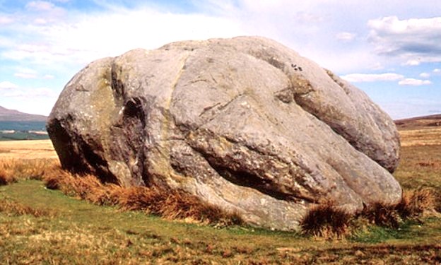
The great boulder was probably deposited here at the end of the last Ice Age, sometime between 10,000 to 15,000 years ago, or maybe an earlier glacial retreat. The boulder is a much visited attraction. It is marked on the OS maps. Certainly worth a visit, if you enjoy a long walk on the moors.
Brigantia writes: Harry Speight (1892) told how the (original) Four Stones were the creation of our old mate the Devil, long ago, who dropped them in one his many megalithic travels across our land. The stones were also the meeting place of ancient councils, from the tribes either side of the Yorkshire-Lancashire border. Their presence here also had mythic relationship with the Queen of the Fairies Chair, about a mile southeast, along the same boundary line.
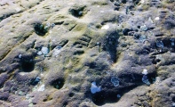
Apparently also has possible rock art.
Pastscape Monument No. 589030 has a very brief entry for this site, classifying it as a boundary stone.
The Northern Antiquarian (TNA) also feature a page for this legendary stone - see their entry for Great Stone of Fourstones, Lowgill, North Yorkshire, which contains directions for finding this site together with photographs, a brief archaeology & history, local folklore and the 1847 OS map showing the location of this stone.
You may be viewing yesterday's version of this page. To see the most up to date information please register for a free account.


Do not use the above information on other web sites or publications without permission of the contributor.
Click here to see more info for this site
Nearby sites
Key: Red: member's photo, Blue: 3rd party photo, Yellow: other image, Green: no photo - please go there and take one, Grey: site destroyed
Download sites to:
KML (Google Earth)
GPX (GPS waypoints)
CSV (Garmin/Navman)
CSV (Excel)
To unlock full downloads you need to sign up as a Contributory Member. Otherwise downloads are limited to 50 sites.
Turn off the page maps and other distractions
Nearby sites listing. In the following links * = Image available
976m SW 215° Ringstones (Lowgill) Stone Circle (SD664655)
6.3km WNW 290° Tatham Enclosure* Ancient Village or Settlement (SD61086846)
7.0km WSW 259° Roeburndale stone circle* Modern Stone Circle etc (SD60086496)
8.6km WNW 304° St Wilfrid (Melling)* Ancient Cross (SD5978571115)
8.8km WNW 285° St Margaret (Hornby)* Ancient Cross (SD5847068580)
8.9km NNE 32° White Scars Cairn (SD717738)
9.4km WNW 291° Castle Stede Hillfort (SD582697)
9.4km NW 324° St John the Baptist (Tunstall)* Early Christian Sculptured Stone (SD6141473925)
10.0km NNE 21° Twisleton Scar* Rock Outcrop (SD70597563)
10.3km ENE 68° Norber Erratics Natural Stone / Erratic / Other Natural Feature (SD76597003)
10.3km WNW 290° St John the Evangelist (Gressingham)* Ancient Cross (SD5725069915)
10.5km SE 124° Brown Hills Beck* Round Barrow(s) (SD75616035)
10.6km SE 124° Brown Hills Beck East* Round Barrow(s) (SD75656025)
10.7km NNW 349° Leck Hall* Ancient Village or Settlement (SD64927677)
10.9km NE 41° Ingleborough Camp* Hillfort (SD7419374511)
11.6km E 85° Feizor (Lawkland) Standing Stone (Menhir) (SD78586718)
12.8km NNW 329° Sellet Bank Enclosure* Ancient Village or Settlement (SD60517733)
12.8km E 84° Feizor Thwaite (Lawkland) Ring Cairn (SD79796747)
13.0km NNE 17° Apron Full of Stones* Ring Cairn (SD709787)
13.1km E 85° Feizor Celtic Wall* Misc. Earthwork (SD8008067386)
13.2km NNE 15° Yordas cave* Cave or Rock Shelter (SD704790)
13.4km E 93° The Ebbing and Flowing Well* Holy Well or Sacred Spring (SD80396538)
13.4km NE 35° Keld Bank (Ingleborough)* Rock Art (SD7475977253)
13.4km NE 34° Keld Bank Settlement* Ancient Village or Settlement (SD74657734)
13.5km E 89° Sheep Scar Circle (Giggleswick) Ring Cairn (SD8051366473)
View more nearby sites and additional images


 We would like to know more about this location. Please feel free to add a brief description and any relevant information in your own language.
 Wir möchten mehr über diese Stätte erfahren. Bitte zögern Sie nicht, eine kurze Beschreibung und relevante Informationen in Deutsch hinzuzufügen.
 Nous aimerions en savoir encore un peu sur les lieux. S'il vous plaît n'hesitez pas à ajouter une courte description et tous les renseignements pertinents dans votre propre langue.
 Quisieramos informarnos un poco más de las lugares. No dude en añadir una breve descripción y otros datos relevantes en su propio idioma.