<< Our Photo Pages >> The Trendle - Misc. Earthwork in England in Dorset
Submitted by coldrum on Monday, 04 January 2010 Page Views: 8315
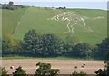
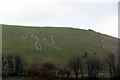
Multi-periodSite Name: The Trendle Alternative Name: The Frying PanCountry: England County: Dorset Type: Misc. Earthwork
Nearest Village: Cerne Abbas
Map Ref: ST66730167
Latitude: 50.813616N Longitude: 2.473602W
Condition:
| 5 | Perfect |
| 4 | Almost Perfect |
| 3 | Reasonable but with some damage |
| 2 | Ruined but still recognisable as an ancient site |
| 1 | Pretty much destroyed, possibly visible as crop marks |
| 0 | No data. |
| -1 | Completely destroyed |
| 5 | Superb |
| 4 | Good |
| 3 | Ordinary |
| 2 | Not Good |
| 1 | Awful |
| 0 | No data. |
| 5 | Can be driven to, probably with disabled access |
| 4 | Short walk on a footpath |
| 3 | Requiring a bit more of a walk |
| 2 | A long walk |
| 1 | In the middle of nowhere, a nightmare to find |
| 0 | No data. |
| 5 | co-ordinates taken by GPS or official recorded co-ordinates |
| 4 | co-ordinates scaled from a detailed map |
| 3 | co-ordinates scaled from a bad map |
| 2 | co-ordinates of the nearest village |
| 1 | co-ordinates of the nearest town |
| 0 | no data |
Internal Links:
External Links:
I have visited· I would like to visit
LouRock would like to visit
")
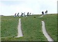
The following information comes from the Pastscape site: "Earthwork, called the Trendle, forms a roughly rectangular enclosure, it consists of an outer bank with a slight outer ditch on the N and E and an inner bank with a slight inner ditch. The inner bank is of sharper profile and more regular form and is presumably of later date; it is indeed stated to have been a hedge-bank (Antiquity, IV, 113). Within the enclosure is a rise in the ground of quite irregular form. The enclosure is said to have been used for Maypole dancing.
(2) Possibly Romano-British, associated with the Cerne Giant (ST 60 SE 39).
(3) "The Trendle" or "Frying Pan"; a small banked enclosure measuring 30.5 m by 27.4 m with a raised disturbed centre. It may represent an Iron Age burial mound, the tomb perhaps of the person represented by the 'Giant'.
(4) Situated at ST 66730167, terraced into the S end of a N-S spur immediately above and E of the Cerne Abbas Giant, lies a well preserved rectangular earthwork. The area enclosed measures 23.0 m NW-SW by 19.0m NW-SE, and is a level platform cut into the slope. For such a small earthwork the system of banks and ditches is complex. They consists of an outer ditch 0.3 m deep, intact around the N side only, but traceable around the W and E. Inside this is a substantial bank 1.8 m high on the downhill S side, and 1.5 m on the uphill N side broken by a possible entrance in the S corner. A second continuous bank runs parallel to, and inside of, the above, averaging 0.6 m high and 2.0 m wide with traces of a vestigial inner ditch 0.2 m deep. Roughly central to the enclosure and orientated E-W lies a rectangular mound, 15.0 m long by 10.0 m wide, and up to 0.7 m high. Without excavation, it is impossible to conclude the age and purpose of this feature. However, some form of ritualistic origin seems likely. Surveyed at 1:2500 on MSD with 1:1250 enlargement.
(5) The earthwork is known locally as "Frying Pan". Enquiries to establish the application of the name 'Trendle' to the feature were negative. Mrs Fox (b) a life long, and now also the oldest inhabitant of Cerne Abbas, stated that she had never heard of the name 'Trendle' being applied specifically to the enclosure, but rather it seems to some vague indeterminable area of Giant Hill"
You may be viewing yesterday's version of this page. To see the most up to date information please register for a free account.
")
")
Do not use the above information on other web sites or publications without permission of the contributor.
Nearby Images from Geograph Britain and Ireland:
©2008(licence)
©2012(licence)
©2012(licence)
©2008(licence)
©2008(licence)
The above images may not be of the site on this page, they are loaded from Geograph.
Please Submit an Image of this site or go out and take one for us!
Click here to see more info for this site
Nearby sites
Key: Red: member's photo, Blue: 3rd party photo, Yellow: other image, Green: no photo - please go there and take one, Grey: site destroyed
Download sites to:
KML (Google Earth)
GPX (GPS waypoints)
CSV (Garmin/Navman)
CSV (Excel)
To unlock full downloads you need to sign up as a Contributory Member. Otherwise downloads are limited to 50 sites.
Turn off the page maps and other distractions
Nearby sites listing. In the following links * = Image available
71m W 278° Cerne Abbas Giant* Hill Figure or Geoglyph (ST66660168)
133m NNW 347° Giant Hill Cross Ridge Dyke Misc. Earthwork (ST667018)
202m N 8° Giant Hill Bowl Barrow Round Barrow(s) (ST66760187)
314m SSW 196° St Augustine's Well (Cerne Abbas)* Holy Well or Sacred Spring (ST6664001369)
620m NNE 20° Giant Hill Settlement Ancient Village or Settlement (ST66950225)
688m NNE 25° Bowl Barrow (Dorset) Round Barrow(s) (ST67030229)
1.0km ESE 105° Alton Lane Field System Misc. Earthwork (ST677014)
1.3km SSE 158° Black Hill Farm Enclosure Ancient Village or Settlement (ST672005)
1.3km W 267° Weam Commen Hill Field System Misc. Earthwork (ST654016)
1.6km SSE 156° Oxencombe Bottom Bowl Barrow Round Barrow(s) (ST67380018)
1.8km WNW 292° Seldon Hill Settlement Ancient Village or Settlement (ST65100235)
1.8km SW 217° Dickley Hill Settlement Ancient Village or Settlement (ST65650027)
1.8km SW 218° Dickley Hill Bowl Barrows Round Barrow(s) (ST65600026)
1.8km NW 326° High Cank Henge Henge (ST65720319)
1.9km NNW 333° Farm Hill Bowl Barrow Round Barrow(s) (ST65880334)
2.0km W 279° Wancombe Hill Field System Misc. Earthwork (ST64790200)
2.3km S 171° Green Hill Barrows Barrow Cemetery (SY67069943)
2.3km WSW 247° Up Cerne/Sydling St Nicholas Boundary Stone* Marker Stone (ST64610078)
2.4km SSW 201° Smacam Down Bowl Barrow Round Barrow(s) (SY65859946)
2.4km SSE 168° Green Hill Field System Misc. Earthwork (SY672993)
2.5km SSW 203° Smacam Down Long Barrow Long Barrow (SY6572599389)
2.5km SSW 204° Smacam Down Settlement Ancient Village or Settlement (SY657994)
2.8km NNW 328° East Hill field System* Misc. Earthwork (ST65250405)
3.4km NNW 331° St Mary's Well (Hermitage)* Holy Well or Sacred Spring (ST651047)
3.8km SSW 194° Nether Cerne Field System Misc. Earthwork (SY658980)
View more nearby sites and additional images


 We would like to know more about this location. Please feel free to add a brief description and any relevant information in your own language.
 Wir möchten mehr über diese Stätte erfahren. Bitte zögern Sie nicht, eine kurze Beschreibung und relevante Informationen in Deutsch hinzuzufügen.
 Nous aimerions en savoir encore un peu sur les lieux. S'il vous plaît n'hesitez pas à ajouter une courte description et tous les renseignements pertinents dans votre propre langue.
 Quisieramos informarnos un poco más de las lugares. No dude en añadir una breve descripción y otros datos relevantes en su propio idioma.