<< Our Photo Pages >> Yadlee - Stone Circle in Scotland in East Lothian
Submitted by minteddy on Wednesday, 14 February 2018 Page Views: 12807
Neolithic and Bronze AgeSite Name: YadleeCountry: Scotland County: East Lothian Type: Stone Circle
Nearest Village: Cranshaws
Map Ref: NT65406732 Landranger Map Number: 67
Latitude: 55.897751N Longitude: 2.554874W
Condition:
| 5 | Perfect |
| 4 | Almost Perfect |
| 3 | Reasonable but with some damage |
| 2 | Ruined but still recognisable as an ancient site |
| 1 | Pretty much destroyed, possibly visible as crop marks |
| 0 | No data. |
| -1 | Completely destroyed |
| 5 | Superb |
| 4 | Good |
| 3 | Ordinary |
| 2 | Not Good |
| 1 | Awful |
| 0 | No data. |
| 5 | Can be driven to, probably with disabled access |
| 4 | Short walk on a footpath |
| 3 | Requiring a bit more of a walk |
| 2 | A long walk |
| 1 | In the middle of nowhere, a nightmare to find |
| 0 | No data. |
| 5 | co-ordinates taken by GPS or official recorded co-ordinates |
| 4 | co-ordinates scaled from a detailed map |
| 3 | co-ordinates scaled from a bad map |
| 2 | co-ordinates of the nearest village |
| 1 | co-ordinates of the nearest town |
| 0 | no data |
Internal Links:
External Links:
")
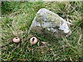
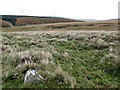
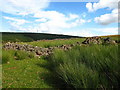
For information on the Neolithic/Bronze Age Stone Circle, see Canmore ID 57472 the most recent visit in 1979 reported: "This stone circle is situated on level though undulating moorland in an area of heather or pasture ... the stones describe an oval measuring overall 9.0m E-W by 8.0m N-S. The significance of four earthfast stones outside the northern arc and a random group of five others about 10.0m west of the circle is uncertain, but they do not appear to have formed part of a larger or more complex monument."
This 9m stone circle also features on the Ancient Stones website - see their entry for Stone Circle, Yadlee, Cranshaws, which includes a description, directions for finding this site together with nearby parking, folklore and fieldnotes. Ancient stones says "Although far from being a spectacular stone circle, this setting of small stones still has an air of mystery about it. Set in a desolate patch of open and windswept moorland, Yadlee Stone Circle makes you wonder about the people who took to time and effort to construct it in the first place. What rituals took place there? Why did they pick this location in the first place? .... Almost lost and almost forgotten, this small and simple stone circle still has some magic left."
Note: Details in our comments of a student project to survey and look for astronomical alignments at this petite stone circle - they found solar alignments with a suggested agricultural purpose
You may be viewing yesterday's version of this page. To see the most up to date information please register for a free account.
")
Do not use the above information on other web sites or publications without permission of the contributor.
Nearby Images from Geograph Britain and Ireland:
©2006(licence)
©2006(licence)
©2006(licence)
©2006(licence)
©2006(licence)
The above images may not be of the site on this page, they are loaded from Geograph.
Please Submit an Image of this site or go out and take one for us!
Click here to see more info for this site
Nearby sites
Key: Red: member's photo, Blue: 3rd party photo, Yellow: other image, Green: no photo - please go there and take one, Grey: site destroyed
Download sites to:
KML (Google Earth)
GPX (GPS waypoints)
CSV (Garmin/Navman)
CSV (Excel)
To unlock full downloads you need to sign up as a Contributory Member. Otherwise downloads are limited to 50 sites.
Turn off the page maps and other distractions
Nearby sites listing. In the following links * = Image available
1.4km WSW 257° Spartleton Edge Stone Circle (NT640670)
2.6km ESE 120° Bothwell Water (Cranshaws) Natural Stone / Erratic / Other Natural Feature (NT67656598)
3.1km WSW 258° Tavers Cleugh* Cairn (NT62386671)
3.2km SSW 202° Packman's Grave (Whiteadder Reservoir) Stone Row / Alignment (NT64176439)
3.3km SSW 198° Whiteadder Reservoir* Cairn (NT64336421)
3.3km SSW 195° Kell Burn Stone Circle (NT645641)
3.4km WSW 237° Nine Stones Rig* Stone Circle (NT62546549)
3.5km W 265° Ragstone Rig (Cranshaws) Stone Row / Alignment (NT61956705)
3.5km SW 232° Stone Standing Stone Standing Stone (Menhir) (NT62586518)
3.6km SW 230° Kingside Hill Stone Circle (NT62636503)
3.6km SW 222° Mayshiel Stone Circle* Stone Circle (NT62986465)
3.8km SW 215° Penshiel Hill Stone Circle (NT632642)
4.1km WSW 239° Crow Stones (Cranshaws)* Stone Circle (NT61836519)
4.2km WNW 287° White Castle Fort* Hillfort (NT61356860)
4.3km SSE 165° Kilmade Hillfort* Hillfort (NT66456315)
4.4km SSW 198° Penshiel Grange Stone Circle* Stone Circle (NT64016317)
4.4km SSW 198° Chapel Stone (Penshiel Grange)* Stone Circle (NT64016317)
4.6km SW 233° Mayshiel Stone Circle (NT617646)
7.7km NNW 337° Rood Well* Holy Well or Sacred Spring (NT6237674417)
8.0km N 10° Witches' Stone (Spott)* Holy Well or Sacred Spring (NT66917520)
8.5km NNE 12° St John's Well (Spott)* Holy Well or Sacred Spring (NT67277561)
8.8km NNE 21° Doon Hill Dunbar* Ancient Village or Settlement (NT6868775539)
8.9km SSW 200° Mutiny Stones* Cairn (NT62255902)
9.6km NNE 15° Easter Broomhouse* Standing Stone (Menhir) (NT6800876615)
9.9km NW 309° Standingstone (East Lothian)* Standing Stone (Menhir) (NT57737363)
View more nearby sites and additional images


 We would like to know more about this location. Please feel free to add a brief description and any relevant information in your own language.
 Wir möchten mehr über diese Stätte erfahren. Bitte zögern Sie nicht, eine kurze Beschreibung und relevante Informationen in Deutsch hinzuzufügen.
 Nous aimerions en savoir encore un peu sur les lieux. S'il vous plaît n'hesitez pas à ajouter une courte description et tous les renseignements pertinents dans votre propre langue.
 Quisieramos informarnos un poco más de las lugares. No dude en añadir una breve descripción y otros datos relevantes en su propio idioma.