Featured: Lost Secrets - an adventure during Neolithic times

Lost Secrets - an adventure during Neolithic times

Stonehenge Sacred Symbolism - Ancient Beliefs in Britain and Northern Europe

Stonehenge Sacred Symbolism - Ancient Beliefs in Britain and Northern Europe

Who's Online

There are currently, 150 guests and 0 members online.

You are a guest. To join in, please register for free by clicking here

Sponsors

<< Our Photo Pages >> The Wrekin - Hillfort in England in Shropshire

Submitted by TimPrevett on Monday, 30 March 2009  Page Views: 35186

Iron Age and Later PrehistorySite Name: The Wrekin Alternative Name: Cuckoo’s Cup, Raven’s Bowl
Country: England
NOTE: This site is 0.3 km away from the location you searched for.

County: Shropshire Type: Hillfort
Nearest Town: Telford
Map Ref: SJ630083  Landranger Map Number: 127
Latitude: 52.671136N  Longitude: 2.548604W
Condition:
5Perfect
4Almost Perfect
3Reasonable but with some damage
2Ruined but still recognisable as an ancient site
1Pretty much destroyed, possibly visible as crop marks
0No data.
-1Completely destroyed
3 Ambience:
5Superb
4Good
3Ordinary
2Not Good
1Awful
0No data.
5 Access:
5Can be driven to, probably with disabled access
4Short walk on a footpath
3Requiring a bit more of a walk
2A long walk
1In the middle of nowhere, a nightmare to find
0No data.
4 Accuracy:
5co-ordinates taken by GPS or official recorded co-ordinates
4co-ordinates scaled from a detailed map
3co-ordinates scaled from a bad map
2co-ordinates of the nearest village
1co-ordinates of the nearest town
0no data
3

Internal Links:
External Links:

I have visited· I would like to visit

Marko visited on 6th May 2017 - their rating: Cond: 4 Amb: 3 Access: 3

BrownEdger visited on 14th Aug 2011 - their rating: Cond: 3 Amb: 4

TimPrevett Serenstar have visited here

Average ratings for this site from all visit loggers: Condition: 3.5 Ambience: 3.5

The Wrekin
The Wrekin submitted by TimPrevett : Lookin to the North East, between the outer and inner ramparts of The Wrekin. The path enters the inturned ramparts to the central area; the trig point and toposcope sit upon a Bronze Age Cairn, which is hardly in evidence. Another, more slight rampart is visible to the left of the picture, before the hill becomes more rounded. See main entry - click on the blue text to the left of the pi... (Vote or comment on this photo)
Hillfort, Bronze Age barrow, Bronze Age cairn, Holy Well and possible calendar stone in Shropshire. The Wrekin is perhaps Shropshire’s most significant hillfort. Once home to the Cornovii a British tribe (originally from Iberia), the fort was stormed by the Romans under Ostorius Scapula around the spring of AD47.

Finds of pilum (javelin) heads, as well as signs of burning in the 1st century AD give this credence. The Wrekin, besides being the capital of The Cornovii at an imposing 1,300 feet above sea level, was of strategic importance.

This tribe governed a substantial area from the Midlands, up to the Wirral (perhaps where their name comes from – ‘Cornu’ the Roman horn, with the shape of the Wirral being arguably horn shaped), and in order to help launch a conquest of what is now Wales. Their economic strength, and their salt resources were also vital for the Romans to control - the Cornovii’s territory contained three of Britain’s four inland salt spas – Nantwich, Middlewich, and Northwich (the other being Droitwich in The Midlands).

The population, subsequent to Roman conquest, was resettled and developed into Wroxeter, also known as Viroconium Cornovium - becoming a hugely significant Romano-British city for over 400 years, well into 'The Dark Ages'. The ruins of Wroxeter are now under the care of English Heritage.

As for the fort itself, there are two entrances to the north east, Hell Gate, entering the outer area, and then Heaven Gate to enter the highest ground; both are inturned. The names come from folklore of a battle here during Cromwell’s time where a battle was lost and won. There are also entrances to the south west of the fort, which are easily recognizable.

The hillfort makes use of the hill’s natural defensive capabilities, with ramparts incorporating natural outcrops in places. The most substantial ramparts remain on the northern side of the hill, with more slight ramparts visible in many places around the summit.

Various flints, and corn seeds which have been radio carbondated to 900BC indicates the site’s usage as a settlement before the Iron Age. The principle phase of occupation dates from at least 400 years before the Roman invasion, with perhaps as many as 1,000 people living in and around the hillfort.

Excavations have taken place here in 1939 and 1973.

The Wrekin hillfort SJ629082 also has a cairn (trig point and toposcope on top at SJ628080), barrow at SJ631083 (between Heaven & Hell Gate), and St Hawthorn’s Well, (the site of a holy well near the summit), at SJ 630080.The well, recorded around 1540, was in use up to the late 19th century and attributed with properties of especially helping heal skin conditions.

JRR Tolkien used to walk the hill when he lived in Penkridge, and is said to have given him inspiration in writing The Lord of The Rings; The Wrekin, in terms of its signifance to the landscape, has also been compared to Ayer’s Rock in Australia. It is a Site of Special Scientific Interest, and an Area of Outstanding Natural Beauty.

In folklore, the hill is attributed to Giants fighting each other, throwing mud, which became the hill; geologically, it is formed from lava and volcanic ash, though is not actually an extinct volcano.

Parking at the roadside to the north east, and in an area in front of a quarry at SJ639093, the best access is a path which enters from the north east; about one quarter of the way up there is a house selling refreshments, a small seating area, and one convenience.

Note: Is there an ancient calendar stone on the Wrekin? See latest comment.
You may be viewing yesterday's version of this page. To see the most up to date information please register for a free account.
The Wrekin
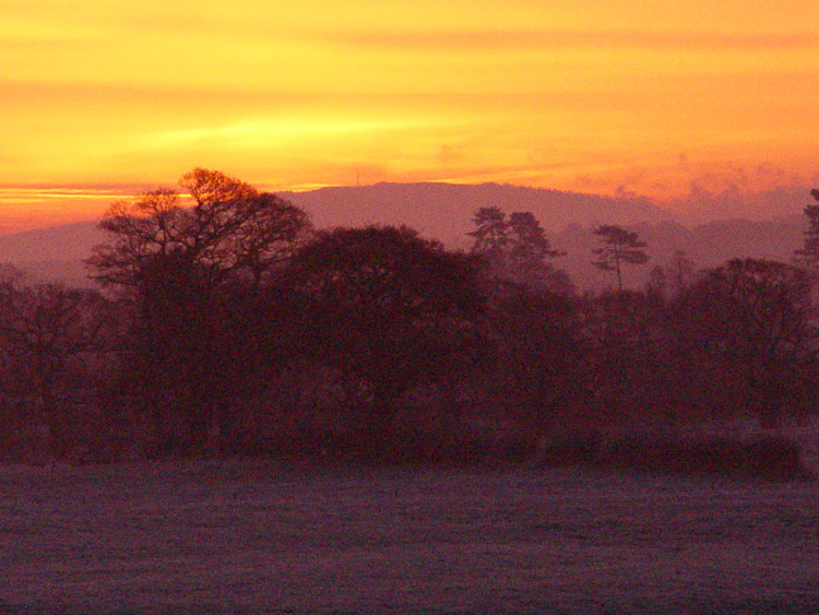
The Wrekin submitted by VirtHist : I took this photo from my back garden last winter. The Wrekin is about 18 miles away and in the midground you can just make out The Berth hillfort. The Wrekin was possibly the 'capitol' of the Cornovii tribes region and was taken by the Romans in 47 AD. Remants of this attack have been found at the site. (Vote or comment on this photo)

The Wrekin
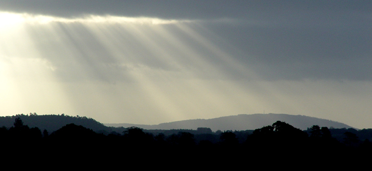
The Wrekin submitted by VirtHist : This photograph actually includes three Iron Age hillforts: Haughmond Hill (left), The Wrekin (middle) and The Berth (midground right). I'm a very lucky man that this is a view from my bathroom window! (6 comments - Vote or comment on this photo)

The Wrekin
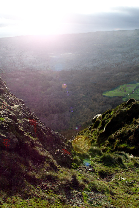
The Wrekin submitted by VirtHist : Another quick Photoshop reconstruction of 300BC, this time of that beautiful view to the southwest, We can't be certain as to how much woodland would have been cleared by now, but I've gone for 'not much' - even thought it was probably more than this. The symbols on the rocks are of the Celtic sun wheel and I've placed the blood stains of an animal sacrifice there too for good measure. (2 comments - Vote or comment on this photo)

The Wrekin
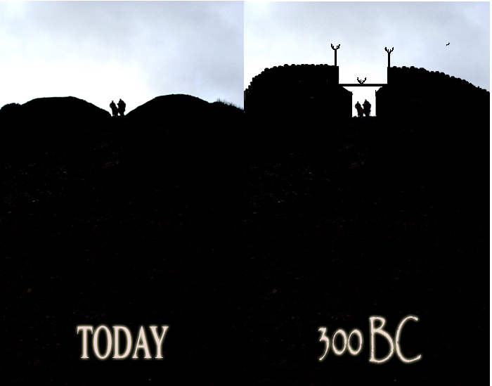
The Wrekin submitted by VirtHist : Thought I'd do a quick Photoshop reconstruction of what Heaven's Gate might have looked like when the Cornovii were passing through it. (1 comment - Vote or comment on this photo)

The Wrekin
The Wrekin submitted by VirtHist : Looking southwest just beyond the southwest entrance. The River Severn (Sabrina, Hafren) is in the mid-distance. (3 comments - Vote or comment on this photo)

The Wrekin
The Wrekin submitted by TimPrevett : Standing on the north side of The Wrekin, looking out; remarkable views from this hill - 1300 feet high at its tallest. A slight rampart is visible from the top left to the centre, and then changes angle going from centre to right. See main entry - click on the blue text to the left of the picture for more information.

The Wrekin
The Wrekin submitted by TimPrevett : Looking from the inside of the inner inturned rampart at The Wrekin. See main entry - click on the blue text to the left of the picture for more information.

The Wrekin
The Wrekin submitted by TimPrevett : Approaching Heaven's Gate, the inner entrance to The Wrekin. Notice the scale of the people against the entrance from this angle; 2000 years after being stormed by The Romans it is still impressive. See main entry - click on the blue text to the left of the picture for more information. (1 comment)

The Wrekin
The Wrekin submitted by VirtHist : Getting ever closer to the Wrekin. You can just make out the ramparts around the summit. (3 comments)

The Wrekin
The Wrekin submitted by TimPrevett : SJ630083 The Wrekin; atop this monster of a hill which dominates the landscape between Shrewsbury & Telford, are some remains of a hillfort. A spectacular location. We went up the Wrekin on Christmas Day one year - and got caught in a snowstorm at the top! This picture taken from Corbet Wood SJ525237, which gives commanding views across the hills to the south.

The Wrekin
The Wrekin submitted by w650marion : What's this circular mound with a ditch on the top of the Wrekin Hillfort, not far from the Bronze Age cairn? Unfortunately for me, it's not an ancient monument, but still interesting. It is the remains of one of four searchlights from WWll, placed there to protect Buildwas Power Station from enemy aircraft. The positions of the searchlights are indicated by four regularly placed circular ... (1 comment)

The Wrekin
The Wrekin submitted by postman : As seen zooming from Caer Caradoc

The Wrekin
The Wrekin submitted by TimPrevett : On entering through the outer inturned entrance, the ground levels for a while, and a plantation becomes visible to the right. If you enter this wood, some terraces become visible; in this picture we are standing on a terrace (compare the height to the left), with a much steeper drop down to another terrace. Mak, who contributes as VirtHist to The Portal and (among other things!) does the Virtua...

The Wrekin
The Wrekin submitted by TimPrevett : The outside of the inner ramparts, looking east; it is in this area that the earthworks remain at their most considerable. See main entry - click on the blue text to the left of the picture for more information.

The Wrekin
The Wrekin submitted by TimPrevett : Approaching the outer entrance to the hillfort - Hell's Gate on the north east side of The Wrekin. See main entry - click on the blue text to the left of the picture for more information.

The Wrekin
The Wrekin submitted by TimPrevett : The south west outer entrance and rampart at The Wrekin. See main entry for details - click on blue text to left of picture.

The Wrekin
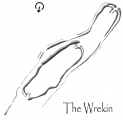
The Wrekin submitted by VirtHist : I thought I create my own plan to place here as an aid to anyone else visiting. The top is north and the arrow indicates where the close up photo was taken from.

Do not use the above information on other web sites or publications without permission of the contributor.
Click here to see more info for this site

Nearby sites

Click here to view sites on an interactive OS map

Key: Red: member's photo, Blue: 3rd party photo, Yellow: other image, Green: no photo - please go there and take one, Grey: site destroyed

Download sites to:
KML (Google Earth)
GPX (GPS waypoints)
CSV (Garmin/Navman)
CSV (Excel)

To unlock full downloads you need to sign up as a Contributory Member. Otherwise downloads are limited to 50 sites.


Turn off the page maps and other distractions

Nearby sites listing. In the following links * = Image available
 997m E 90° Willow Moor Barrow Cemetary* Barrow Cemetery (SJ640083)
 4.8km NNE 33° St Margarets Well (Telford) Holy Well or Sacred Spring (SJ656123)
 8.3km WSW 243° Cove Coppice* Barrow Cemetery (SJ555046)
 8.4km S 184° Holy Trinity (Much Wenlock)* Ancient Cross (SO623999)
 8.4km S 185° St Owens Well* Holy Well or Sacred Spring (SO622999)
 8.7km WSW 237° Stevenshill* Hillfort (SJ556036)
 9.2km NNE 17° Kynnersley Burnt Mounds Artificial Mound (SJ657171)
 9.4km E 82° Castle Farm* Hillfort (SJ724095)
 9.5km S 183° St Milburgas Well (Much Wenlock)* Holy Well or Sacred Spring (SO625988)
 9.6km NW 309° Upton Magna* Timber Circle (SJ555144)
 10.8km NNE 28° Wall Camp* Hillfort (SJ681178)
 10.8km WNW 300° Haughmond Hill Camp* Hillfort (SJ537138)
 11.6km NW 314° Ebury Hillfort* Hillfort (SJ546164)
 12.2km SW 232° The Frog Well Holy Well or Sacred Spring (SJ53340084)
 12.9km W 279° Shrewsbury Orthodox Church* Cursus (SJ5026310469)
 12.9km N 355° Ellerdine Heath* Standing Stone (Menhir) (SJ6191821168)
 14.0km W 271° The Burgs* Hillfort (SJ48950873)
 14.4km WNW 287° High Cross (Shrewsbury) Ancient Cross (SJ492126)
 14.8km WNW 286° Shrewsbury Museum and Art Gallery* Museum (SJ488126)
 14.9km ENE 57° Pave Lane Hillfort* Misc. Earthwork (SJ756164)
 14.9km SSE 164° Morville Cross* Ancient Cross (SO6695893875)
 15.6km SSW 205° Mogg Forest Hillfort* Hillfort (SO5621194262)
 15.9km SW 232° The Lawley (Northern)* Hillfort (SO50289863)
 17.3km SW 231° The Lawley (Summit)* Hillfort (SO49459745)
 17.9km SE 134° St Peter's Well (Worfield)* Holy Well or Sacred Spring (SO758958)
View more nearby sites and additional images

<< Kibitsuhiko Jinja shrine

Tilquhillie Standing Stone >>

Please add your thoughts on this site

Cave Of Forgotten Dreams on DVD

Cave Of Forgotten Dreams on DVD

Sponsors

Auto-Translation (Google)

Translate from English into:

"The Wrekin" | Login/Create an Account | 19 News and Comments
  
Go back to top of page    Comments are owned by the poster. We aren't responsible for their content.
Re: The Wrekin by luminessence on Saturday, 02 February 2013
(User Info | Send a Message)
Does anybody know what the Cornovii called the Wrekin Hill Fort, please?
[ Reply to This ]
    Re: The Wrekin by 4clydesdale7 on Monday, 04 February 2013
    (User Info | Send a Message)
    There is a school of thought that suggests 'Uriconio' which became 'Wrekin'
    [ Reply to This ]

Volunteers help preserve The Wrekin’s history by davidmorgan on Tuesday, 22 November 2011
(User Info | Send a Message)
Work to save 5,000 years of history on top of The Wrekin has been hailed a success by volunteers.

Restoration teams have spent the last few days working to protect the remains of a Bronze Age barrow and an Iron Age fort, 1,335ft above the Shropshire plain.

Pete Lambert, from Shropshire Wildlife Trust, said The Wrekin held a special place in the history of the area which needed to be preserved for future generations.

He said: “We have been working for three days to repair the effects of millions of feet tramping up to the summit.

“We have been repairing a Bronze Age barrow exposed by erosion which could have been built as a burial chamber 5,000 years ago.

“We are covering it with matting and then sowing it with grass seed to protect it from further damage.

“It was starting to become very exposed so we needed to seal in that bit of archaeology.”

The Wrekin was once home to the Celtic Cornovii tribe which built the fort and called it their capital. It sprawled the summit of the hill and covered about 20 acres.

Mr Lambert added: “Hell Gate, the earthwork entrance created by the Cornovii, has also suffered extensive erosion and is being restored.

“The Wrekin is also regaining a little height this week. The triangulation point had dropped about one-and-a-half feet over the last few years as its stone base had worn away. We have had more than 10 volunteers working very hard to build it up again, a fantastic landmark seen from hilltops around and beyond the county,” he said.

Read more: http://www.shropshirestar.com/news/2011/10/05/volunteers-help-preserve-the-wrekins-history/#ixzz1bmevetyN

Submitted by coldrum.
[ Reply to This ]

Is landmark an ancient calendar? by Andy B on Monday, 30 March 2009
(User Info | Send a Message)
Was Shropshire’s landmark hill once used as a mystical sundial by early man?

That is the theory of Wellington author and historian George Evans who believes that a V shaped formation of rocks on The Wrekin is a “calendar stone”.

And at midday on the equinox, the first day of spring, a coin sized disc of light is supposed to shine through the cleft of rocks.

Mr Evans believes the summit of The Wrekin was a sort of “cathedral” for early sun worshippers and that the “calendar stone” played an important part in the lives of its first human inhabitants.

The Shropshire Star put his theory to the at the spring equinox when reporter Peter Johnson and photographer Ian Sheppard climbed The Wrekin before descending a steep scree slope on the south side of the summit just below the rock known as the Cuckoo’s Cup or Raven’s Bowl.

There they met George Whittingham, of Madeley, who had also read about the calendar stone theory and wanted to photograph the equinox phenomenon.

By midday, the shaft of light had started to appear, growing in size and travelling across a flat patch of rock for the next 10 minutes. Mr Whittingham said: “I’m impressed. I definitely think there is something in George Evans’ theories.

More with photo: Shropshire Star.
[ Reply to This ]
    Re: Is landmark an ancient calendar? by Wendypeter on Tuesday, 22 September 2020
    (User Info | Send a Message)
    Would love to see this photo, but link no longer works.
    We climbed the hill today, Sept 21, but could not find the stones.
    [ Reply to This ]
      Re: Is landmark an ancient calendar? by davidmorgan on Tuesday, 22 September 2020
      (User Info | Send a Message)
      Link now fixed. That calendar theory doesn't sound very convincing to me.
      [ Reply to This ]

Future of hill under the spotlight by coldrum on Friday, 30 January 2009
(User Info | Send a Message)
Future of hill under the spotlight

The future of Shropshire’s landmark hill, including controversial plans for a huge opencast coal mine, will come under the spotlight at a public meeting.

People will also have the chance to debate whether a new visitor centre should be built at The Wrekin or whether it should be left as it is.

The open forum has been called by All Friends Round The Wrekin, a group of people who want to protect the hill for future generations. The meeting is at Wellington Civic Centre at 7pm on Wednesday.

Group chairman George Evans said: “There is a lot to discuss at the moment and we expect a big crowd.

“The lavatories at the main entrance have remained shut for many years - can we persuade, bully or shame Telford & Wrekin Council into reopening them?

“There is traffic congestion on busy weekends. Do we need more parking or fewer cars? Would shuttle buses from Wellington help?

“Do we want a visitor centre and if so, where - Forest Glen or Wellington? Should the Donkey Field be developed?

“Do we want opencast coal mining? Are we going to the public inquiry?”

Mr Evans said another issue was the huge archaeological and historic importance of the Iron Age hill fort at the summit of The Wrekin.

http://www.shropshirestar.com/2008/12/08/future-of-hill-under-the-spotlight/
[ Reply to This ]

Re: Roman Invasion by Arjessa on Tuesday, 24 June 2008
(User Info | Send a Message)
Ostorius Scapula had the Hill-fort stormed in AD47, not AD74. It was near the start of the Roman Invasion of Britain, as a show of strength. I believe the Cornovii surrendered very quickly!
[ Reply to This ]

Re: The Wrekin by Anonymous on Tuesday, 24 June 2008
Hey, I grew up in The Wrekin area and know it well.

Readers ought to know of the Devil legend regarding The Wrekin. The Devil, who had something against the inhabitants of nearby Shrewsbury, was on his way there from his headquarters at the Stipersones (there is a pile of rocks there called 'The Devil's Chair), with a spittleful (shovelful) of earth so he could dam the Severn and so flood & drown the city. It was a very hot day, and Old Nick happened to bump into a travelling cobbler who had come from Shrewsbury, carrying a sackful of shoes he was to repair, & being hot and weary he asked the cobbler how far it was to Shrewsbury. The cobbler spotted the Devil's hooves and tail poking out from under his cloak, and putting two and two together, he emptied his sack of shoes onto the ground and replied, "Oh, it's miles and miles and miles. In fact, I've wore out all these shoes on the way from there!" The cobbler went on his way. In despair the Devil gave up on his evil mission, and dumped his load of earth where he stood. This is, of course, the true origin of The Wrekin!

At Kidderminster, a few miles to the south in the woods to the west of the town, there is a strange earthen mound which has the same legend attached. This is called 'The Devil's Spittleful'! I believe it's in the grounds of the West Midlands Safari Park. I don't know if Old Nick would approve of baboons etc. clambering all over it.

The Wrekin really is a noticeable landmark, visible for 60+ miles around. We used to say, if we had been on a long journey, or had got lost, that we'd 'gone all round The Wrekin' to get there. I think it's actually a 'volcanic plug' and is dead in a NE - SW line with two other famous Shropshire 'plugs', The Lawley and the biggest of the three at 1,560 feet, Caer Caradoc, associated with the British rebel Caratacus. This is also one of the theoretical sites of a battle involving Ostorius Scapula; it too has an imperessive hill fort incorporating the crags that adorn its brow and flanks. It's a nice half day's walk to & from Church Stretton - check it out!

Phil Ryder
Folsom California.
[ Reply to This ]

The Wrekin Hillfort Event by Andy B on Monday, 23 June 2008
(User Info | Send a Message)

26th July 2008, The Wrekin Hillfort Event

26th July • The Wrekin Hillfort Event

Forest Glen Car Park

Story telling, Iron Age re-enactment and more

Contact 01743 284280

http://www.shropshirehillsaonb.co.uk/thingstodo/events.htm
[ Reply to This ]

Historical Wrekin Link by coldrum on Friday, 16 May 2008
(User Info | Send a Message)
http://www.wrekinfriends.com/newsItems/departments/historicalWrekin
[ Reply to This ]

Historian calls for dig of the Wrekin due to digital TV switchover work by Andy B on Friday, 08 February 2008
(User Info | Send a Message)
Wellington historian George Evans today called for a new archaeological dig to uncover the secrets of the hill fort at the top of The Wrekin.

He believes the investigation could take place while National Grid Wireless lays down a concrete track by Hell’s Gate.

Work is soon due to take place to upgrade the existing mast for the switchover to digital TV in 2011.

It will mean vehicles going up and down The Wrekin for six months - and the existing track is too eroded to cope.

National Grid Wireless is consulting landowners and interested parties before putting in a planning application.

Mr Evans, president of All Friends Round The Wrekin, said: “That fort has never been properly investigated.

“A dig was started in 1939 but had to be abandoned because of the war.

“I hope National Grid Wireless may be willing to make a contribution to the cost.”

http://www.shropshirestar.com/2008/02/wrekin-dig-call-by-historian/
[ Reply to This ]

Re: The Wrekin by Anonymous on Sunday, 01 January 2006
What A Most interesting site been browsing the info and picks for about an hour, found it most informative, the photos are excellent.
I do believe that at the foot of the Wrekin on the former site of the Forest glen there should be a small Craft , Wrekin, Cornovii history centre, to inform not just the Locals but the visitors who come from far and wide to climb our beautiful Wrekin.
Gwyn Hartley. (Caelwyn)
[ Reply to This ]
    Re: The Wrekin by Condros on Monday, 23 June 2008
    (User Info | Send a Message)
    Gwyn, I couldn't agree more, I wish more of the postings on these types of sites contained the information that this one has provided.
    Far too many times the site listing usually only contains basic information, this has been well photographed with great historical references, and a genuine concern for it's future.
    [ Reply to This ]

Re: The Wrekin by SapphireRose on Thursday, 17 March 2005
(User Info | Send a Message)
Thanks Tim, will probably be in touch!

Kind regards

Elaine
[ Reply to This ]

Re: The Wrekin by TimPrevett on Thursday, 17 March 2005
(User Info | Send a Message)
The Wrekin has fantastic views indeed; around midsummer I know a number of us will probably be at Mitchell's Fold circle. There's also a Shropshire Stones Meet on the Saturday and Sunday June 11th and 12th 2005 - see HERE for more. Cheers, Tim.
[ Reply to This ]

Re: The Wrekin by SapphireRose on Wednesday, 16 March 2005
(User Info | Send a Message)
Wonderful images! They are definitely inspiring me for my first walk up which I'm planning for around the summer solstice. The Wrekin is a major point of inspiration across a wider area than just Shropshire with the Black Country saying of 'round the Wrekin' as the long way round!

Elaine x
aka ShropshirePagan
[ Reply to This ]

Re: The Wrekin by VirtHist on Monday, 03 January 2005
(User Info | Send a Message)
... and a great New Years Day we had too, even if we nearly did get blown of the top! Thanks Tim.

Mak
[ Reply to This ]

Re: The Wrekin by TimPrevett on Friday, 31 December 2004
(User Info | Send a Message)
A gallery of Wrekin photos here:
http://www.bbc.co.uk/shropshire/features/halloween/wrekin_gallery_04.shtml

and more on folklore here:
http://www.bbc.co.uk/shropshire/features/halloween/wrekin_giant.shtml

Up there for a New Year's morning walk tomorrow!

Tim
[ Reply to This ]

Your Name: Anonymous [ Register Now ]
Subject:


Add your comment or contribution to this page. Spam or offensive posts are deleted immediately, don't even bother

<<< What is five plus one as a number? (Please type the answer to this question in the little box on the left)
You can also embed videos and other things. For Youtube please copy and paste the 'embed code'.
For Google Street View please include Street View in the text.
Create a web link like this: <a href="https://www.megalithic.co.uk">This is a link</a>  

Allowed HTML is:
<p> <b> <i> <a> <img> <em> <br> <strong> <blockquote> <tt> <li> <ol> <ul> <object> <param> <embed> <iframe>

We would like to know more about this location. Please feel free to add a brief description and any relevant information in your own language.
Wir möchten mehr über diese Stätte erfahren. Bitte zögern Sie nicht, eine kurze Beschreibung und relevante Informationen in Deutsch hinzuzufügen.
Nous aimerions en savoir encore un peu sur les lieux. S'il vous plaît n'hesitez pas à ajouter une courte description et tous les renseignements pertinents dans votre propre langue.
Quisieramos informarnos un poco más de las lugares. No dude en añadir una breve descripción y otros datos relevantes en su propio idioma.