<< Text Pages >> The Combe (Dorset) - Misc. Earthwork in England in Dorset
Submitted by TimPrevett on Monday, 09 January 2017 Page Views: 1365
Multi-periodSite Name: The Combe (Dorset)Country: England County: Dorset Type: Misc. Earthwork
Nearest Town: Cerne Abbas Nearest Village: Sydling St Nicholas
Map Ref: SY624997
Latitude: 50.795636N Longitude: 2.534857W
Condition:
| 5 | Perfect |
| 4 | Almost Perfect |
| 3 | Reasonable but with some damage |
| 2 | Ruined but still recognisable as an ancient site |
| 1 | Pretty much destroyed, possibly visible as crop marks |
| 0 | No data. |
| -1 | Completely destroyed |
| 5 | Superb |
| 4 | Good |
| 3 | Ordinary |
| 2 | Not Good |
| 1 | Awful |
| 0 | No data. |
| 5 | Can be driven to, probably with disabled access |
| 4 | Short walk on a footpath |
| 3 | Requiring a bit more of a walk |
| 2 | A long walk |
| 1 | In the middle of nowhere, a nightmare to find |
| 0 | No data. |
| 5 | co-ordinates taken by GPS or official recorded co-ordinates |
| 4 | co-ordinates scaled from a detailed map |
| 3 | co-ordinates scaled from a bad map |
| 2 | co-ordinates of the nearest village |
| 1 | co-ordinates of the nearest town |
| 0 | no data |
Internal Links:
External Links:
Misc. Earthwork in Dorset
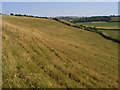
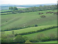
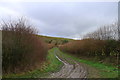
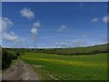
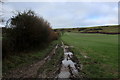
Remains of an Iron Age or Romano-British field system north of Dorchester, west of Cerne Abbas.
Best viewed from a distance. Pulling off the Dorchester - Yeovil road, there's a wide space for entrance to a field, with good views to the south east. No public access to the fields concerned, as far as I know.
You may be viewing yesterday's version of this page. To see the most up to date information please register for a free account.
 (PID:161202)")
Do not use the above information on other web sites or publications without permission of the contributor.
Nearby Images from Geograph Britain and Ireland:
©2008(licence)
©2010(licence)
©2019(licence)
©2015(licence)
©2019(licence)
The above images may not be of the site on this page, they are loaded from Geograph.
Please Submit an Image of this site or go out and take one for us!
Click here to see more info for this site
Nearby sites
Key: Red: member's photo, Blue: 3rd party photo, Yellow: other image, Green: no photo - please go there and take one, Grey: site destroyed
Download sites to:
KML (Google Earth)
GPX (GPS waypoints)
CSV (Garmin/Navman)
CSV (Excel)
To unlock full downloads you need to sign up as a Contributory Member. Otherwise downloads are limited to 50 sites.
Turn off the page maps and other distractions
Nearby sites listing. In the following links * = Image available
2.5km ENE 63° Up Cerne/Sydling St Nicholas Boundary Stone Marker Stone (ST64610078)
2.9km SSW 204° Hog Cliff Bottom Barrow Round Barrow(s) (SY61209711)
2.9km S 184° Hog Cliff Hill Barrow Round Barrow(s) (SY62179676)
3.0km W 277° The Castle Hillfort (ST594001)
3.2km S 180° Hog Cliff Hill Settlement Ancient Village or Settlement (SY624965)
3.2km E 80° Dickley Hill Bowl Barrows Round Barrow(s) (ST65600026)
3.2km W 267° Cattistock holy well Holy Well or Sacred Spring
3.3km E 80° Dickley Hill Settlement Ancient Village or Settlement (ST65650027)
3.3km E 95° Smacam Down Settlement Ancient Village or Settlement (SY657994)
3.3km NE 46° Wancombe Hill Field System Misc. Earthwork (ST64790200)
3.3km E 95° Smacam Down Long Barrow Long Barrow (SY6572599389)
3.4km E 94° Smacam Down Bowl Barrow Round Barrow(s) (SY65859946)
3.5km ENE 57° Weam Commen Hill Field System Misc. Earthwork (ST654016)
3.8km SE 127° Furzey Down Road Ancient Trackway (SY654974)
3.8km NE 45° Seldon Hill Settlement Ancient Village or Settlement (ST65100235)
3.8km ESE 116° Nether Cerne Field System Misc. Earthwork (SY658980)
3.9km SE 124° Crete Hill Bowl Barrow Round Barrow(s) (SY656975)
4.0km SE 137° Crete Hill Field System Misc. Earthwork (SY651968)
4.1km SSE 148° Jackman's Cross Bowl Barrow Round Barrow(s) (SY64559623)
4.2km N 11° Cross and Hand Stone* Standing Stone (Menhir) (ST632038)
4.4km SE 145° Lawyer's Plantation Cross Dyke Misc. Earthwork (SY64949606)
4.4km SE 145° Jackman's Plantation Bowl Barrow Round Barrow(s) (SY64929604)
4.4km SE 142° Coronation Plantation Bowl Barrow Round Barrow(s) (SY65159620)
4.5km ENE 68° St Augustine's Well (Cerne Abbas)* Holy Well or Sacred Spring (ST6664001369)
4.6km SSE 151° Grimstone Down Settlements Ancient Village or Settlement (SY646957)
View more nearby sites and additional images


 We would like to know more about this location. Please feel free to add a brief description and any relevant information in your own language.
 Wir möchten mehr über diese Stätte erfahren. Bitte zögern Sie nicht, eine kurze Beschreibung und relevante Informationen in Deutsch hinzuzufügen.
 Nous aimerions en savoir encore un peu sur les lieux. S'il vous plaît n'hesitez pas à ajouter une courte description et tous les renseignements pertinents dans votre propre langue.
 Quisieramos informarnos un poco más de las lugares. No dude en añadir una breve descripción y otros datos relevantes en su propio idioma.