


<< Our Photo Pages >> Cross Shaped Stone of Keverigg - Ancient Cross in England in Cumbria
Submitted by MonumentMan on Monday, 14 October 2019 Page Views: 3162
Early MedievalSite Name: Cross Shaped Stone of KeveriggCountry: England County: Cumbria Type: Ancient Cross
Nearest Town: Shap
Map Ref: NY5751916849
Latitude: 54.545104N Longitude: 2.658182W
Condition:
| 5 | Perfect |
| 4 | Almost Perfect |
| 3 | Reasonable but with some damage |
| 2 | Ruined but still recognisable as an ancient site |
| 1 | Pretty much destroyed, possibly visible as crop marks |
| 0 | No data. |
| -1 | Completely destroyed |
| 5 | Superb |
| 4 | Good |
| 3 | Ordinary |
| 2 | Not Good |
| 1 | Awful |
| 0 | No data. |
| 5 | Can be driven to, probably with disabled access |
| 4 | Short walk on a footpath |
| 3 | Requiring a bit more of a walk |
| 2 | A long walk |
| 1 | In the middle of nowhere, a nightmare to find |
| 0 | No data. |
| 5 | co-ordinates taken by GPS or official recorded co-ordinates |
| 4 | co-ordinates scaled from a detailed map |
| 3 | co-ordinates scaled from a bad map |
| 2 | co-ordinates of the nearest village |
| 1 | co-ordinates of the nearest town |
| 0 | no data |
Internal Links:
External Links:
I have visited· I would like to visit
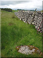
Anne T visited on 9th Jul 2022 - their rating: Cond: 3 Amb: 3 Access: 3 Cross Shaped Stone of Keverigg: We went looking for the boundary stone inscribed with a cross, as marked on the modern OS map, but were unable to find it (grass too high and lots of lichen and moss on surrounding rocks to be able to make out the carved cross).
My impression of this particular stone is that it's the remnants of a quarried stone (or natural), as it lies on/near a long line of limestone pavement.
")
On investigation of the site attributed to the 'Cross Stone of Keverigg' not only was the carved 19thC boundary stone present, but additionally a 'cross-shaped' boulder of Shap Blue granite lay just 3m to the south.
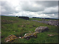
This recumbent 'cross shaped' stone (1.0mx1.0mx0.3m) appears hand-worked to resemble a cross or boundary stone which may predate the 19thC carved small boulder nearby. The 'cross shaped' stone is surrounded by a small arc of at least 9 boulders of Shap Pink granite to the south by Trainrigg Sike Beck.
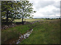
For more photographs and information see Geograph Photo 2459658 Cross Stone of Keverigg, which shows "the (cross stone) is possibly the smallest of a group of granite boulders lying by the rivulet of Trainrigg Sike. It is the closest to the dry stone wall though and is the meeting point for three parishes: Shap, Crosby Ravensworth and Sleagill". Geograph Photo 2349663 Boulders by Trainrigg Sike also shows the environs of the cross stone near Trainrigg Sike.
Little registered information exists on the age or existence of this stone other than this evidence and its record on the 1858/59 parish map: National Library of Scotland OS Map 1863 for Crosby Ravensworth; Newby; Shap Rural; Sleagill.
The cross shape of the nearby stone I found is crude - but it cannot be a coincidence that the cross stone and boundary stone are close together. I interpret it as an earlier boundary cross or meetings stone, especially with it being at the meeting point of three parishes.
Note: If anyone knows anything else about this stone or this site, we'd be pleased to hear from you. Please post a comment below. Thank you.
You may be viewing yesterday's version of this page. To see the most up to date information please register for a free account.
")
")
")
")
Do not use the above information on other web sites or publications without permission of the contributor.
Nearby Images from Geograph Britain and Ireland:
©2011(licence)
©2011(licence)
©2011(licence)

©2014(licence)
©2008(licence)
The above images may not be of the site on this page, they are loaded from Geograph.
Please Submit an Image of this site or go out and take one for us!
Click here to see more info for this site
Nearby sites
Key: Red: member's photo, Blue: 3rd party photo, Yellow: other image, Green: no photo - please go there and take one, Grey: site destroyed
Download sites to:
KML (Google Earth)
GPX (GPS waypoints)
CSV (Garmin/Navman)
CSV (Excel)
To unlock full downloads you need to sign up as a Contributory Member. Otherwise downloads are limited to 50 sites.
Turn off the page maps and other distractions
Nearby sites listing. In the following links * = Image available
23m NNW 336° Cross Stone of Keverigg Ancient Cross (NY57511687)
1.1km NW 322° Gunnerkeld* Stone Circle (NY56821775)
1.4km SSE 152° Thunder Stone (Castlehowe Scar)* Natural Stone / Erratic / Other Natural Feature (NY5817615610)
1.7km SSE 148° Castlehow Stones Stone Row / Alignment (NY584154)
1.8km SE 138° Castlehowe Scar Stone Circle* Stone Circle (NY5874815472)
1.9km SE 139° Castlehowe Scar Stone Row* Stone Row / Alignment (NY5873615412)
2.3km SW 233° Skellaw Hill Tumulus* Round Barrow(s) (NY5565015470)
2.3km SW 225° Aspers Field* Standing Stone (Menhir) (NY5584115208)
2.4km SW 222° Goggleby Stone* Standing Stone (Menhir) (NY5592215093)
2.4km SSW 210° The Giant's Foot (Cumbria)* Standing Stone (Menhir) (NY5630014781)
2.5km SW 231° Keld Lane Stones* Standing Stone (Menhir) (NY5554615286)
2.6km WSW 245° Thunder Stone (Shap)* Natural Stone / Erratic / Other Natural Feature (NY55151575)
2.9km SE 133° Iron Hill North* Stone Circle (NY59631482)
2.9km WNW 297° Wilson Scar Stone Circle (NY549182)
3.0km SE 134° Iron Hill South* Stone Circle (NY59641476)
3.0km NW 311° Shapbeck Plantation* Stone Circle (NY55261886)
3.2km SSW 194° Shap Avenue* Multiple Stone Rows / Avenue (NY567138)
3.5km SSE 154° Hardendale Timber Circle (NY590137)
3.6km WSW 237° Stone Howe Cairn (NY545149)
3.6km S 191° Kemp Howe* Stone Circle (NY56801330)
3.6km W 276° Benny Howe Round Barrow(s) (NY53901729)
3.8km WNW 301° Out Scar Ancient Village or Settlement (NY543188)
3.9km SSE 153° Kalmott cairn circle* Ring Cairn (NY59301333)
4.0km SSE 155° Oddendale stone alignment* Stone Row / Alignment (NY5919113205)
4.2km S 169° St Anne's Well (Shap)* Holy Well or Sacred Spring (NY5829412700)
View more nearby sites and additional images


 We would like to know more about this location. Please feel free to add a brief description and any relevant information in your own language.
 Wir möchten mehr über diese Stätte erfahren. Bitte zögern Sie nicht, eine kurze Beschreibung und relevante Informationen in Deutsch hinzuzufügen.
 Nous aimerions en savoir encore un peu sur les lieux. S'il vous plaît n'hesitez pas à ajouter une courte description et tous les renseignements pertinents dans votre propre langue.
 Quisieramos informarnos un poco más de las lugares. No dude en añadir una breve descripción y otros datos relevantes en su propio idioma.