<< Our Photo Pages >> The Galloway Stone - Natural Stone / Erratic / Other Natural Feature in England in Cumbria
Submitted by Anne T on Monday, 03 April 2017 Page Views: 4468
Natural PlacesSite Name: The Galloway StoneCountry: England County: Cumbria Type: Natural Stone / Erratic / Other Natural Feature
Nearest Town: Shap Nearest Village: Orton
Map Ref: NY58780994
Latitude: 54.483122N Longitude: 2.637722W
Condition:
| 5 | Perfect |
| 4 | Almost Perfect |
| 3 | Reasonable but with some damage |
| 2 | Ruined but still recognisable as an ancient site |
| 1 | Pretty much destroyed, possibly visible as crop marks |
| 0 | No data. |
| -1 | Completely destroyed |
| 5 | Superb |
| 4 | Good |
| 3 | Ordinary |
| 2 | Not Good |
| 1 | Awful |
| 0 | No data. |
| 5 | Can be driven to, probably with disabled access |
| 4 | Short walk on a footpath |
| 3 | Requiring a bit more of a walk |
| 2 | A long walk |
| 1 | In the middle of nowhere, a nightmare to find |
| 0 | No data. |
| 5 | co-ordinates taken by GPS or official recorded co-ordinates |
| 4 | co-ordinates scaled from a detailed map |
| 3 | co-ordinates scaled from a bad map |
| 2 | co-ordinates of the nearest village |
| 1 | co-ordinates of the nearest town |
| 0 | no data |
Internal Links:
External Links:
I have visited· I would like to visit
Modern-neolithic would like to visit
markj99 visited on 5th Sep 2020 - their rating: Cond: 5 Amb: 4 Access: 5 It nice to find a site that you don't have to walk 3 miles over moorland to visit.
The Galloway Stone is just such a site. Simply leave the M6 at Shap, turn L for Orton, then take the R turn to Salterwath just before the M6 underpass.
The Galloway Stone lies c. 50 yards to the L after 150 yards along this lane.
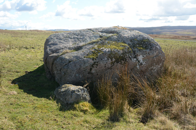
It looks like a large chunk of Shap Pink Granite so it can't be an erratic from Galloway.
The explanation for it's name may be that it was a marker on the Old Scotch Drove Road for turning onto the Galwaithegate or Galloway Road.
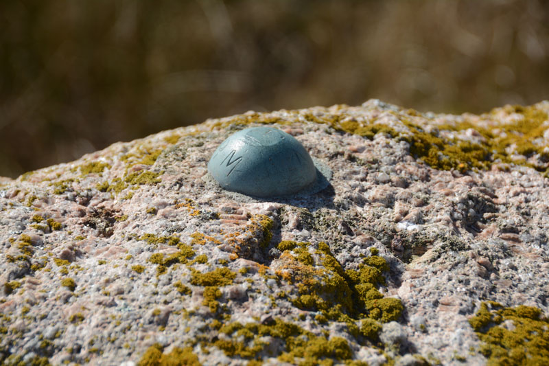
As an additional point of interest there is an Ordnance Survey Bench Mark Bolt on The Galloway Stone denoting a height of 98.8m.
Anne T visited on 2nd Apr 2017 - their rating: Cond: 3 Amb: 2 Access: 5 The Galloway Stone, near Orton, Cumbria: Spotted this named stone on the map as we drove towards Orton to find refreshments. There were many other large (but not quite as large as this) stones in the vicinity. With the M6 Northbound carriageway almost immediately behind, and above, this stone, I could have been forgiven for thinking this was left over from building the motorway.
In close up, the stone is clearly pink Shap granite, and had a red tint in the sunlight. A big surprise was find the bench mark with its large rivet on top of the stone.
Average ratings for this site from all visit loggers: Condition: 4 Ambience: 3 Access: 5

Sitting just to the west of the M6 Northbound carriageway, just off the B6261 to the village of Orton, on a spur of the road leading down to Salterwath, this large chunk of pink Shap granite is imposing, even though it sits within a landscape of other large stones. At first sight, it looks as if it is left over from the building of the motorway!
It's name indicates that it came from Galloway during the ice age, although Shap, with its pink granite is located only 5km to the north.
There is a bench mark right on top of the stone, with an unusually large rivet, which took us by surprise.
You may be viewing yesterday's version of this page. To see the most up to date information please register for a free account.


Do not use the above information on other web sites or publications without permission of the contributor.
Nearby Images from Geograph Britain and Ireland:

©2011(licence)

©2011(licence)

©2023(licence)

©2008(licence)

©2005(licence)
The above images may not be of the site on this page, they are loaded from Geograph.
Please Submit an Image of this site or go out and take one for us!
Click here to see more info for this site
Nearby sites
Key: Red: member's photo, Blue: 3rd party photo, Yellow: other image, Green: no photo - please go there and take one, Grey: site destroyed
Download sites to:
KML (Google Earth)
GPX (GPS waypoints)
CSV (Garmin/Navman)
CSV (Excel)
To unlock full downloads you need to sign up as a Contributory Member. Otherwise downloads are limited to 50 sites.
Turn off the page maps and other distractions
Nearby sites listing. In the following links * = Image available
1.1km NNE 31° Long Scar Pike* Cairn (NY5933810862)
1.2km WSW 252° Shap Wells Iron Age/Romano British Settlement Ancient Village or Settlement (NY5767309593)
2.4km NE 42° Wicker Street* Cairn (NY60411173)
2.5km ENE 67° Hazel Moor Enclosure* Ancient Village or Settlement (NY611109)
2.5km NE 49° White Hag* Stone Circle (NY60721160)
2.6km ENE 70° Kings Well spring* Holy Well or Sacred Spring (NY612108)
2.8km NE 53° White Hag Round cairn* Round Cairn (NY61011158)
2.8km N 350° St Anne's Well (Shap)* Holy Well or Sacred Spring (NY5829412700)
2.9km NNE 15° Seal Howe* Cairn (NY59541272)
3.0km NNE 16° Seal Howe Iron Age/Romano British field system* Misc. Earthwork (NY5961612783)
3.0km NNE 17° Seal Howe Cairn 2* Round Cairn (NY5969912781)
3.0km N 8° Oddendale* Stone Circle (NY59201291)
3.3km N 7° Oddendale stone alignment* Stone Row / Alignment (NY5919113205)
3.3km NNE 26° Seal Howe Cairn 3* Round Cairn (NY6025312925)
3.4km N 8° Kalmott cairn circle* Ring Cairn (NY59301333)
3.4km NE 53° Cow Green Long Barrow* Long Barrow (NY61541199)
3.6km WNW 294° Thorny Bank* Cairn (NY555114)
3.7km NE 39° Ewe Locks* Ancient Village or Settlement (NY6112512794)
3.8km E 81° Howe Robin Ancient Village or Settlement (NY625105)
3.8km N 3° Hardendale Timber Circle (NY590137)
3.9km NNW 329° Kemp Howe* Stone Circle (NY56801330)
3.9km SW 217° Clovenstone Hill* Natural Stone / Erratic / Other Natural Feature (NY5637706859)
4.1km WSW 256° To Stone or to'ther* Natural Stone / Erratic / Other Natural Feature (NY5479208955)
4.1km E 83° Penhurrock* Multiple Stone Rows / Avenue (NY62881043)
4.1km NE 55° Burwens Ancient Village or Settlement (NY622123)
View more nearby sites and additional images


 We would like to know more about this location. Please feel free to add a brief description and any relevant information in your own language.
 Wir möchten mehr über diese Stätte erfahren. Bitte zögern Sie nicht, eine kurze Beschreibung und relevante Informationen in Deutsch hinzuzufügen.
 Nous aimerions en savoir encore un peu sur les lieux. S'il vous plaît n'hesitez pas à ajouter une courte description et tous les renseignements pertinents dans votre propre langue.
 Quisieramos informarnos un poco más de las lugares. No dude en añadir una breve descripción y otros datos relevantes en su propio idioma.