<< Our Photo Pages >> Cherry Hill - Hillfort in England in Herefordshire
Submitted by byll on Sunday, 22 August 2010 Page Views: 8326
Iron Age and Later PrehistorySite Name: Cherry HillCountry: England County: Herefordshire Type: Hillfort
Nearest Town: Hereford Nearest Village: Fownhope
Map Ref: SO577352
Latitude: 52.013605N Longitude: 2.617747W
Condition:
| 5 | Perfect |
| 4 | Almost Perfect |
| 3 | Reasonable but with some damage |
| 2 | Ruined but still recognisable as an ancient site |
| 1 | Pretty much destroyed, possibly visible as crop marks |
| 0 | No data. |
| -1 | Completely destroyed |
| 5 | Superb |
| 4 | Good |
| 3 | Ordinary |
| 2 | Not Good |
| 1 | Awful |
| 0 | No data. |
| 5 | Can be driven to, probably with disabled access |
| 4 | Short walk on a footpath |
| 3 | Requiring a bit more of a walk |
| 2 | A long walk |
| 1 | In the middle of nowhere, a nightmare to find |
| 0 | No data. |
| 5 | co-ordinates taken by GPS or official recorded co-ordinates |
| 4 | co-ordinates scaled from a detailed map |
| 3 | co-ordinates scaled from a bad map |
| 2 | co-ordinates of the nearest village |
| 1 | co-ordinates of the nearest town |
| 0 | no data |
Internal Links:
External Links:
")
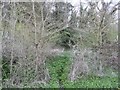
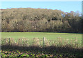
Steep and slippery hillside above Fownhope, slightly easier to access from Nupend Wood (nature trail heading Northeast leads to footpath into Fownhope park wood after which one can double back south to the ancient site). Quite a bit more distance that way but a good bit more secure under foot. A significant amount of old Yew trees can be seen along the top rampart, the inside of the fort is youngish open deciduous woodland. I felt that there was a rather uneasy atmosphere, but I might just have been imagining it.
The Iron Age fort of Cherry Hill is unique in the region in that it shows compelling evidence for the original fort having been destroyed in a violent and systematic manner. A new fort was later constructed on the site giving archaeologists a rare insight into an episode of instability and warfare in a time which was largely thought to be, in the main, peaceful.
You may be viewing yesterday's version of this page. To see the most up to date information please register for a free account.
")
")
")
")
Do not use the above information on other web sites or publications without permission of the contributor.
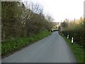
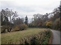
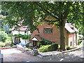
Nearby Images from Geograph Britain and Ireland:
©2016(licence)
©2016(licence)
©2021(licence)
©2022(licence)
©2008(licence)
The above images may not be of the site on this page, they are loaded from Geograph.
Please Submit an Image of this site or go out and take one for us!
Click here to see more info for this site
Nearby sites
Key: Red: member's photo, Blue: 3rd party photo, Yellow: other image, Green: no photo - please go there and take one, Grey: site destroyed
Download sites to:
KML (Google Earth)
GPX (GPS waypoints)
CSV (Garmin/Navman)
CSV (Excel)
To unlock full downloads you need to sign up as a Contributory Member. Otherwise downloads are limited to 50 sites.
Turn off the page maps and other distractions
Nearby sites listing. In the following links * = Image available
2.8km SE 145° Capler Camp* Hillfort (SO593329)
3.8km NNE 15° Backbury* Hillfort (SO587389)
5.4km WNW 282° Dinedor Camp* Hillfort (SO524364)
5.7km W 268° Holy Well (Dinedor)* Holy Well or Sacred Spring (SO52013501)
5.9km WNW 286° Rotherwas Ribbon* Ancient Trackway (SO52053690)
6.0km NNE 26° St Edith's Well (Herefordshire)* Holy Well or Sacred Spring (SO604406)
6.1km ESE 115° Oldbury Camp (Herefordshire)* Hillfort (SO632326)
6.8km WSW 254° St Ann's Well (Aconbury)* Holy Well or Sacred Spring (SO51173338)
7.3km SSE 152° Holy Well (Hole in the wall)* Holy Well or Sacred Spring (SO6109028682)
7.5km WSW 239° Higgin's Well* Holy Well or Sacred Spring (SO51163141)
7.6km WSW 253° Aconbury Hill* Hillfort (SO504331)
7.9km NW 304° St Ethelbert's Well (Hereford)* Holy Well or Sacred Spring (SO5112239684)
8.2km WNW 303° The King's Ditch Natural Stone / Erratic / Other Natural Feature (SO50873974)
8.2km NW 304° Hereford Museum and Art Gallery* Museum (SO5090039851)
8.8km S 191° Picts Cross Stone (Sellack) Standing Stone (Menhir) (SO560266)
10.0km NNW 331° The Wergin's Stone* Standing Stone (Menhir) (SO5297543981)
11.6km ENE 76° Redhill Wood Hillfort* Hillfort (SO690380)
11.9km ENE 75° Wall Hills Camp* Hillfort (SO692382)
12.3km NNW 335° Sutton Walls* Hillfort (SO525464)
12.9km WNW 288° Eaton Camp* Promontory Fort / Cliff Castle (SO454393)
13.1km SSE 169° Chase Wood Camp* Promontory Fort / Cliff Castle (SO602223)
13.5km NNW 331° St Ethelbert's Well (Marden)* Holy Well or Sacred Spring (SO512471)
13.7km SW 216° St Weonard's Burial Mound Artificial Mound (SO495242)
14.0km WSW 250° Kilpeck church* Early Christian Sculptured Stone (SO44513051)
14.0km WNW 300° Holy Well (Garway)* Holy Well or Sacred Spring (SO45554224)
View more nearby sites and additional images


 We would like to know more about this location. Please feel free to add a brief description and any relevant information in your own language.
 Wir möchten mehr über diese Stätte erfahren. Bitte zögern Sie nicht, eine kurze Beschreibung und relevante Informationen in Deutsch hinzuzufügen.
 Nous aimerions en savoir encore un peu sur les lieux. S'il vous plaît n'hesitez pas à ajouter une courte description et tous les renseignements pertinents dans votre propre langue.
 Quisieramos informarnos un poco más de las lugares. No dude en añadir una breve descripción y otros datos relevantes en su propio idioma.