

<< Our Photo Pages >> Aspers Field - Standing Stone (Menhir) in England in Cumbria
Submitted by baz on Tuesday, 30 December 2003 Page Views: 9358
Neolithic and Bronze AgeSite Name: Aspers FieldCountry: England County: Cumbria Type: Standing Stone (Menhir)
Nearest Town: Shap
Map Ref: NY5584115208 Landranger Map Number: 90
Latitude: 54.530214N Longitude: 2.683872W
Condition:
| 5 | Perfect |
| 4 | Almost Perfect |
| 3 | Reasonable but with some damage |
| 2 | Ruined but still recognisable as an ancient site |
| 1 | Pretty much destroyed, possibly visible as crop marks |
| 0 | No data. |
| -1 | Completely destroyed |
| 5 | Superb |
| 4 | Good |
| 3 | Ordinary |
| 2 | Not Good |
| 1 | Awful |
| 0 | No data. |
| 5 | Can be driven to, probably with disabled access |
| 4 | Short walk on a footpath |
| 3 | Requiring a bit more of a walk |
| 2 | A long walk |
| 1 | In the middle of nowhere, a nightmare to find |
| 0 | No data. |
| 5 | co-ordinates taken by GPS or official recorded co-ordinates |
| 4 | co-ordinates scaled from a detailed map |
| 3 | co-ordinates scaled from a bad map |
| 2 | co-ordinates of the nearest village |
| 1 | co-ordinates of the nearest town |
| 0 | no data |
Internal Links:
External Links:
I have visited· I would like to visit
TheCaptain visited on 19th Sep 2022 - their rating: Cond: 3 Amb: 3 Access: 4 In the field between the lane and the Goggleby Stone can be seen a large leaning stone nearby the wall. Can get a good view of this stone from both sides
SandyG visited on 8th Sep 2017 - their rating: Cond: 3 Amb: 4 Access: 4
trystan_hughes saw from a distance on 15th Apr 2016 - their rating: Cond: 3 Amb: 4 Access: 4
Anne T visited on 28th Jun 2014 - their rating: Cond: 4 Amb: 4 Access: 3 This stone is within sight of the Googleby Stone, although a little more difficult to access. The gate to access the field is in Keld Lane, but it's difficult to park here, and we were wary about walking in private fields. There were some dog walkers from the nearby caravan park walking in the fields, so we took advantage of a tumbled stone wall to get a photograph of the cup and ring mark.
Having come home and found out the extent of the stone row at Shap, we'll be going back to see more.
markj99 visited on 28th Dec 2013 - their rating: Cond: 3 Amb: 4 Access: 3 I have mixed feelings about the Shap stones. I am grateful for the stones that have been preserved but I regret that Shap Avenue has been effectively dismantled. I would love to have seen the avenue as it was meant to have been seen.
MAIGO NickyD have visited here
Average ratings for this site from all visit loggers: Condition: 3.2 Ambience: 3.8 Access: 3.6
")
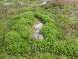
This stone (at NY558152) lies in the next field to the more well known Goggleby Stone (NY559151), from which I took this picture (with zoom). Both of these stones form a part of the Shap Stone Avenue.
Update November 2019: For more information, this stone is also featured as part of the Stone Rows of Great Britain's entry for Shap Avenue, which includes a description of the Shap alignment, photographs, access information and a plan of the row.
You may be viewing yesterday's version of this page. To see the most up to date information please register for a free account.
")
")
")
")
")
")
")
")
")
")
")
")
")
")
Do not use the above information on other web sites or publications without permission of the contributor.
Click here to see more info for this site
Nearby sites
Key: Red: member's photo, Blue: 3rd party photo, Yellow: other image, Green: no photo - please go there and take one, Grey: site destroyed
Download sites to:
KML (Google Earth)
GPX (GPS waypoints)
CSV (Garmin/Navman)
CSV (Excel)
To unlock full downloads you need to sign up as a Contributory Member. Otherwise downloads are limited to 50 sites.
Turn off the page maps and other distractions
Nearby sites listing. In the following links * = Image available
140m SE 144° Goggleby Stone* Standing Stone (Menhir) (NY5592215093)
304m WNW 284° Keld Lane Stones* Standing Stone (Menhir) (NY5554615286)
324m NW 323° Skellaw Hill Tumulus* Round Barrow(s) (NY5565015470)
626m SE 132° The Giant's Foot (Cumbria)* Standing Stone (Menhir) (NY5630014781)
876m NW 308° Thunder Stone (Shap)* Natural Stone / Erratic / Other Natural Feature (NY55151575)
1.4km WSW 256° Stone Howe Cairn (NY545149)
1.6km SSE 148° Shap Avenue* Multiple Stone Rows / Avenue (NY567138)
2.1km SSE 153° Kemp Howe* Stone Circle (NY56801330)
2.3km NE 45° Cross Shaped Stone of Keverigg* Ancient Cross (NY5751916849)
2.4km NE 44° Cross Stone of Keverigg Ancient Cross (NY57511687)
2.4km E 80° Thunder Stone (Castlehowe Scar)* Natural Stone / Erratic / Other Natural Feature (NY5817615610)
2.6km E 85° Castlehow Stones Stone Row / Alignment (NY584154)
2.7km WSW 238° Blaze Hill Round Cairn* Round Cairn (NY5355613795)
2.7km NNE 20° Gunnerkeld* Stone Circle (NY56821775)
2.8km NW 317° Benny Howe Round Barrow(s) (NY53901729)
2.9km E 85° Castlehowe Scar Stone Row* Stone Row / Alignment (NY5873615412)
2.9km E 84° Castlehowe Scar Stone Circle* Stone Circle (NY5874815472)
3.0km SW 232° White Raise Round Cairn A* Round Cairn (NY5347313431)
3.0km SW 233° White Raise Round Cairn B* Round Cairn (NY5342913450)
3.1km NNW 342° Wilson Scar Stone Circle (NY549182)
3.5km ESE 115° Hardendale Timber Circle (NY590137)
3.5km SE 135° St Anne's Well (Shap)* Holy Well or Sacred Spring (NY5829412700)
3.7km N 350° Shapbeck Plantation* Stone Circle (NY55261886)
3.8km E 95° Iron Hill North* Stone Circle (NY59631482)
3.8km E 96° Iron Hill South* Stone Circle (NY59641476)
View more nearby sites and additional images


 We would like to know more about this location. Please feel free to add a brief description and any relevant information in your own language.
 Wir möchten mehr über diese Stätte erfahren. Bitte zögern Sie nicht, eine kurze Beschreibung und relevante Informationen in Deutsch hinzuzufügen.
 Nous aimerions en savoir encore un peu sur les lieux. S'il vous plaît n'hesitez pas à ajouter une courte description et tous les renseignements pertinents dans votre propre langue.
 Quisieramos informarnos un poco más de las lugares. No dude en añadir una breve descripción y otros datos relevantes en su propio idioma.