


<< Our Photo Pages >> The Brough - Ancient Village or Settlement in Scotland in Orkney
Submitted by howar on Sunday, 14 November 2004 Page Views: 4586
Multi-periodSite Name: The Brough Alternative Name: Covenanters GravesCountry: Scotland County: Orkney Type: Ancient Village or Settlement
Nearest Town: Kirkwall
Map Ref: HY545101
Latitude: 58.975627N Longitude: 2.793125W
Condition:
| 5 | Perfect |
| 4 | Almost Perfect |
| 3 | Reasonable but with some damage |
| 2 | Ruined but still recognisable as an ancient site |
| 1 | Pretty much destroyed, possibly visible as crop marks |
| 0 | No data. |
| -1 | Completely destroyed |
| 5 | Superb |
| 4 | Good |
| 3 | Ordinary |
| 2 | Not Good |
| 1 | Awful |
| 0 | No data. |
| 5 | Can be driven to, probably with disabled access |
| 4 | Short walk on a footpath |
| 3 | Requiring a bit more of a walk |
| 2 | A long walk |
| 1 | In the middle of nowhere, a nightmare to find |
| 0 | No data. |
| 5 | co-ordinates taken by GPS or official recorded co-ordinates |
| 4 | co-ordinates scaled from a detailed map |
| 3 | co-ordinates scaled from a bad map |
| 2 | co-ordinates of the nearest village |
| 1 | co-ordinates of the nearest town |
| 0 | no data |
Internal Links:
External Links:
")
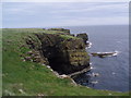
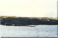
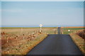
RCAHMS NMRS no.s HY51SW 4 The Brough and HY51SW 3 'Covenanters Graves', at HY54501005 and HY54501005 respectively, are best thought of as a promontory fort and outbuildings (I am reminded of the 'sailors graves' at the Brough of Bigging, but those by contrast lie within the fort, the adjoining land not so suitable there). The deep dip where the promontory is is a truly treacherous place to tread nowadays. Surely if you are building stuff for people you don't put it opposite a water-holding cup of land. This seems a little strange to me - was it excavated by people themselves for some now obscure reason.
CANMORE lists many features but in practice all is covered by tussocks of maritime grass - when I went all that could be safely observed were one slab on the promontory and another on the landward side, of which the latter can just be made out on my photo. A 12.5m circle to the east of the 'graves' is formed by two low earth and stone banks and may represent a greatly eroded building. Further along the northern edge of the path over the narrow strip of land several structures in a line have been found ; two ?hut-circles 3m across, a rectangular ?building 8m long, several hummocks with erect slabs.
You may be viewing yesterday's version of this page. To see the most up to date information please register for a free account.
")
Do not use the above information on other web sites or publications without permission of the contributor.
Nearby Images from Geograph Britain and Ireland:
©2006(licence)
©2008(licence)
©2018(licence)
©2009(licence)
©2009(licence)
The above images may not be of the site on this page, they are loaded from Geograph.
Please Submit an Image of this site or go out and take one for us!
Click here to see more info for this site
Nearby sites
Key: Red: member's photo, Blue: 3rd party photo, Yellow: other image, Green: no photo - please go there and take one, Grey: site destroyed
Download sites to:
KML (Google Earth)
GPX (GPS waypoints)
CSV (Garmin/Navman)
CSV (Excel)
To unlock full downloads you need to sign up as a Contributory Member. Otherwise downloads are limited to 50 sites.
Turn off the page maps and other distractions
Nearby sites listing. In the following links * = Image available
126m NNW 341° Castle of Hangie Bay* Stone Fort or Dun (HY54461022)
1.6km SW 233° Taing of Beeman* Ancient Village or Settlement (HY53210914)
2.4km WSW 250° Loch of Tankerness* Ancient Village or Settlement (HY522093)
2.5km WSW 244° Grieves Cottage* Standing Stone (Menhir) (HY522090)
3.3km WSW 250° The Howie of The Manse* Broch or Nuraghe (HY514090)
3.7km W 273° Yinstay* Ancient Village or Settlement (HY50841031)
3.7km WSW 244° Whitecleat* Holy Well or Sacred Spring (HY511085)
3.8km S 180° Hurnip's Point* Chambered Cairn (HY54480634)
3.8km SW 222° Loch of Messigate* Standing Stones (HY519073)
3.8km SW 236° Mill Sand* Standing Stones (HY513080)
3.9km SE 141° Koffer Howe* Artificial Mound (HY56920699)
3.9km SE 146° Millfield* Artificial Mound (HY56700682)
4.0km S 174° Eves Howe* Broch or Nuraghe (HY54900611)
4.4km SW 219° Muckle Crofty* Stone Row / Alignment (HY517067)
4.8km SSW 211° Breck Farm* Standing Stones (HY520060)
4.8km SSE 147° Howan Blo* Cist (HY571060)
4.9km SW 222° Hawell Burnt Mound* Round Barrow(s) (HY512065)
4.9km SW 228° Nearhouse* Ancient Village or Settlement (HY508068)
5.2km SW 219° Longhowe Cairn (HY512061)
5.2km ESE 105° Brough of Deerness* Promontory Fort / Cliff Castle (HY59550873)
5.2km SW 221° Stem Howe* Round Barrow(s) (HY510062)
5.3km SW 219° Mine Howe* Chambered Cairn (HY5106406023)
5.3km NNW 334° Hacksness (Shapinsay) Cairn (HY52181491)
5.4km ESE 119° Riggan of Kami* Broch or Nuraghe (HY59170743)
5.4km SW 221° Long Howe* Long Barrow (HY509060)
View more nearby sites and additional images


 We would like to know more about this location. Please feel free to add a brief description and any relevant information in your own language.
 Wir möchten mehr über diese Stätte erfahren. Bitte zögern Sie nicht, eine kurze Beschreibung und relevante Informationen in Deutsch hinzuzufügen.
 Nous aimerions en savoir encore un peu sur les lieux. S'il vous plaît n'hesitez pas à ajouter une courte description et tous les renseignements pertinents dans votre propre langue.
 Quisieramos informarnos un poco más de las lugares. No dude en añadir una breve descripción y otros datos relevantes en su propio idioma.