<< Our Photo Pages >> Haughmond Hill Camp - Hillfort in England in Shropshire
Submitted by TimPrevett on Friday, 15 October 2004 Page Views: 16029
Iron Age and Later PrehistorySite Name: Haughmond Hill CampCountry: England County: Shropshire Type: Hillfort
Nearest Town: Shrewsbury Nearest Village: Uffington
Map Ref: SJ537138
Latitude: 52.719859N Longitude: 2.686902W
Condition:
| 5 | Perfect |
| 4 | Almost Perfect |
| 3 | Reasonable but with some damage |
| 2 | Ruined but still recognisable as an ancient site |
| 1 | Pretty much destroyed, possibly visible as crop marks |
| 0 | No data. |
| -1 | Completely destroyed |
| 5 | Superb |
| 4 | Good |
| 3 | Ordinary |
| 2 | Not Good |
| 1 | Awful |
| 0 | No data. |
| 5 | Can be driven to, probably with disabled access |
| 4 | Short walk on a footpath |
| 3 | Requiring a bit more of a walk |
| 2 | A long walk |
| 1 | In the middle of nowhere, a nightmare to find |
| 0 | No data. |
| 5 | co-ordinates taken by GPS or official recorded co-ordinates |
| 4 | co-ordinates scaled from a detailed map |
| 3 | co-ordinates scaled from a bad map |
| 2 | co-ordinates of the nearest village |
| 1 | co-ordinates of the nearest town |
| 0 | no data |
Internal Links:
External Links:
I have visited· I would like to visit
TimPrevett has visited here
")
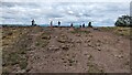
A univallate hillfort immediately to the east of Shrewsbury, situated upon Haughmond Hill.
It lies near the path running south from Haughmond Abbey, an Augustinian Abbey, now under the care of English Heritage.
Part of a rampart is vitrified - fused together by intense heat to increase strength (used in some Scottish hillforts such as Knockfarrel, Craig Phadraig, Finavon and Trusty's Hill, and Cronk Sumark on the Isle of Man). Here, it may be due to iron smelting, but it is not conclusive.
The construction of the ramparts also include materials not local to the site, which suggests to some that it may have been built upon an earlier structure.
The remaining ramparts are not that impressive, and to the unfamiliar, are not that obvious. The ramparts may well have not been finished.
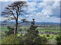
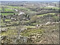
The hill can be clearly seen from the west. If in the car, the best fleeting view is from the stretch of A49 that lies within a meander of the River Severn, where the picture was taken.
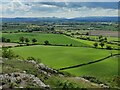
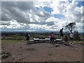
The views from the top are remarkable, with a wide panorama from the south east to the north west. Breiddin Hill, Cefn y Castell, The Wrekin, Caer Caradoc (Church Stretton), The Stiperstones, Earls Hill Camp, Grinshill, and more, are all visible.
The geology of Haughmond Hill is among the oldest stones one could get - 700-570 million years old Precambrian rocks; this is quarried on the north side of the hill, and known as greywacke and used in tarmac. One could be driving on road surfaces partially millions of years old from this site!
You may be viewing yesterday's version of this page. To see the most up to date information please register for a free account.
")
")
Do not use the above information on other web sites or publications without permission of the contributor.
Nearby Images from Geograph Britain and Ireland:
©2023(licence)
©2021(licence)
©2021(licence)
©2020(licence)
©2023(licence)
The above images may not be of the site on this page, they are loaded from Geograph.
Please Submit an Image of this site or go out and take one for us!
Click here to see more info for this site
Nearby sites
Key: Red: member's photo, Blue: 3rd party photo, Yellow: other image, Green: no photo - please go there and take one, Grey: site destroyed
Download sites to:
KML (Google Earth)
GPX (GPS waypoints)
CSV (Garmin/Navman)
CSV (Excel)
To unlock full downloads you need to sign up as a Contributory Member. Otherwise downloads are limited to 50 sites.
Turn off the page maps and other distractions
Nearby sites listing. In the following links * = Image available
1.9km ENE 71° Upton Magna* Timber Circle (SJ555144)
2.7km NNE 19° Ebury Hillfort* Hillfort (SJ546164)
4.6km WSW 254° High Cross (Shrewsbury) Ancient Cross (SJ492126)
4.8km SW 225° Shrewsbury Orthodox Church* Cursus (SJ5026310469)
5.0km WSW 256° Shrewsbury Museum and Art Gallery* Museum (SJ488126)
6.9km SW 223° The Burgs* Hillfort (SJ48950873)
9.4km SSE 168° Cove Coppice* Barrow Cemetery (SJ555046)
10.1km N 349° Grinshill* Ancient Village or Settlement (SJ519237)
10.4km S 169° Stevenshill* Hillfort (SJ556036)
10.8km ESE 120° The Wrekin* Hillfort (SJ630083)
11.0km NE 48° Ellerdine Heath* Standing Stone (Menhir) (SJ6191821168)
11.6km ESE 118° Willow Moor Barrow Cemetary* Barrow Cemetery (SJ640083)
12.0km E 97° St Margarets Well (Telford) Holy Well or Sacred Spring (SJ656123)
12.4km ENE 74° Kynnersley Burnt Mounds Artificial Mound (SJ657171)
13.0km S 181° The Frog Well Holy Well or Sacred Spring (SJ53340084)
13.6km NW 304° Baschurch Ring ditch* Ancient Village or Settlement (SJ425215)
14.3km NNE 16° Bury Walls* Hillfort (SJ577275)
14.5km NW 312° The Berth* Hillfort (SJ430236)
14.9km ENE 74° Wall Camp* Hillfort (SJ681178)
15.2km WSW 237° Pontesford Hill* Hillfort (SJ409056)
15.5km SSW 192° The Lawley (Northern)* Hillfort (SO50289863)
15.8km SW 234° Earls Hill Camp* Hillfort (SJ408047)
16.3km SSE 148° St Owens Well* Holy Well or Sacred Spring (SO622999)
16.3km WNW 289° Nesscliffe* Hillfort (SJ383193)
16.3km SSE 148° Holy Trinity (Much Wenlock)* Ancient Cross (SO623999)
View more nearby sites and additional images


 We would like to know more about this location. Please feel free to add a brief description and any relevant information in your own language.
 Wir möchten mehr über diese Stätte erfahren. Bitte zögern Sie nicht, eine kurze Beschreibung und relevante Informationen in Deutsch hinzuzufügen.
 Nous aimerions en savoir encore un peu sur les lieux. S'il vous plaît n'hesitez pas à ajouter une courte description et tous les renseignements pertinents dans votre propre langue.
 Quisieramos informarnos un poco más de las lugares. No dude en añadir una breve descripción y otros datos relevantes en su propio idioma.