<< Our Photo Pages >> The Howie of The Manse - Broch or Nuraghe in Scotland in Orkney
Submitted by howar on Sunday, 28 March 2004 Page Views: 7415
Iron Age and Later PrehistorySite Name: The Howie of The Manse Alternative Name: Loch of TankernessCountry: Scotland County: Orkney Type: Broch or Nuraghe
Nearest Town: Kirkwall
Map Ref: HY514090 Landranger Map Number: 6
Latitude: 58.965408N Longitude: 2.846795W
Condition:
| 5 | Perfect |
| 4 | Almost Perfect |
| 3 | Reasonable but with some damage |
| 2 | Ruined but still recognisable as an ancient site |
| 1 | Pretty much destroyed, possibly visible as crop marks |
| 0 | No data. |
| -1 | Completely destroyed |
| 5 | Superb |
| 4 | Good |
| 3 | Ordinary |
| 2 | Not Good |
| 1 | Awful |
| 0 | No data. |
| 5 | Can be driven to, probably with disabled access |
| 4 | Short walk on a footpath |
| 3 | Requiring a bit more of a walk |
| 2 | A long walk |
| 1 | In the middle of nowhere, a nightmare to find |
| 0 | No data. |
| 5 | co-ordinates taken by GPS or official recorded co-ordinates |
| 4 | co-ordinates scaled from a detailed map |
| 3 | co-ordinates scaled from a bad map |
| 2 | co-ordinates of the nearest village |
| 1 | co-ordinates of the nearest town |
| 0 | no data |
Internal Links:
External Links:
")
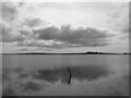
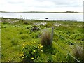
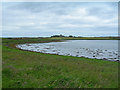
This broch sits on a small headland jutting out into the lower end of the Loch of Tankerness.Two ways to reach the site, neither straightforward and both requiring boots. One is to follow the mill stream and step on and over the wall where the stream comes to the loch shore, then follow the shoreline to your right. This way is very marshy and somewhat treacherous. An interesting feature of the wall is that ( on the one side of the stream at least ) it is formed of two courses of thin slabs set on end - this I would associate with the builders of the 19thC Mill as it looks rather out of place in Orkney to me .Over the stream is a most curious construction . Following the shoreline there are places where stones appear placed by the hand of man. Alternatively go up the hill from the Tankerness Mill and just round the road from Northwood House the sound of doves comes from Glebe . Go to the field that is directly behind this then downfield to the shore. It tends to be rather suckily muddy in many places. I would suggest going down the left-hand as the wall does a few strange things - there are two standing stones built into walls, one inside aligned with a wall and another at right angles to a wall ending it but lacking holes or other indications of having been a gatepost. Down at the bottom of this field there are a few 'sets' of large stones that would seem to represent former structures here ( in my opinion at least ) - I may be wrong but would note that at the Hall of Tankerness junction smack in the middle of a field stands a solitary standing stone with packing that does not appear on CANMORE either. To get to the headland requires going through a barbed wire fence, which fortunately has plenty of give in it or I'd never have managed it. It is one of the least prepossessing brochs I have seen, though at the seaward end it stands rather higher than the likes of Oxtro. At first sight I thought that there was nothing. Going towards it you can certainly feel plenty of apparently isolated stones hidden beneath the grass but no sense of stucture that I could tell. Coming to the highpoint and taking the line around you certainly get a strong feel for where the inner and outer walls were, going by the turf. Then I reached the top and there was a roughly rectangular depression. Looking on the inner side I made out several slabs in a non-radial line . So I did some rooting about and tearing off of the overhanging grass. Definitely a straight wall, remaining about six foot long and a foot or so high. The other side is less well defined, a few loose stones as far as I could tell and not so obviously slabs. If you go poking about then gloves are a necessity - the place is covered in almost invisibly short nettles. CANMORE mention several shallow sun- and rectangular banks S and W, and defensive remains 27m and 42m from the centre.
You may be viewing yesterday's version of this page. To see the most up to date information please register for a free account.
")
")
Do not use the above information on other web sites or publications without permission of the contributor.
Nearby Images from Geograph Britain and Ireland:
©2008(licence)
©2015(licence)
©2008(licence)

©2008(licence)
©2009(licence)
The above images may not be of the site on this page, they are loaded from Geograph.
Please Submit an Image of this site or go out and take one for us!
Click here to see more info for this site
Nearby sites
Key: Red: member's photo, Blue: 3rd party photo, Yellow: other image, Green: no photo - please go there and take one, Grey: site destroyed
Download sites to:
KML (Google Earth)
GPX (GPS waypoints)
CSV (Garmin/Navman)
CSV (Excel)
To unlock full downloads you need to sign up as a Contributory Member. Otherwise downloads are limited to 50 sites.
Turn off the page maps and other distractions
Nearby sites listing. In the following links * = Image available
582m SSW 210° Whitecleat* Holy Well or Sacred Spring (HY511085)
797m E 89° Grieves Cottage* Standing Stone (Menhir) (HY522090)
852m ENE 69° Loch of Tankerness* Ancient Village or Settlement (HY522093)
1.0km S 185° Mill Sand* Standing Stones (HY513080)
1.4km NNW 336° Yinstay* Ancient Village or Settlement (HY50841031)
1.8km SSE 163° Loch of Messigate* Standing Stones (HY519073)
1.8km E 85° Taing of Beeman* Ancient Village or Settlement (HY53210914)
2.3km SSW 195° Nearhouse* Ancient Village or Settlement (HY508068)
2.3km S 172° Muckle Crofty* Stone Row / Alignment (HY517067)
2.5km S 184° Hawell Burnt Mound* Round Barrow(s) (HY512065)
2.8km S 187° Stem Howe* Round Barrow(s) (HY510062)
2.9km S 183° Longhowe Cairn (HY512061)
3.0km S 186° Mine Howe* Chambered Cairn (HY5106406023)
3.0km S 189° Long Howe* Long Barrow (HY509060)
3.1km SSE 168° Breck Farm* Standing Stones (HY520060)
3.1km SW 227° Craw Howe* Cairn (HY491069)
3.1km S 191° Round Howe* Broch or Nuraghe (HY50780591)
3.2km SSW 192° Burn of Langskaill* Ancient Village or Settlement (HY507059)
3.2km SSW 199° Brymer* Round Barrow(s) (HY503060)
3.3km ENE 70° The Brough* Ancient Village or Settlement (HY545101)
3.3km ENE 68° Castle of Hangie Bay* Stone Fort or Dun (HY54461022)
3.7km SW 236° Staneloof* Cairn (HY48330698)
4.0km WNW 284° Berstane Broch* Broch or Nuraghe (HY475100)
4.1km SE 130° Hurnip's Point* Chambered Cairn (HY54480634)
4.1km W 262° Grimsquoy* Round Barrow(s) (HY473085)
View more nearby sites and additional images


 We would like to know more about this location. Please feel free to add a brief description and any relevant information in your own language.
 Wir möchten mehr über diese Stätte erfahren. Bitte zögern Sie nicht, eine kurze Beschreibung und relevante Informationen in Deutsch hinzuzufügen.
 Nous aimerions en savoir encore un peu sur les lieux. S'il vous plaît n'hesitez pas à ajouter une courte description et tous les renseignements pertinents dans votre propre langue.
 Quisieramos informarnos un poco más de las lugares. No dude en añadir una breve descripción y otros datos relevantes en su propio idioma.