 with our Megalithic Portal iPhone app")


<< Our Photo Pages >> Aconbury Hill - Hillfort in England in Herefordshire
Submitted by jfarrar on Monday, 14 October 2002 Page Views: 14707
Iron Age and Later PrehistorySite Name: Aconbury Hill Alternative Name: Caer RhainCountry: England County: Herefordshire Type: Hillfort
Nearest Town: Hereford Nearest Village: King's Thorn
Map Ref: SO504331
Latitude: 51.994120N Longitude: 2.723799W
Condition:
| 5 | Perfect |
| 4 | Almost Perfect |
| 3 | Reasonable but with some damage |
| 2 | Ruined but still recognisable as an ancient site |
| 1 | Pretty much destroyed, possibly visible as crop marks |
| 0 | No data. |
| -1 | Completely destroyed |
| 5 | Superb |
| 4 | Good |
| 3 | Ordinary |
| 2 | Not Good |
| 1 | Awful |
| 0 | No data. |
| 5 | Can be driven to, probably with disabled access |
| 4 | Short walk on a footpath |
| 3 | Requiring a bit more of a walk |
| 2 | A long walk |
| 1 | In the middle of nowhere, a nightmare to find |
| 0 | No data. |
| 5 | co-ordinates taken by GPS or official recorded co-ordinates |
| 4 | co-ordinates scaled from a detailed map |
| 3 | co-ordinates scaled from a bad map |
| 2 | co-ordinates of the nearest village |
| 1 | co-ordinates of the nearest town |
| 0 | no data |
Internal Links:
External Links:
I have visited· I would like to visit
Chrus visited on 1st Jan 2025 - their rating: Cond: 3 Amb: 4 Access: 3
")
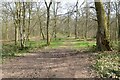
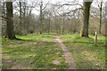
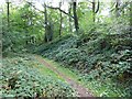
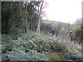
Pottery found on the site indicates it was permanently occupied from the 2nd century BCE until after the Roman Conquest. The interior of the camp is wooded and a path leads up to its highest point where there is a triangulation point – rather redundant given the density of the trees.
You may be viewing yesterday's version of this page. To see the most up to date information please register for a free account.
")
")
")
Do not use the above information on other web sites or publications without permission of the contributor.
Nearby Images from Geograph Britain and Ireland:
©2022(licence)
©2022(licence)
©2023(licence)

©2026(licence)
©2011(licence)
The above images may not be of the site on this page, they are loaded from Geograph.
Please Submit an Image of this site or go out and take one for us!
Click here to see more info for this site
Nearby sites
Key: Red: member's photo, Blue: 3rd party photo, Yellow: other image, Green: no photo - please go there and take one, Grey: site destroyed
Download sites to:
KML (Google Earth)
GPX (GPS waypoints)
CSV (Garmin/Navman)
CSV (Excel)
To unlock full downloads you need to sign up as a Contributory Member. Otherwise downloads are limited to 50 sites.
Turn off the page maps and other distractions
Nearby sites listing. In the following links * = Image available
817m ENE 69° St Ann's Well (Aconbury)* Holy Well or Sacred Spring (SO51173338)
1.9km SSE 155° Higgin's Well* Holy Well or Sacred Spring (SO51163141)
2.5km NE 39° Holy Well (Dinedor)* Holy Well or Sacred Spring (SO52013501)
3.9km NNE 31° Dinedor Camp* Hillfort (SO524364)
4.1km NNE 23° Rotherwas Ribbon* Ancient Trackway (SO52053690)
6.4km WSW 246° Kilpeck church* Early Christian Sculptured Stone (SO44513051)
6.6km N 6° St Ethelbert's Well (Hereford)* Holy Well or Sacred Spring (SO5112239684)
6.7km N 3° The King's Ditch Natural Stone / Erratic / Other Natural Feature (SO50873974)
6.8km N 4° Hereford Museum and Art Gallery* Museum (SO5090039851)
7.6km ENE 73° Cherry Hill* Hillfort (SO577352)
8.0km NW 321° Eaton Camp* Promontory Fort / Cliff Castle (SO454393)
8.6km SE 139° Picts Cross Stone (Sellack) Standing Stone (Menhir) (SO560266)
8.9km E 91° Capler Camp* Hillfort (SO593329)
8.9km S 185° St Weonard's Burial Mound Artificial Mound (SO495242)
10.1km NE 54° Backbury* Hillfort (SO587389)
10.2km SW 216° Garway Hill* Long Barrow (SO44232492)
10.9km NW 322° Holy Well (Swainshill)* Holy Well or Sacred Spring (SO43724177)
11.2km NNE 13° The Wergin's Stone* Standing Stone (Menhir) (SO5297543981)
11.3km W 273° Dunseal* Round Barrow(s) (SO391338)
11.5km ESE 112° Holy Well (Hole in the wall)* Holy Well or Sacred Spring (SO6109028682)
11.7km SSW 204° Holy Well (Garway)* Holy Well or Sacred Spring (SO4547122500)
11.8km W 262° Minns Close Tump Wood* Causewayed Enclosure (SO38693162)
12.2km WNW 287° Timberline Camp Hillfort (SO387367)
12.3km SSE 167° St Deinst (Llangarron)* Early Christian Sculptured Stone (SO531211)
12.5km NE 52° St Edith's Well (Herefordshire)* Holy Well or Sacred Spring (SO604406)
View more nearby sites and additional images


 We would like to know more about this location. Please feel free to add a brief description and any relevant information in your own language.
 Wir möchten mehr über diese Stätte erfahren. Bitte zögern Sie nicht, eine kurze Beschreibung und relevante Informationen in Deutsch hinzuzufügen.
 Nous aimerions en savoir encore un peu sur les lieux. S'il vous plaît n'hesitez pas à ajouter une courte description et tous les renseignements pertinents dans votre propre langue.
 Quisieramos informarnos un poco más de las lugares. No dude en añadir una breve descripción y otros datos relevantes en su propio idioma.