<< Our Photo Pages >> Moor Divock 3 - Cairn in England in Cumbria
Submitted by TheCaptain on Tuesday, 30 December 2003 Page Views: 12476
Neolithic and Bronze AgeSite Name: Moor Divock 3Country: England County: Cumbria Type: Cairn
Nearest Town: Penrith Nearest Village: Helton
Map Ref: NY4936921917 Landranger Map Number: 90
Latitude: 54.589894N Longitude: 2.785027W
Condition:
| 5 | Perfect |
| 4 | Almost Perfect |
| 3 | Reasonable but with some damage |
| 2 | Ruined but still recognisable as an ancient site |
| 1 | Pretty much destroyed, possibly visible as crop marks |
| 0 | No data. |
| -1 | Completely destroyed |
| 5 | Superb |
| 4 | Good |
| 3 | Ordinary |
| 2 | Not Good |
| 1 | Awful |
| 0 | No data. |
| 5 | Can be driven to, probably with disabled access |
| 4 | Short walk on a footpath |
| 3 | Requiring a bit more of a walk |
| 2 | A long walk |
| 1 | In the middle of nowhere, a nightmare to find |
| 0 | No data. |
| 5 | co-ordinates taken by GPS or official recorded co-ordinates |
| 4 | co-ordinates scaled from a detailed map |
| 3 | co-ordinates scaled from a bad map |
| 2 | co-ordinates of the nearest village |
| 1 | co-ordinates of the nearest town |
| 0 | no data |
Internal Links:
External Links:
I have visited· I would like to visit
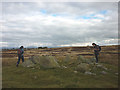
TheCaptain visited on 20th Sep 2022 - their rating: Cond: 2 Amb: 3 Access: 3 From MD4 I head back to the main trackway, where my attention is drawn to a couple of large stones laying just off the trackway to the right. I wonder if this was once a cairn with a few kerbstones. I look at the portal again, and see a cup marked stone somewhere around here, and wonder if it is that? No, its not that, which is marked further to the north. Thinking back now home, three weeks later and having got the old plan in front of me, I wonder if this is the remains of MD3. Unlike me, I did not take or keep any pictures of this, probably convinced that there was nothing of any ancient importance at this place! Doh!
SandyG visited on 8th Sep 2017 - their rating: Cond: 4 Amb: 4 Access: 3
Anne T visited on 28th Jun 2014 - their rating: Cond: 3 Amb: 4 Access: 3 After visiting the Cop Stone, we walked up to the Cairn Circle (which is clearly visible from the footpath). Whilst ruined, it's atmospheric. The more I sat on the edge of the cairn and looked round, the more there is to see. I'd like to go round with someone who knows this area better than I, so I can understand it better. [Note: I originally confused this with Moor Divock 4, the cairn circle and small stone row just to the north. Looking back on my photographs, I could find no evidence of this feature on the ground].
nicoladidsbury have visited here
Average ratings for this site from all visit loggers: Condition: 3 Ambience: 3.67 Access: 3
")
Described as being "50 yards to the north of these remains [Moor Divock 2] and about forty yards from a township boundary stone standing by the side of the roadway, there are relics of what has evidently been a small stone circle and cairn about 11 feet in diameter. Some of the stones may be fixed and in situ, but it is difficult to judge how many are so placed, for it is manifest that the place has been rifled in a very rude manner, and several of the larger stones have been dislodged, and the smaller stones forming the pavement of the cairn have been scattered about, whilst there is still remaining the de-pression in the centre, where the digging had been carried on."
This site is not recorded by Historic England.
You may be viewing yesterday's version of this page. To see the most up to date information please register for a free account.
")
")
Do not use the above information on other web sites or publications without permission of the contributor.
Nearby Images from Geograph Britain and Ireland:

©2016(licence)

©2017(licence)

©2012(licence)
©2012(licence)

©2018(licence)
The above images may not be of the site on this page, they are loaded from Geograph.
Please Submit an Image of this site or go out and take one for us!
Click here to see more info for this site
Nearby sites
Key: Red: member's photo, Blue: 3rd party photo, Yellow: other image, Green: no photo - please go there and take one, Grey: site destroyed
Download sites to:
KML (Google Earth)
GPX (GPS waypoints)
CSV (Garmin/Navman)
CSV (Excel)
To unlock full downloads you need to sign up as a Contributory Member. Otherwise downloads are limited to 50 sites.
![]()
Turn off the page maps and other distractions
Nearby sites listing. In the following links * = Image available
48m NE 44° Askham Fell Cairn Stone Row* Stone Row / Alignment (NY4940321951)
53m NE 35° Moor Divock 4* Stone Circle (NY49402196)
108m NW 320° Moor Divock carved stone* Rock Art (NY493220)
116m N 1° Moor Divock 4 to 5 Stone Avenue Stone Row / Alignment (NY4937322033)
133m SE 130° Moor Divock 2* Standing Stones (NY49472183)
197m E 84° Askham Fell Round Cairn B Round Cairn (NY4956621935)
214m E 100° Askham Fell Round Cairn A Round Cairn (NY4958021879)
244m N 350° Moor Divock Round Cairn C Cairn (NY4933022158)
249m NW 317° Moor Divock* Multiple Stone Rows / Avenue (NY492221)
274m NNW 345° Moor Divock 5* Cairn (NY4930322183)
295m NNW 345° Moor Divock Round Cairn D* Cairn (NY4929822204)
324m SSW 192° Moor Divock Cairn* Cairn (NY493216)
386m NNW 332° Moor Divock 6, 7 and 8 Cairn (NY49192226)
388m NW 309° Moor Divock* Cairn (NY4907122166)
392m SE 143° Cop Stone* Standing Stone (Menhir) (NY49602160)
449m NNW 329° Moor Divock 9 Cairn (NY4914122304)
450m NNW 329° Askham Fell Stone Row* Stone Row / Alignment (NY4914322307)
552m NNW 330° Askham Fell* Cairn (NY491224)
700m NW 320° Moor Divock Cairn E Cairn (NY4892522460)
722m NW 317° White Raise Cairn* Cairn (NY48882245)
820m NW 314° Moor Divock 12 Cairn (NY48782249)
822m NW 314° Moor Divock 11 Cairn (NY4878522498)
826m NW 321° Moor Divock Cairn F Cairn (NY4885422564)
854m W 281° Moor Divock Round Cairns K1, K2 and K3 Round Cairn (NY4853122092)
885m N 355° Hag Stones (Moor Divock) Misc. Earthwork (NY493228)
View more nearby sites and additional images


 We would like to know more about this location. Please feel free to add a brief description and any relevant information in your own language.
 Wir möchten mehr über diese Stätte erfahren. Bitte zögern Sie nicht, eine kurze Beschreibung und relevante Informationen in Deutsch hinzuzufügen.
 Nous aimerions en savoir encore un peu sur les lieux. S'il vous plaît n'hesitez pas à ajouter une courte description et tous les renseignements pertinents dans votre propre langue.
 Quisieramos informarnos un poco más de las lugares. No dude en añadir una breve descripción y otros datos relevantes en su propio idioma.