

<< Our Photo Pages >> Mossthorn Long Cairn 2 - Cairn in England in Cumbria
Submitted by Anne T on Monday, 13 February 2017 Page Views: 2052
Neolithic and Bronze AgeSite Name: Mossthorn Long Cairn 2 Alternative Name: Copt Howe 2; Newton Reigny IICountry: England County: Cumbria Type: Cairn
Nearest Town: Penrith Nearest Village: Newton Reigny / Greystoke / Newbeggin
Map Ref: NY4828930440
Latitude: 54.666370N Longitude: 2.803246W
Condition:
| 5 | Perfect |
| 4 | Almost Perfect |
| 3 | Reasonable but with some damage |
| 2 | Ruined but still recognisable as an ancient site |
| 1 | Pretty much destroyed, possibly visible as crop marks |
| 0 | No data. |
| -1 | Completely destroyed |
| 5 | Superb |
| 4 | Good |
| 3 | Ordinary |
| 2 | Not Good |
| 1 | Awful |
| 0 | No data. |
| 5 | Can be driven to, probably with disabled access |
| 4 | Short walk on a footpath |
| 3 | Requiring a bit more of a walk |
| 2 | A long walk |
| 1 | In the middle of nowhere, a nightmare to find |
| 0 | No data. |
| 5 | co-ordinates taken by GPS or official recorded co-ordinates |
| 4 | co-ordinates scaled from a detailed map |
| 3 | co-ordinates scaled from a bad map |
| 2 | co-ordinates of the nearest village |
| 1 | co-ordinates of the nearest town |
| 0 | no data |
Internal Links:
External Links:
I have visited· I would like to visit
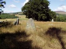
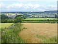
Anne T saw from a distance on 20th Nov 2017 - their rating: Cond: 2 Amb: 3 Access: 3 Mossthorn Long Cairn 2, Copt Howe, Newton Reigny: See the visit report for Mossthorn Long Cairn 1 for more details. This is the side of the long cairn (or natural feature, as Pastscape says?) we couldn’t see from the road on our last visit on 12th February 2017. This time, we could only see it from the field boundary near the southern end of Mossthorn Long Cairn 1. From this angle, it does look like a natural hummock, although more like a cairn from the main road.
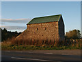
Anne T visited on 12th Feb 2017 - their rating: Cond: 3 Amb: 3 Access: 5 Long Cairns near Mossthorn Farm, near Sewborwens Standing Stones: From Sewborwens Standing Stone(s), we drove westwards along this minor road, through the roadworks currently there, and parked in the layby outside The Wreay. The first long cairn is visible in the field immediately opposite.
Crossing the road to photograph this site, the wind chill must have been -5 degrees C, with the occasional flake of sleet. The roadworks had churned up the grass, so I waded through almost ankle deep mud to the stone wall and got a closer photograph.
We didn’t realise there was a second cairn at grid reference NY 48258 30606 until I checked on the Historic England site.
Given we want to come back and track the standing stones in Newbeggin Village at some point, I’m going to write to the farm to ask permission to walk the fields to see both long cairns at closer quarters.
Average ratings for this site from all visit loggers: Condition: 2.5 Ambience: 3 Access: 4
")
This is the second of two long cairns sited near Mossthorn Farm, not far from Sewborwens Standing Stone(s) and visible from the road.
Scheduled as Historic England List ID 1012819, this long cairn is sited 370 metres east south east of Mossthorn Farm, on private land.
Historic England dates this site to the Neolithic and tells us that the long cairn visible from the road is partly multilated and lies "at the extreme southern end of Copt How ridge, from where the ground falls steeply on the west and south sides to a small stream and less steeply on the east side. It includes a turf-covered mound of cobbles and earth up to 4m high measuring c. 50m east-west by 43m north-south. A number of urns were reportedly discovered here several years ago but their present whereabouts is unknown ….. Despite some plough clipping on the monument's western side, this ...... (cairn) survives reasonably well.
Also recorded as Pastscape Monument No. 11279, Pastscape initially records this as a long cairn, but concludes "a mound N/S is evident, but it is almost certain that the whole is a natural feature. A prominent break of slope at the south end is likely to be the result of a former field boundary, and the west side has been disturbed by quarrying. No evidence for previously noted heavy stone content."
You may be viewing yesterday's version of this page. To see the most up to date information please register for a free account.
")
Do not use the above information on other web sites or publications without permission of the contributor.
Nearby Images from Geograph Britain and Ireland:
©2016(licence)
©2006(licence)
©2015(licence)
©2011(licence)
©2016(licence)
The above images may not be of the site on this page, they are loaded from Geograph.
Please Submit an Image of this site or go out and take one for us!
Click here to see more info for this site
Nearby sites
Key: Red: member's photo, Blue: 3rd party photo, Yellow: other image, Green: no photo - please go there and take one, Grey: site destroyed
Download sites to:
KML (Google Earth)
GPX (GPS waypoints)
CSV (Garmin/Navman)
CSV (Excel)
To unlock full downloads you need to sign up as a Contributory Member. Otherwise downloads are limited to 50 sites.
Turn off the page maps and other distractions
Nearby sites listing. In the following links * = Image available
169m N 349° Mossthorn Long Cairn 1* Cairn (NY4825830606)
710m SE 129° Sewborrans Stone* Standing Stone (Menhir) (NY48842999)
937m SSW 194° Newbeggin Stone Row (Possible)* Standing Stone (Menhir) (NY4805829531)
1.2km N 352° Newton Reigny Enclosure* Misc. Earthwork (NY4814031590)
1.3km NW 323° Newton Reigny Stone Row / Alignment (NY475315)
1.6km SW 225° Newbeggin Stone Row (Stone 1)* Standing Stone (Menhir) (NY4712629292)
1.6km SW 225° Newbeggin Stone Row* Stone Row / Alignment (NY47122929)
1.7km SW 227° Newbeggin Stone Row (Stone 3)* Standing Stone (Menhir) (NY4703929314)
1.7km SW 225° Newbeggin Stone Row (Stone 2)* Standing Stone (Menhir) (NY4705629248)
1.8km W 279° Kells Well (Newbeggin)* Holy Well or Sacred Spring (NY4654330728)
1.8km SW 219° Newbeggin Wells* Holy Well or Sacred Spring (NY47122902)
1.8km SW 218° Newbeggin Stone Row (Blue Stone)* Natural Stone / Erratic / Other Natural Feature (NY4713029010)
2.0km SW 222° Newbeggin Stone Row (Stone 4)* Standing Stone (Menhir) (NY4692428953)
2.1km SE 128° Bell Mount* Natural Stone / Erratic / Other Natural Feature (NY49932914)
2.1km SW 222° Newbeggin Stone Row (Stone 5)* Standing Stone (Menhir) (NY4684928893)
2.9km SSE 158° Dacre Parish* Stone Circle (NY49342771)
3.1km SSE 168° Snuff Mill (Stainton)* Standing Stone (Menhir) (NY4890927405)
3.2km E 91° Penrith Museum* Museum (NY5144830339)
3.2km ESE 122° Skirsgill Standing Stone* Standing Stone (Menhir) (NY50972875)
3.3km SE 125° Skirsgill Holy Well (Skirsgill) Holy Well or Sacred Spring (NY5095028560)
3.3km SE 144° Redhills Rock Art* Rock Art (NY50192776)
3.4km E 94° Giants Grave, Penrith* Ancient Cross (NY51653017)
3.8km ESE 103° Plague Stone (Penrith)* Ancient Cross (NY5196329563)
4.0km W 274° Sanctuary Stone (Greystoke)* Early Christian Sculptured Stone (NY4433530785)
4.1km NNE 18° Lowhouse* Stone Circle (NY49623435)
View more nearby sites and additional images


 We would like to know more about this location. Please feel free to add a brief description and any relevant information in your own language.
 Wir möchten mehr über diese Stätte erfahren. Bitte zögern Sie nicht, eine kurze Beschreibung und relevante Informationen in Deutsch hinzuzufügen.
 Nous aimerions en savoir encore un peu sur les lieux. S'il vous plaît n'hesitez pas à ajouter une courte description et tous les renseignements pertinents dans votre propre langue.
 Quisieramos informarnos un poco más de las lugares. No dude en añadir una breve descripción y otros datos relevantes en su propio idioma.