
, Aubrey Burl")
<< Text Pages >> Windy Edge Stone - Stone Circle in Scotland in Dumfries and Galloway
Submitted by markj99 on Tuesday, 11 April 2023 Page Views: 847
Neolithic and Bronze AgeSite Name: Windy Edge StoneCountry: Scotland
NOTE: This site is 0.6 km away from the location you searched for.
County: Dumfries and Galloway Type: Stone Circle
Nearest Town: Langholm Nearest Village: Newcastleton
Map Ref: NY43048389
Latitude: 55.146063N Longitude: 2.895213W
Condition:
| 5 | Perfect |
| 4 | Almost Perfect |
| 3 | Reasonable but with some damage |
| 2 | Ruined but still recognisable as an ancient site |
| 1 | Pretty much destroyed, possibly visible as crop marks |
| 0 | No data. |
| -1 | Completely destroyed |
| 5 | Superb |
| 4 | Good |
| 3 | Ordinary |
| 2 | Not Good |
| 1 | Awful |
| 0 | No data. |
| 5 | Can be driven to, probably with disabled access |
| 4 | Short walk on a footpath |
| 3 | Requiring a bit more of a walk |
| 2 | A long walk |
| 1 | In the middle of nowhere, a nightmare to find |
| 0 | No data. |
| 5 | co-ordinates taken by GPS or official recorded co-ordinates |
| 4 | co-ordinates scaled from a detailed map |
| 3 | co-ordinates scaled from a bad map |
| 2 | co-ordinates of the nearest village |
| 1 | co-ordinates of the nearest town |
| 0 | no data |
Internal Links:
External Links:
I have visited· I would like to visit
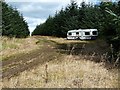
markj99 visited on 26th May 2012 - their rating: Cond: 2 Amb: 5 Access: 1 The effort required to reach Windy Edge monuments is rewarded by their splendid isolation.
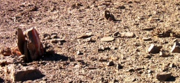
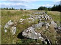
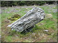
According to Canmore ID 67908, this standing stone is one of two survivors of a destroyed stone circle. The second stone lies c. 130 feet SSE at NY 43052 83863. At the time of my visit I wasn't aware of the second stone. I assumed Windy Edge Stone was a solitary Standing Stone.
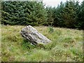
The N stone, situated in open moorland on the edge of a pine forest, has a c. 45° lean to the N. The stone slab measures c. 4.5 x 3.5 x 1 feet with an actual height of c. 3 feet due to the angle.
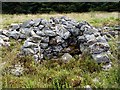
The S stone, according to Canmore ID 67908, leans to the N, measures "1.7m long, 1.2m wide, 0.6m thick" and "is situated in dense forestry."
You may be viewing yesterday's version of this page. To see the most up to date information please register for a free account.
")
")
")
")
Do not use the above information on other web sites or publications without permission of the contributor.
Nearby Images from Geograph Britain and Ireland:
©2012(licence)
©2012(licence)
©2012(licence)
©2006(licence)
©2012(licence)
The above images may not be of the site on this page, they are loaded from Geograph.
Please Submit an Image of this site or go out and take one for us!
Click here to see more info for this site
Nearby sites
Key: Red: member's photo, Blue: 3rd party photo, Yellow: other image, Green: no photo - please go there and take one, Grey: site destroyed
Download sites to:
KML (Google Earth)
GPX (GPS waypoints)
CSV (Garmin/Navman)
CSV (Excel)
To unlock full downloads you need to sign up as a Contributory Member. Otherwise downloads are limited to 50 sites.
Turn off the page maps and other distractions
Nearby sites listing. In the following links * = Image available
92m WNW 282° Windy Edge* Chambered Cairn (NY42958391)
140m W 273° Windy Edge* Chambered Cairn (NY429839)
1.3km N 2° Tinnis Well* Holy Well or Sacred Spring (NY431852)
1.6km N 1° Tinnis Hill* Cairn (NY43098545)
4.6km E 100° Will O'Greena's Stane* Standing Stone (Menhir) (NY47578303)
5.1km ENE 63° Milnholm (Newcastleton)* Ancient Cross (NY4763986111)
6.0km E 85° Carby Hill* Ancient Village or Settlement (NY4906084360)
6.6km W 274° Langholm Market Cross* Ancient Cross (NY36488447)
7.2km SW 221° Gilnochie Tower rock art* Rock Art (NY3823178559)
7.5km SSE 158° Priest's Well (Catlowdy)* Holy Well or Sacred Spring (NY4573976887)
8.7km WNW 296° Barntalloch (Langholm)* Misc. Earthwork (NY35258776)
9.0km SSE 157° Holywell (Catlowdy)* Holy Well or Sacred Spring (NY4649175570)
9.0km SSE 158° Solport Holy Well (Catlowdy) Holy Well or Sacred Spring (NY4637075490)
10.0km NE 52° Old Castleton (Newcastleton)* Misc. Earthwork (NY50978997)
10.0km NE 53° Castleton (Newcastleton)* Ancient Cross (NY51108983)
10.1km WNW 294° Little Hill (Craig)* Hillfort (NY3383088160)
10.4km NNW 328° Grey Wether Meikledale Standing Stone (Menhir) (NY3761692734)
10.6km WSW 250° Bloch Well (Langholm)* Holy Well or Sacred Spring (NY33018034)
11.6km SSW 202° Scots' Dike* Misc. Earthwork (NY38507325)
12.5km SSW 197° St Andrew's Well (Kirkandrews-on-Esk) Holy Well or Sacred Spring (NY3913071970)
12.8km SSW 195° Castra Exploratorum Ancient Village or Settlement (NY39607160)
13.3km WNW 289° Shaw Hill (Westerkirk) Hillfort (NY30458834)
13.5km WNW 296° Westerkirk Stone Circle (NY3190)
14.0km WNW 295° Boonies Ancient Village or Settlement (NY304900)
14.4km NNE 30° The Buck Stone (Buckstone Rig)* Standing Stone (Menhir) (NY50509622)
View more nearby sites and additional images


 We would like to know more about this location. Please feel free to add a brief description and any relevant information in your own language.
 Wir möchten mehr über diese Stätte erfahren. Bitte zögern Sie nicht, eine kurze Beschreibung und relevante Informationen in Deutsch hinzuzufügen.
 Nous aimerions en savoir encore un peu sur les lieux. S'il vous plaît n'hesitez pas à ajouter une courte description et tous les renseignements pertinents dans votre propre langue.
 Quisieramos informarnos un poco más de las lugares. No dude en añadir una breve descripción y otros datos relevantes en su propio idioma.