


<< Our Photo Pages >> Pyon Wood - Hillfort in England in Herefordshire
Submitted by vicky on Monday, 14 October 2002 Page Views: 11356
Iron Age and Later PrehistorySite Name: Pyon WoodCountry: England
NOTE: This site is 3.22 km away from the location you searched for.
County: Herefordshire Type: Hillfort
Map Ref: SO424664 Landranger Map Number: 137
Latitude: 52.292697N Longitude: 2.845955W
Condition:
| 5 | Perfect |
| 4 | Almost Perfect |
| 3 | Reasonable but with some damage |
| 2 | Ruined but still recognisable as an ancient site |
| 1 | Pretty much destroyed, possibly visible as crop marks |
| 0 | No data. |
| -1 | Completely destroyed |
| 5 | Superb |
| 4 | Good |
| 3 | Ordinary |
| 2 | Not Good |
| 1 | Awful |
| 0 | No data. |
| 5 | Can be driven to, probably with disabled access |
| 4 | Short walk on a footpath |
| 3 | Requiring a bit more of a walk |
| 2 | A long walk |
| 1 | In the middle of nowhere, a nightmare to find |
| 0 | No data. |
| 5 | co-ordinates taken by GPS or official recorded co-ordinates |
| 4 | co-ordinates scaled from a detailed map |
| 3 | co-ordinates scaled from a bad map |
| 2 | co-ordinates of the nearest village |
| 1 | co-ordinates of the nearest town |
| 0 | no data |
Internal Links:
External Links:
")
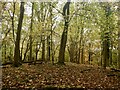
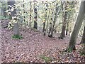
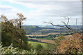
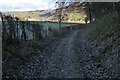
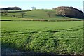
An overgrown track leads up into the hill fort. A large rampart has an entrance on the north-eastern side of the hill, although there is doubt this is an original entrance. Much of the ramparts, there being two, have been destroyed over the years. The top of the hill is a triangular hump, seeming hardly a good site for a settlement. Although there are no “Keep Out” signs, the whole ambience is far from welcoming.
You may be viewing yesterday's version of this page. To see the most up to date information please register for a free account.
")
Do not use the above information on other web sites or publications without permission of the contributor.
Nearby Images from Geograph Britain and Ireland:
©2021(licence)
©2021(licence)
©2008(licence)
©2023(licence)
©2023(licence)
The above images may not be of the site on this page, they are loaded from Geograph.
Please Submit an Image of this site or go out and take one for us!
Click here to see more info for this site
Nearby sites
Key: Red: member's photo, Blue: 3rd party photo, Yellow: other image, Green: no photo - please go there and take one, Grey: site destroyed
Download sites to:
KML (Google Earth)
GPX (GPS waypoints)
CSV (Garmin/Navman)
CSV (Excel)
To unlock full downloads you need to sign up as a Contributory Member. Otherwise downloads are limited to 50 sites.
Turn off the page maps and other distractions
Nearby sites listing. In the following links * = Image available
1.3km S 172° St John the Baptist and St Alkmund (Aymestrey)* Ancient Cross (SO4256065130)
2.0km ENE 78° Croft Ambrey* Hillfort (SO444668)
3.0km E 95° Bircher Common* Misc. Earthwork (SO454661)
5.6km SSE 155° St Michael's Church (Kingsland)* Ancient Cross (SO4468461269)
6.4km NNW 338° Brandon Camp* Hillfort (SO401724)
6.9km ESE 115° Luston Holy Well* Holy Well or Sacred Spring (SO4859563407)
8.3km NW 309° Brampton Bryan Lady Well* Holy Well or Sacred Spring (SO36007172)
8.7km WSW 243° Wapley Camp* Hillfort (SO3457162465)
9.0km NE 48° Haye Park Wood Enclosure* Ancient Village or Settlement (SO49167229)
9.1km NW 320° Coxall Knoll* Hillfort (SO366734)
9.4km NNW 342° Leintwardine Cursus Cursus (SO39577534)
9.6km WSW 253° Cat and Fiddle Enclosure Cropmark Ancient Village or Settlement (SO33146362)
10.1km W 262° Stapleton Henge Henge (SO32356510)
11.0km W 259° St Andrew's Church (Presteigne)* Ancient Cross (SO3156864528)
11.5km SSW 209° Tank Cottage Standing Stone (Menhir) (SO36615640)
11.8km NW 323° Castle Ditches (Shropshire)* Ancient Village or Settlement (SO35357594)
12.0km NE 46° Ludlow Museum* Museum (SO512746)
12.1km NE 43° Boiling Well (Ludlow)* Holy Well or Sacred Spring (SO508752)
12.3km WNW 287° Spaceguard Centre* Modern Stone Circle etc (SO3066970104)
12.8km NE 47° St Julian's Well (Ludlow)* Holy Well or Sacred Spring (SO5184275060)
13.1km NW 321° Great Hagley* Standing Stone (Menhir) (SO343767)
13.1km SSE 152° Ivington Camp* Hillfort (SO484547)
13.2km NNE 29° Robin Hoods Butt 1 (Shropshire) Round Barrow(s) (SO48977787)
13.2km NNE 32° Bromfield Barrows* Barrow Cemetery (SO495776)
13.7km ESE 116° Bach Camp* Hillfort (SO546602)
View more nearby sites and additional images


 We would like to know more about this location. Please feel free to add a brief description and any relevant information in your own language.
 Wir möchten mehr über diese Stätte erfahren. Bitte zögern Sie nicht, eine kurze Beschreibung und relevante Informationen in Deutsch hinzuzufügen.
 Nous aimerions en savoir encore un peu sur les lieux. S'il vous plaît n'hesitez pas à ajouter une courte description et tous les renseignements pertinents dans votre propre langue.
 Quisieramos informarnos un poco más de las lugares. No dude en añadir una breve descripción y otros datos relevantes en su propio idioma.