<< Our Photo Pages >> Cairn of Humster - Broch or Nuraghe in Scotland in Caithness
Submitted by SolarMegalith on Friday, 12 November 2010 Page Views: 4438
Iron Age and Later PrehistorySite Name: Cairn of HumsterCountry: Scotland County: Caithness Type: Broch or Nuraghe
Nearest Town: Wick Nearest Village: Humster
Map Ref: ND35294848
Latitude: 58.419857N Longitude: 3.109451W
Condition:
| 5 | Perfect |
| 4 | Almost Perfect |
| 3 | Reasonable but with some damage |
| 2 | Ruined but still recognisable as an ancient site |
| 1 | Pretty much destroyed, possibly visible as crop marks |
| 0 | No data. |
| -1 | Completely destroyed |
| 5 | Superb |
| 4 | Good |
| 3 | Ordinary |
| 2 | Not Good |
| 1 | Awful |
| 0 | No data. |
| 5 | Can be driven to, probably with disabled access |
| 4 | Short walk on a footpath |
| 3 | Requiring a bit more of a walk |
| 2 | A long walk |
| 1 | In the middle of nowhere, a nightmare to find |
| 0 | No data. |
| 5 | co-ordinates taken by GPS or official recorded co-ordinates |
| 4 | co-ordinates scaled from a detailed map |
| 3 | co-ordinates scaled from a bad map |
| 2 | co-ordinates of the nearest village |
| 1 | co-ordinates of the nearest town |
| 0 | no data |
Internal Links:
External Links:
I have visited· I would like to visit
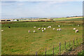
SolarMegalith visited on 6th Jul 2011 - their rating: Cond: 2 Amb: 4 Access: 3 Access to the broch is limited by fences.
")
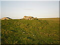
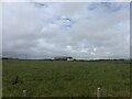
The site called "Cairn of Humster" is actually a possible broch which appears now as a grassy mound with no traces of stone construction visible. The mound's diameter is 30 metres, there are also some remains of a ditch.
You may be viewing yesterday's version of this page. To see the most up to date information please register for a free account.
")
")
")
Do not use the above information on other web sites or publications without permission of the contributor.
Nearby Images from Geograph Britain and Ireland:
©2021(licence)
©2023(licence)
©2021(licence)
©2022(licence)
©2007(licence)
The above images may not be of the site on this page, they are loaded from Geograph.
Please Submit an Image of this site or go out and take one for us!
Click here to see more info for this site
Nearby sites
Key: Red: member's photo, Blue: 3rd party photo, Yellow: other image, Green: no photo - please go there and take one, Grey: site destroyed
Download sites to:
KML (Google Earth)
GPX (GPS waypoints)
CSV (Garmin/Navman)
CSV (Excel)
To unlock full downloads you need to sign up as a Contributory Member. Otherwise downloads are limited to 50 sites.
Turn off the page maps and other distractions
Nearby sites listing. In the following links * = Image available
1.3km S 187° Hempriggs Broch* Broch or Nuraghe (ND35114717)
1.9km SSE 151° Hempriggs Chambered Cairn* Chambered Cairn (ND36174680)
2.4km WSW 243° Cairnquoy* Broch or Nuraghe (ND33094743)
3.0km SSW 208° Thrumster Little Broch* Broch or Nuraghe (ND33844583)
3.1km WSW 250° Tannach Mains* Broch or Nuraghe (ND32364748)
3.3km NNW 345° Fairy Hillock (Milton) Cairn (ND34465173)
3.4km N 354° Kettleburn Broch Broch or Nuraghe (ND34975191)
3.7km NE 38° The Pap* Broch or Nuraghe (ND37625140)
4.0km SSW 210° Thrumster Mains* Broch or Nuraghe (ND3319545059)
4.0km SSW 200° Gansclet Standing Stone* Standing Stone (Menhir) (ND33824473)
4.4km SSW 201° Gansclet Broch Broch or Nuraghe (ND3362744415)
4.4km NE 41° Papigoe Broch or Nuraghe (ND38285176)
4.9km NE 43° Cairn of Elsay* Broch or Nuraghe (ND38715198)
5.5km SSW 205° Borrowston Broch* Broch or Nuraghe (ND3288143536)
5.8km N 359° Ackergill Mains* Standing Stone (Menhir) (ND35285424)
5.8km SSW 210° Brounaban* Broch or Nuraghe (ND3231243478)
5.9km N 11° Shorelands Broch or Nuraghe (ND36475425)
6.0km SW 223° Loch of Yarrows Crannog* Crannog (ND3114944161)
6.0km SW 221° Battle Moss Stone Rows* Multiple Stone Rows / Avenue (ND3128644027)
6.3km SW 215° McCole's Castle* Chambered Cairn (ND3161243364)
6.5km SW 216° Battle Moss Cairns* Cairn (ND31374333)
6.5km SSW 213° Whiteleen Standing Stones* Standing Stones (ND3163743111)
6.5km SSW 213° Whiteleen Cairn* Cairn (ND3165743081)
6.5km NNW 335° Norwall Broch* Broch or Nuraghe (ND32665445)
6.6km NW 307° Thuster Broch or Nuraghe (ND30045254)
View more nearby sites and additional images


 We would like to know more about this location. Please feel free to add a brief description and any relevant information in your own language.
 Wir möchten mehr über diese Stätte erfahren. Bitte zögern Sie nicht, eine kurze Beschreibung und relevante Informationen in Deutsch hinzuzufügen.
 Nous aimerions en savoir encore un peu sur les lieux. S'il vous plaît n'hesitez pas à ajouter une courte description et tous les renseignements pertinents dans votre propre langue.
 Quisieramos informarnos un poco más de las lugares. No dude en añadir una breve descripción y otros datos relevantes en su propio idioma.