<< Our Photo Pages >> Llanveyno Crosses - Ancient Cross in England in Herefordshire
Submitted by Sunny100 on Saturday, 03 July 2010 Page Views: 5914
Early Medieval (Dark Age)Site Name: Llanveyno Crosses Alternative Name: St Beuno's Cross, Llanveyno Crosses, Llanveynoe Cross; St Peter's ChurchCountry: England County: Herefordshire Type: Ancient Cross
Nearest Town: Hay On Wye Nearest Village: Llanveyno (Llanveynoe)
Map Ref: SO3031131361
Latitude: 51.976326N Longitude: 3.015984W
Condition:
| 5 | Perfect |
| 4 | Almost Perfect |
| 3 | Reasonable but with some damage |
| 2 | Ruined but still recognisable as an ancient site |
| 1 | Pretty much destroyed, possibly visible as crop marks |
| 0 | No data. |
| -1 | Completely destroyed |
| 5 | Superb |
| 4 | Good |
| 3 | Ordinary |
| 2 | Not Good |
| 1 | Awful |
| 0 | No data. |
| 5 | Can be driven to, probably with disabled access |
| 4 | Short walk on a footpath |
| 3 | Requiring a bit more of a walk |
| 2 | A long walk |
| 1 | In the middle of nowhere, a nightmare to find |
| 0 | No data. |
| 5 | co-ordinates taken by GPS or official recorded co-ordinates |
| 4 | co-ordinates scaled from a detailed map |
| 3 | co-ordinates scaled from a bad map |
| 2 | co-ordinates of the nearest village |
| 1 | co-ordinates of the nearest town |
| 0 | no data |
Internal Links:
External Links:
")
One of these shaped stones shows a crucifixion scene with Christ wearing a tunic. His arms stretched outwards on the cross and his feet are in a standing position. His head leans to one side. Also on this stone there are some small round holes or cup-marks. So it could be a pagan stone that has been Christianised. The other stone, next to it, has half an incised cross and some letters carved onto it, perhaps part of an inscription. The carvings may date from the 6th or 7th century.
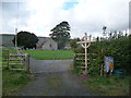
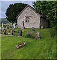
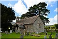
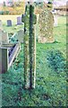
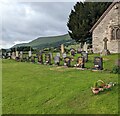
In the churchyard there is a short-armed thin cross some 5 foot high. It is probably Celtic in origin and pre-Conquest. A groove runs down the cross, as if it has been used as a water channel in more recent times. This cross was found in the 1870s and put back into the churchyard. St Beuno lived here in the early 7th century and may have founded a small monastery. He later went N and built 10 more churches in north Wales - his best known being Clynnog Fawr. He died there in 640 AD.
The church is also known as St Peter's and the crosses are scheduled as Historic England List ID 1078174 (cross approx. 5m south of the church) and List ID 1078173 (the church and two panels inset into the south wall of the nave). Pastscape Monument No. 105937 gives further details, including a further fragments which can be found inside the church.
The Journal of Antiquities also features a page for these crosses - see their entry for St Beuno’s Church, Llanveynoe, Herefordshire, which includes photographs of two of the carved stones, background information about the church and information about St Beuno.
You may be viewing yesterday's version of this page. To see the most up to date information please register for a free account.
")
")
")
Do not use the above information on other web sites or publications without permission of the contributor.
Nearby Images from Geograph Britain and Ireland:
©2012(licence)
©2022(licence)
©2017(licence)
©2015(licence)
©2022(licence)
The above images may not be of the site on this page, they are loaded from Geograph.
Please Submit an Image of this site or go out and take one for us!
Click here to see more info for this site
Nearby sites
Key: Red: member's photo, Blue: 3rd party photo, Yellow: other image, Green: no photo - please go there and take one, Grey: site destroyed
Download sites to:
KML (Google Earth)
GPX (GPS waypoints)
CSV (Garmin/Navman)
CSV (Excel)
To unlock full downloads you need to sign up as a Contributory Member. Otherwise downloads are limited to 50 sites.
Turn off the page maps and other distractions
Nearby sites listing. In the following links * = Image available
2.0km WNW 288° St. Thomas' Well* Holy Well or Sacred Spring (SO28433201)
2.0km SW 219° Crucorney Fawr 1 Round Cairn (SO290298)
2.2km SSW 206° Crucorney Fawr 2 Round Cairn (SO293294)
2.7km S 189° Wiral Cairn* Cairn (SO2985028710)
4.5km SSE 148° Clodock Inscribed Stone* Carving (SO32642751)
4.6km SSE 148° St. Clodock's Well* Holy Well or Sacred Spring (SO32692738)
4.8km W 266° Capel-y-ffin Standing Stone (Menhir) (SO2550031118)
5.9km N 360° Wern Derys* Standing Stone (Menhir) (SO30363726)
6.1km W 271° Darren Esgob* Stone Circle (SO242315)
6.3km SSW 200° Garn Wen (Monmouthshire)* Stone Circle (SO28072545)
6.8km SSW 199° Llanthony Barrow Cemetery (SO2825)
6.8km W 281° Blaenbwch* Standing Stone (Menhir) (SO23633271)
8.0km S 182° St Martin's Church (Cwmyoy)* Ancient Cross (SO29902340)
8.1km SW 222° Nant Yr Ychen Round Cairn* Cairn (SO2476025470)
8.4km E 87° Minns Close Tump Wood* Causewayed Enclosure (SO38693162)
8.5km NE 41° Poston Camp Hillfort (SO3598937647)
8.5km SSE 167° Pen-Twyn Hillfort (SO321230)
8.6km WSW 243° Maen Llwyd (Powys)* Standing Stone (Menhir) (SO22602762)
8.7km NW 312° Pen Y Beacon* Stone Circle (SO23933735)
9.0km NNE 33° Peterchurch St Peter's Well* Holy Well or Sacred Spring (SO35333880)
9.0km SSW 208° Disgwylfa, Cairn I* Cairn (SO2597023440)
9.1km NW 314° Maes-Coch Chambered Cairn (SO239378)
9.1km ENE 74° Dunseal* Round Barrow(s) (SO391338)
9.2km SSW 194° Partrishow Churchyard Cross* Ancient Cross (SO2788822434)
9.3km SSW 195° Ffynnon Ishow* Holy Well or Sacred Spring (SO2784322428)
View more nearby sites and additional images


 We would like to know more about this location. Please feel free to add a brief description and any relevant information in your own language.
 Wir möchten mehr über diese Stätte erfahren. Bitte zögern Sie nicht, eine kurze Beschreibung und relevante Informationen in Deutsch hinzuzufügen.
 Nous aimerions en savoir encore un peu sur les lieux. S'il vous plaît n'hesitez pas à ajouter une courte description et tous les renseignements pertinents dans votre propre langue.
 Quisieramos informarnos un poco más de las lugares. No dude en añadir una breve descripción y otros datos relevantes en su propio idioma.