 with our Megalithic Portal iPhone app")

<< Our Photo Pages >> Collessie - Standing Stone (Menhir) in Scotland in Fife
Submitted by Nick on Tuesday, 05 November 2002 Page Views: 14905
Neolithic and Bronze AgeSite Name: CollessieCountry: Scotland
NOTE: This site is 3.2 km away from the location you searched for.
County: Fife Type: Standing Stone (Menhir)
Nearest Town: Cupar Nearest Village: Collessie
Map Ref: NO293132 Landranger Map Number: 59
Latitude: 56.305925N Longitude: 3.144229W
Condition:
| 5 | Perfect |
| 4 | Almost Perfect |
| 3 | Reasonable but with some damage |
| 2 | Ruined but still recognisable as an ancient site |
| 1 | Pretty much destroyed, possibly visible as crop marks |
| 0 | No data. |
| -1 | Completely destroyed |
| 5 | Superb |
| 4 | Good |
| 3 | Ordinary |
| 2 | Not Good |
| 1 | Awful |
| 0 | No data. |
| 5 | Can be driven to, probably with disabled access |
| 4 | Short walk on a footpath |
| 3 | Requiring a bit more of a walk |
| 2 | A long walk |
| 1 | In the middle of nowhere, a nightmare to find |
| 0 | No data. |
| 5 | co-ordinates taken by GPS or official recorded co-ordinates |
| 4 | co-ordinates scaled from a detailed map |
| 3 | co-ordinates scaled from a bad map |
| 2 | co-ordinates of the nearest village |
| 1 | co-ordinates of the nearest town |
| 0 | no data |
Internal Links:
External Links:
")
From the A92 north of Glenrothes, take the A91 west towards Collessie. There is a small road leading north just before the railway bridge, follow this until the turn for Newton Farm. Be careful parking, as you must ensure access for the farmer's machinery.
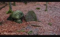
The stone, 2.7m high, carries an incised figure of a naked warrior. Armed with a large rectangular shield and a long spear with a leaf-shaped blade, he marches from right to left across the top third of the monolith. Two other faint symbols, tentatively identified as an arch and a Pictish beast, have been found on the left-hand edge, level with the warrior's chest.
Aerial photography of the field has identified traces of a series of barrow mounds, and the monolith is likely to be a prehistoric standing stone. The stone fell over in 1994, but has since been re-erected and fixed into place. When visited, the farmer was more than happy to point me over the fields to the stone. He reckoned that in his youth the carving was more obvious than it appears today. He said that large numbers of visitors still appear to see the stone, and he was certainly more than happy to advise me how to get there. Be warned, however - this involves climbing over barbed wire and electrified fences, and jumping over a ditch! Well worth it, however!
You may be viewing yesterday's version of this page. To see the most up to date information please register for a free account.
")
")
")
")
")
")
Do not use the above information on other web sites or publications without permission of the contributor.
Click here to see more info for this site
Nearby sites
Key: Red: member's photo, Blue: 3rd party photo, Yellow: other image, Green: no photo - please go there and take one, Grey: site destroyed
Download sites to:
KML (Google Earth)
GPX (GPS waypoints)
CSV (Garmin/Navman)
CSV (Excel)
To unlock full downloads you need to sign up as a Contributory Member. Otherwise downloads are limited to 50 sites.
Turn off the page maps and other distractions
Nearby sites listing. In the following links * = Image available
100m W 269° Newton of Collessie Class I Pictish Symbol Stone (NO292132)
4.6km NW 312° Lindores* Class I Pictish Symbol Stone (NO25951634)
5.6km ESE 108° Walton Symbol Stone Class I Pictish Symbol Stone (NO34651135)
6.9km WSW 245° Auchtermuchty Cursus Cursus (NO22951043)
7.1km SSW 214° Westfield Farm Class I Pictish Symbol Stone (NO25260735)
7.5km WNW 297° Macduff's Cross* Early Christian Sculptured Stone (NO227167)
7.7km NW 308° Laing's Museum, Newburgh* Museum (NO233181)
8.2km WSW 248° Strathmiglo* Class I Pictish Symbol Stone (NO2166810219)
8.2km NNE 17° Creich Manse* Class I Pictish Symbol Stone (NO319210)
8.4km NW 305° Mugdrum Class III Pictish Cross Slab (NO22531819)
8.5km SW 214° East Lomond Hill Hillfort (NO24400620)
8.9km SW 230° Kilgour Class I Pictish Symbol Stone (NO223076)
10.1km S 184° Balfarg Riding School mortuary enclosure and henge* Henge (NO28480314)
10.1km S 185° Balfarg Henge* Henge (NO2819803123)
10.2km S 183° Balbirnie* Stone Circle (NO2858702969)
10.8km WNW 286° Abernethy Symbol Stone* Class I Pictish Symbol Stone (NO18991638)
10.8km NW 318° Grey Stone (St Madoes)* Standing Stone (Menhir) (NO22172131)
10.8km E 99° Spout Well* Holy Well or Sacred Spring (NO400114)
10.9km WNW 285° Abernethy Den* Stone Circle (NO188161)
11.0km WNW 288° Abernethy Circle Stone Circle (NO189168)
11.2km NE 49° Lochmaloney Farmm (Kilmany) Rock Art (NO37902049)
12.3km NW 308° St Madoes Stones* Stone Row / Alignment (NO197210)
12.9km SE 139° Aithernie (Scoonie) Cairn (NO37690339)
13.0km ESE 116° Norrie's Law* Round Barrow(s) (NO409073)
13.1km SE 141° Balgrummo* Standing Stone (Menhir) (NO375029)
View more nearby sites and additional images


 We would like to know more about this location. Please feel free to add a brief description and any relevant information in your own language.
 Wir möchten mehr über diese Stätte erfahren. Bitte zögern Sie nicht, eine kurze Beschreibung und relevante Informationen in Deutsch hinzuzufügen.
 Nous aimerions en savoir encore un peu sur les lieux. S'il vous plaît n'hesitez pas à ajouter une courte description et tous les renseignements pertinents dans votre propre langue.
 Quisieramos informarnos un poco más de las lugares. No dude en añadir una breve descripción y otros datos relevantes en su propio idioma.