<< Our Photo Pages >> Ravenswood Avenue - Standing Stone (Menhir) in Scotland in Midlothian
Submitted by crannog on Wednesday, 03 March 2004 Page Views: 16216
Neolithic and Bronze AgeSite Name: Ravenswood Avenue Alternative Name: CraigendCountry: Scotland County: Midlothian Type: Standing Stone (Menhir)
Nearest Town: Edinburgh Nearest Village: Ravenswood Avenue
Map Ref: NT2828270502 Landranger Map Number: 66
Latitude: 55.922229N Longitude: 3.149186W
Condition:
| 5 | Perfect |
| 4 | Almost Perfect |
| 3 | Reasonable but with some damage |
| 2 | Ruined but still recognisable as an ancient site |
| 1 | Pretty much destroyed, possibly visible as crop marks |
| 0 | No data. |
| -1 | Completely destroyed |
| 5 | Superb |
| 4 | Good |
| 3 | Ordinary |
| 2 | Not Good |
| 1 | Awful |
| 0 | No data. |
| 5 | Can be driven to, probably with disabled access |
| 4 | Short walk on a footpath |
| 3 | Requiring a bit more of a walk |
| 2 | A long walk |
| 1 | In the middle of nowhere, a nightmare to find |
| 0 | No data. |
| 5 | co-ordinates taken by GPS or official recorded co-ordinates |
| 4 | co-ordinates scaled from a detailed map |
| 3 | co-ordinates scaled from a bad map |
| 2 | co-ordinates of the nearest village |
| 1 | co-ordinates of the nearest town |
| 0 | no data |
Internal Links:
External Links:
I have visited· I would like to visit
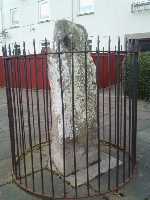
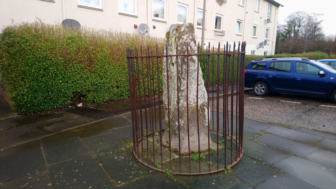
Enki visited on 11th Aug 2019 - their rating: Cond: 3 Amb: 3 Access: 5 A pleasant walk through the housing estate (after visiting the Cat Stane at Inch) brought us to this sad menhir, cut off from its surroundings by an enclosing metal cage. Again, not in its original position, although I was able to dowse the likely location of that in the road.
The metal railings effectively cut off any decent energy lines; I was only able to dowse one line running through it diagonally.
Anne T visited on 20th Feb 2017 - their rating: Cond: 3 Amb: 2 Access: 4 Ravenswood Avenue Standing Stone, Edinburgh: Our third stop of the day, and another ‘not impressive’ one. Definitely not in situ, at the end of a heavily parked-up cul-de-sac, outside a small block of flat, protected by a tall circular iron railing.
I was glad to escape from this site – it felt very depressing and I surprised not to see any graffiti on the stone. One source I’d seen said there were a couple of cup marks, but I could only see any, only natural weathering and what looked like a heavily worn quarry mark.
Andy B: would like to visit No 4. in Kenny Brophy's Top Ten Urban Prehistory site selections, compiled for our Old Stones book.
Average ratings for this site from all visit loggers: Condition: 3 Ambience: 2.5 Access: 4.5

The stone is recorded as Canmore ID 52108 which tells us: "This standing stone is 6' 3/4' high and it has a girth of 6'5" at 3' from the base. Its main axis is almost due N-S, but with a slight inclination towards the E. It is of grey sandstone, badly weathered on two sides, and without any artificial markings ..... This stone is not quite in situ. It was moved a few yards from its original position (in the present roadway) and set in concrete, protected by a railing, during the construction of the housing scheme in the vicinity."
You may be viewing yesterday's version of this page. To see the most up to date information please register for a free account.


Do not use the above information on other web sites or publications without permission of the contributor.
Click here to see more info for this site
Nearby sites
Key: Red: member's photo, Blue: 3rd party photo, Yellow: other image, Green: no photo - please go there and take one, Grey: site destroyed
Download sites to:
KML (Google Earth)
GPX (GPS waypoints)
CSV (Garmin/Navman)
CSV (Excel)
To unlock full downloads you need to sign up as a Contributory Member. Otherwise downloads are limited to 50 sites.
Turn off the page maps and other distractions
Nearby sites listing. In the following links * = Image available
848m W 281° Cat Stane (Inch)* Standing Stone (Menhir) (NT27457068)
1.8km ENE 64° Niddrie House* Standing Stone (Menhir) (NT29877125)
2.2km NNW 336° Samson's Ribs* Promontory Fort / Cliff Castle (NT27457250)
2.2km N 357° Delf Well* Holy Well or Sacred Spring (NT282727)
2.3km WNW 303° Penny Well (Edinburgh)* Holy Well or Sacred Spring (NT26367177)
2.3km SSW 203° Balm Well* Holy Well or Sacred Spring (NT2732268363)
2.4km NNW 344° Arthur's Seat* Hillfort (NT27647282)
2.6km N 359° Holyrood Park Stone (Edinburgh) Natural Stone / Erratic / Other Natural Feature (NT28267313)
2.7km N 357° Dunsapie Crag* Hillfort (NT28177316)
2.7km NW 325° Slidey Stane (Holyrood Park)* Natural Stone / Erratic / Other Natural Feature (NT2676672765)
2.9km NNW 343° The Dasses* Ancient Village or Settlement (NT27477326)
2.9km W 271° Blackford Hill* Rock Art (NT2537270603)
3.0km NNW 334° Salisbury Crags* Promontory Fort / Cliff Castle (NT27007326)
3.2km NNW 345° St Anthony's Well (Edinburgh)* Holy Well or Sacred Spring (NT27527364)
3.3km NW 316° Edinburgh Runestone* Carving (NT2598972937)
3.4km NNW 339° St Margaret's Well (Edinburgh)* Holy Well or Sacred Spring (NT2713373712)
3.6km SW 232° Galachlaw Cairn* Cairn (NT25366831)
3.7km NW 318° National Museum of Scotland (Early Christian Stones)* Ancient Cross (NT2583273324)
3.7km NNW 335° Girth Cross (Canongate)* Ancient Cross (NT2673973910)
3.8km NW 317° National Museum of Scotland* Museum (NT2574873290)
3.8km W 271° Hanging Stanes (Braid Road)* Marker Stone (NT24517061)
3.8km NNW 330° Canongate Mercat Cross* Ancient Cross (NT2647273812)
3.8km NW 317° National Museum of Scotland (Pictish Stones)* Museum (NT2572173302)
3.8km NNW 327° St John's Cross (Canongate)* Ancient Cross (NT2628873733)
3.9km WNW 285° The Bore Stone* Marker Stone (NT2450871568)
View more nearby sites and additional images


 We would like to know more about this location. Please feel free to add a brief description and any relevant information in your own language.
 Wir möchten mehr über diese Stätte erfahren. Bitte zögern Sie nicht, eine kurze Beschreibung und relevante Informationen in Deutsch hinzuzufügen.
 Nous aimerions en savoir encore un peu sur les lieux. S'il vous plaît n'hesitez pas à ajouter une courte description et tous les renseignements pertinents dans votre propre langue.
 Quisieramos informarnos un poco más de las lugares. No dude en añadir una breve descripción y otros datos relevantes en su propio idioma.