<< Our Photo Pages >> The Priapus Stone - Standing Stone (Menhir) in England in Cumbria
Submitted by Sunny100 on Sunday, 30 May 2010 Page Views: 12817
Neolithic and Bronze AgeSite Name: The Priapus Stone Alternative Name: The Great Urswick Stone, The Fertility StoneCountry: England County: Cumbria Type: Standing Stone (Menhir)
Nearest Town: Ulverston Nearest Village: Great Urswick
Map Ref: SD26757415
Latitude: 54.157914N Longitude: 3.123211W
Condition:
| 5 | Perfect |
| 4 | Almost Perfect |
| 3 | Reasonable but with some damage |
| 2 | Ruined but still recognisable as an ancient site |
| 1 | Pretty much destroyed, possibly visible as crop marks |
| 0 | No data. |
| -1 | Completely destroyed |
| 5 | Superb |
| 4 | Good |
| 3 | Ordinary |
| 2 | Not Good |
| 1 | Awful |
| 0 | No data. |
| 5 | Can be driven to, probably with disabled access |
| 4 | Short walk on a footpath |
| 3 | Requiring a bit more of a walk |
| 2 | A long walk |
| 1 | In the middle of nowhere, a nightmare to find |
| 0 | No data. |
| 5 | co-ordinates taken by GPS or official recorded co-ordinates |
| 4 | co-ordinates scaled from a detailed map |
| 3 | co-ordinates scaled from a bad map |
| 2 | co-ordinates of the nearest village |
| 1 | co-ordinates of the nearest town |
| 0 | no data |
Internal Links:
External Links:
I have visited· I would like to visit
SumDoood would like to visit
rvbaker2003 visited on 29th Dec 2024 - their rating: Cond: 2 Amb: 2 Access: 5
")
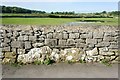
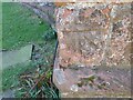
Up until 1920 the stone had stood up-right in the field close by, but it was built into the wall in order that less damage might occur. It is a somewhat crude phalic symbol that was, long ago, used in ancient fertility rites. The people of Urswick used to decorate the stone to look like Priapus, the ancient god of fertility and son of Aphrodite. The ancient Greeks and Romans honoured him with temples and wall paintings.
On Midsummer's Day coloured rags were smeared with butter or sheep's saliva, and the head decorated with flowers. All this in the hope that a 'fruitful procreation would be stimulated'. Thankfully all this died out in the early 1900s. Although some might not agree with the "thanfully" bit. The age of this stone is uncertain, but it probably dates back to the Dark Ages and even further back than that.
The stone is recorded as Pastscape Monument No. 38184, and is also included in the Old Cumbria Gazetteer's entry for the Priapus Stone. The Journal of Antiquities also includes an entry for this stone - see their page for The Priapus Stone, Great Urswick, Cumbria.
You may be viewing yesterday's version of this page. To see the most up to date information please register for a free account.
")
")
")
")
Do not use the above information on other web sites or publications without permission of the contributor.
Nearby Images from Geograph Britain and Ireland:

©2024(licence)
©2012(licence)
©2007(licence)
©2022(licence)

©2022(licence)
The above images may not be of the site on this page, they are loaded from Geograph.
Please Submit an Image of this site or go out and take one for us!
Click here to see more info for this site
Nearby sites
Key: Red: member's photo, Blue: 3rd party photo, Yellow: other image, Green: no photo - please go there and take one, Grey: site destroyed
Download sites to:
KML (Google Earth)
GPX (GPS waypoints)
CSV (Garmin/Navman)
CSV (Excel)
To unlock full downloads you need to sign up as a Contributory Member. Otherwise downloads are limited to 50 sites.
Turn off the page maps and other distractions
Nearby sites listing. In the following links * = Image available
130m ENE 57° Great Urswick Cross* Ancient Cross (SD26867422)
549m WNW 299° Great Urswick Burial Chamber* Burial Chamber or Dolmen (SD26277442)
749m W 265° Urswick Stone Walls* Ancient Village or Settlement (SD260741)
1.1km NNE 33° Great Urswick Fort* Hillfort (SD274751)
1.4km NNE 27° Great Urswick Long Barrow* Long Barrow (SD27427540)
1.5km E 95° Birkrigg Common Platform Cairn* Cairn (SD282740)
1.5km WNW 300° Lindal Standing Stone* Standing Stone (Menhir) (SD255749)
1.8km E 81° Birkrigg Common Round Cairn 1 Round Cairn (SD285744)
1.9km E 87° Birkrigg Common Cemetery* Barrow Cemetery (SD28627421)
2.1km E 79° Birkrigg Common Enclosures and Appleby Hill and Stone Circle Ancient Village or Settlement (SD288745)
2.1km ENE 77° Birkrigg Common Round Cairn 3 Round Cairn (SD288746)
2.1km ENE 79° Birkrigg Common Settlement* Ancient Village or Settlement (SD28837453)
2.1km E 85° Birkrigg Common Round Cairn 2* Round Cairn (SD289743)
2.5km E 93° Druids Temple (Cumbria)* Stone Circle (SD29237396)
3.5km SSW 196° St Michael's Well (Gleaston) Holy Well or Sacred Spring (SD2572070820)
5.3km WNW 285° St Helen's Well (Askam and Ireleth) Holy Well or Sacred Spring (SD2161075640)
5.5km NNE 28° Hoad Hill* Cairn (SD294790)
8.7km NNW 348° The Kirk Ring Cairn* Stone Circle (SD2507082693)
8.8km NNW 348° The Kirk Stone Row* Multiple Stone Rows / Avenue (SD2509182770)
9.0km N 349° Kirkby Moor Ringcairn* Round Cairn (SD25148299)
9.3km NNE 30° Sheriff's Well (Greenodd) Holy Well or Sacred Spring (SD3150082130)
9.7km ENE 70° Holker Labyrinth and Standing Stones Modern Stone Circle etc (SD3590677373)
9.8km NNE 28° Greenodd Holy Well (Egton with Newland) Holy Well or Sacred Spring (SD3144082770)
9.9km NNW 340° Kirkby Hall Holy Well (Kirkby Ireleth) Holy Well or Sacred Spring (SD2357083550)
10.1km N 6° The Beacon (Cumbria)* Stone Circle (SD28008423)
View more nearby sites and additional images


 We would like to know more about this location. Please feel free to add a brief description and any relevant information in your own language.
 Wir möchten mehr über diese Stätte erfahren. Bitte zögern Sie nicht, eine kurze Beschreibung und relevante Informationen in Deutsch hinzuzufügen.
 Nous aimerions en savoir encore un peu sur les lieux. S'il vous plaît n'hesitez pas à ajouter une courte description et tous les renseignements pertinents dans votre propre langue.
 Quisieramos informarnos un poco más de las lugares. No dude en añadir una breve descripción y otros datos relevantes en su propio idioma.