

<< Our Photo Pages >> King Shaw's Grave - Cairn in Scotland in Dumfries and Galloway
Submitted by coldrum on Thursday, 21 June 2007 Page Views: 7748
Neolithic and Bronze AgeSite Name: King Shaw's Grave Alternative Name: King Schaw's Grave; Bank Head Hill; King Schaw's CistCountry: Scotland County: Dumfries and Galloway Type: Cairn
Nearest Town: Langholm
Map Ref: NY25939320
Latitude: 55.227437N Longitude: 3.166046W
Condition:
| 5 | Perfect |
| 4 | Almost Perfect |
| 3 | Reasonable but with some damage |
| 2 | Ruined but still recognisable as an ancient site |
| 1 | Pretty much destroyed, possibly visible as crop marks |
| 0 | No data. |
| -1 | Completely destroyed |
| 5 | Superb |
| 4 | Good |
| 3 | Ordinary |
| 2 | Not Good |
| 1 | Awful |
| 0 | No data. |
| 5 | Can be driven to, probably with disabled access |
| 4 | Short walk on a footpath |
| 3 | Requiring a bit more of a walk |
| 2 | A long walk |
| 1 | In the middle of nowhere, a nightmare to find |
| 0 | No data. |
| 5 | co-ordinates taken by GPS or official recorded co-ordinates |
| 4 | co-ordinates scaled from a detailed map |
| 3 | co-ordinates scaled from a bad map |
| 2 | co-ordinates of the nearest village |
| 1 | co-ordinates of the nearest town |
| 0 | no data |
Be the first person to rate this site - see the 'Contribute!' box in the right hand menu.
Internal Links:
External Links:
")
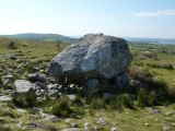
The cist all that remains of a cairn removed in 1828.
Eskdale, Dumfrishire, Scotland.
For more information see Canmore ID 67325 which says this cist is: "Situated on a slight eminence in fairly level moorland, now afforested, the site clearly once commanded extensive views, especially down the Esk valley, but trees now obscure visibility. The remains now comprise a low mound of stones which has been almost entirely removed, but has an identifiable diameter of 15.5m. In the centre there is a well-constructed cist of rectangular slabs orientated NW-SE and measuring 1.25m by 0.6m by 0.75m high. It is built of three slabs (the SW end being now open) and is covered by a well-fitting capstone." They add that this was clearly a complex site with as many as five cists.
You may be viewing yesterday's version of this page. To see the most up to date information please register for a free account.
")
")
")
")
")
")
Do not use the above information on other web sites or publications without permission of the contributor.
Click here to see more info for this site
Nearby sites
Key: Red: member's photo, Blue: 3rd party photo, Yellow: other image, Green: no photo - please go there and take one, Grey: site destroyed
Download sites to:
KML (Google Earth)
GPX (GPS waypoints)
CSV (Garmin/Navman)
CSV (Excel)
To unlock full downloads you need to sign up as a Contributory Member. Otherwise downloads are limited to 50 sites.
Turn off the page maps and other distractions
Nearby sites listing. In the following links * = Image available
710m SE 127° Bank Head Hill Ancient Village or Settlement (NY2648992760)
1.4km SE 133° Green Hill (Lyneholm)* Misc. Earthwork (NY26939223)
1.4km W 280° Over Rig* Misc. Earthwork (NY2455693475)
1.5km SW 229° The Knowe* Ancient Village or Settlement (NY24799226)
1.8km WSW 258° Castle O'er Fort* Hillfort (NY2419092850)
2.2km SE 140° White Birren* Hillfort (NY27329148)
2.5km NNW 335° Bessie's Hill Settlement Ancient Village or Settlement (NY249955)
2.6km NNW 335° Bessie's Hill Fort* Hillfort (NY2490095540)
2.7km S 186° Bailiehill Fort* Hillfort (NY2558090520)
3.0km NNW 348° Girdle Stanes* Stone Circle (NY2535196153)
3.4km N 356° Loupin' Stanes SE* Stone Row / Alignment (NY25729660)
3.4km N 355° Loupin' Stanes NW* Stone Circle (NY25709663)
3.8km ESE 120° Bogle Walls* Hillfort (NY29249124)
5.5km SE 125° Boonies Ancient Village or Settlement (NY304900)
5.9km SW 217° Kirkslight Rig Stone Circle (NY223885)
6.0km ESE 121° Westerkirk Stone Circle (NY3190)
6.2km SSW 213° Whitcastles* Stone Circle (NY22408806)
6.6km SE 136° Shaw Hill (Westerkirk) Hillfort (NY30458834)
7.0km NNW 348° Naga Stupa(cairn)* Modern Stone Circle etc (NT246001)
9.3km ESE 122° Little Hill (Craig)* Hillfort (NY3383088160)
9.7km SSW 192° Newhall Hill (Paddockhole)* Ancient Village or Settlement (NY23808372)
10.8km ESE 119° Barntalloch (Langholm)* Misc. Earthwork (NY35258776)
11.3km SSW 201° Whiteholme Rig* Stone Circle (NY21718269)
12.2km WNW 282° Kirkhill* Stone Circle (NY1397895929)
13.2km WNW 283° St Cuthbert's Church (Wamphray)* Ancient Cross (NY1307096462)
View more nearby sites and additional images


 We would like to know more about this location. Please feel free to add a brief description and any relevant information in your own language.
 Wir möchten mehr über diese Stätte erfahren. Bitte zögern Sie nicht, eine kurze Beschreibung und relevante Informationen in Deutsch hinzuzufügen.
 Nous aimerions en savoir encore un peu sur les lieux. S'il vous plaît n'hesitez pas à ajouter une courte description et tous les renseignements pertinents dans votre propre langue.
 Quisieramos informarnos un poco más de las lugares. No dude en añadir una breve descripción y otros datos relevantes en su propio idioma.