


<< Other Photo Pages >> Cademuir Hill - Hillfort in Scotland in Scottish Borders
Submitted by Andy B on Saturday, 20 March 2021 Page Views: 1674
EnglandSite Name: Cademuir HillCountry: Scotland County: Scottish Borders Type: Hillfort
Map Ref: NT22473708
Latitude: 55.621099N Longitude: 3.232651W
Condition:
| 5 | Perfect |
| 4 | Almost Perfect |
| 3 | Reasonable but with some damage |
| 2 | Ruined but still recognisable as an ancient site |
| 1 | Pretty much destroyed, possibly visible as crop marks |
| 0 | No data. |
| -1 | Completely destroyed |
| 5 | Superb |
| 4 | Good |
| 3 | Ordinary |
| 2 | Not Good |
| 1 | Awful |
| 0 | No data. |
| 5 | Can be driven to, probably with disabled access |
| 4 | Short walk on a footpath |
| 3 | Requiring a bit more of a walk |
| 2 | A long walk |
| 1 | In the middle of nowhere, a nightmare to find |
| 0 | No data. |
| 5 | co-ordinates taken by GPS or official recorded co-ordinates |
| 4 | co-ordinates scaled from a detailed map |
| 3 | co-ordinates scaled from a bad map |
| 2 | co-ordinates of the nearest village |
| 1 | co-ordinates of the nearest town |
| 0 | no data |
Internal Links:
External Links:
")
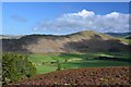
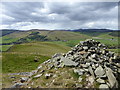
The fort is situated at a height of 1050' OD on a rocky knoll at the SW end of the elongated summit of Cademuir Hill. It is a little under half a mile SW of No.263, and 250' below it. A very steep slope affords the site great natural protection on the SE, but the ground is only moderately inclined on the SW and NW, while the approach from the NE is over level ground.
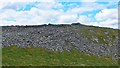
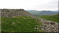
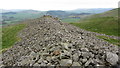
The fort measures 240' by 120' within a stone wall (A), the debris of which has formed great scree-like deposits on the flanks of the knoll. Stretches of both faces are still visible in situ on the E and indicate that on this side the wall originally measured about 20' in thickness: on the other sides, where the flanks of the knoll provide some protection, it was probably substantially narrower.
Source: Canmore
You may be viewing yesterday's version of this page. To see the most up to date information please register for a free account.
")
")
")
Do not use the above information on other web sites or publications without permission of the contributor.
Nearby Images from Geograph Britain and Ireland:
©2018(licence)
©2018(licence)
©2014(licence)
©2014(licence)
©2017(licence)
The above images may not be of the site on this page, they are loaded from Geograph.
Please Submit an Image of this site or go out and take one for us!
Click here to see more info for this site
Nearby sites
Key: Red: member's photo, Blue: 3rd party photo, Yellow: other image, Green: no photo - please go there and take one, Grey: site destroyed
Download sites to:
KML (Google Earth)
GPX (GPS waypoints)
CSV (Garmin/Navman)
CSV (Excel)
To unlock full downloads you need to sign up as a Contributory Member. Otherwise downloads are limited to 50 sites.
Turn off the page maps and other distractions
Nearby sites listing. In the following links * = Image available
1.6km N 7° Kirkton Manor* Standing Stone (Menhir) (NT22693863)
3.8km NW 320° Sheriff Muir Standing Stones* Standing Stones (NT20094005)
3.9km NNW 328° Meldon Bridge Timber Circle (NT205404)
4.2km W 277° Stobo Kirk standing stone* Standing Stone (Menhir) (NT1826037655)
4.6km NE 42° Whitestone (Peebles)* Marker Stone (NT256404)
5.8km N 353° White Meldon* Round Cairn (NT21894284)
5.9km NNW 349° Druids Circle (Eddleston)* Henge (NT21404290)
6.5km N 349° Green Knowe Round Cairn (NT21384351)
6.5km NE 42° Soonhope Rock Art Rock Art (NT269419)
6.9km WSW 258° Altar Stone, Stobo* Standing Stone (Menhir) (NT15703573)
7.7km ENE 75° Cardrona* Standing Stone (Menhir) (NT30003895)
7.9km NNE 32° Soonhope cairn* Chambered Cairn (NT268437)
8.0km NNW 338° Harehope Rings* Hillfort (NT1962644573)
8.7km WSW 258° Drumelzier Haugh* Standing Stone (Menhir) (NT13933542)
8.7km WSW 251° Tinnis Castle* Hillfort (NT14153444)
8.9km SSW 205° Nethertown Stone Circle (NT185291)
9.0km SSW 196° Manorhead Standing Stone (Menhir) (NT19862850)
9.4km SSE 151° Bught Rig Standing Stones (NT26852876)
9.6km SSE 149° Douglas Water SE Stone Circle (NT273288)
9.6km SSE 149° Douglas Water NW* Stone Circle (NT273288)
9.6km W 260° Dreva Hill West (Broughton)* Ancient Village or Settlement (NT12923553)
9.9km W 259° Dreva Craig* Hillfort (NT12673533)
10.1km W 260° Dreva Craig* Standing Stone (Menhir) (NT12453545)
11.3km WSW 253° Piper's Stone Standing Stone (Menhir) (NT11533400)
11.5km WSW 252° Rachan Hill Henge (NT11423363)
View more nearby sites and additional images


 We would like to know more about this location. Please feel free to add a brief description and any relevant information in your own language.
 Wir möchten mehr über diese Stätte erfahren. Bitte zögern Sie nicht, eine kurze Beschreibung und relevante Informationen in Deutsch hinzuzufügen.
 Nous aimerions en savoir encore un peu sur les lieux. S'il vous plaît n'hesitez pas à ajouter une courte description et tous les renseignements pertinents dans votre propre langue.
 Quisieramos informarnos un poco más de las lugares. No dude en añadir una breve descripción y otros datos relevantes en su propio idioma.