

, Aubrey Burl")
<< Our Photo Pages >> Pen Cerrig-calch - Cairn in Wales in Powys
Submitted by pab on Wednesday, 11 April 2007 Page Views: 6923
Neolithic and Bronze AgeSite Name: Pen Cerrig-calchCountry: Wales
NOTE: This site is 2.2 km away from the location you searched for.
County: Powys Type: Cairn
Nearest Town: Abergavenney Nearest Village: Crickhowell
Map Ref: SO21702236
Latitude: 51.894268N Longitude: 3.139271W
Condition:
| 5 | Perfect |
| 4 | Almost Perfect |
| 3 | Reasonable but with some damage |
| 2 | Ruined but still recognisable as an ancient site |
| 1 | Pretty much destroyed, possibly visible as crop marks |
| 0 | No data. |
| -1 | Completely destroyed |
| 5 | Superb |
| 4 | Good |
| 3 | Ordinary |
| 2 | Not Good |
| 1 | Awful |
| 0 | No data. |
| 5 | Can be driven to, probably with disabled access |
| 4 | Short walk on a footpath |
| 3 | Requiring a bit more of a walk |
| 2 | A long walk |
| 1 | In the middle of nowhere, a nightmare to find |
| 0 | No data. |
| 5 | co-ordinates taken by GPS or official recorded co-ordinates |
| 4 | co-ordinates scaled from a detailed map |
| 3 | co-ordinates scaled from a bad map |
| 2 | co-ordinates of the nearest village |
| 1 | co-ordinates of the nearest town |
| 0 | no data |
Internal Links:
External Links:
I have visited· I would like to visit
SolarMegalith would like to visit
lboutside visited - their rating: Cond: 2 Amb: 3 Access: 2
PAB eyesopen have visited here
")
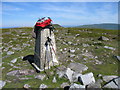
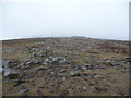
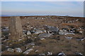
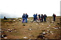
Both Cairns have been significantly damaged by their centres being hollowed out to create more effective sheep shelters, but they are still formidable structures.
The RCAHMW describes them as:
Cairn 1 (SO21752223) - A centrally disturbed cairn, 16.5m in diameter and 1.1-2.5m high
Cairn 2 (SO21652241) - A cairn upon the summit of Pen Cerrig-calch, 15.4m in diameter and 1.3m high, centrally mutilated by a sheep shelter.
When visiting the site Easter 2007, I also noticed a combination of stones which did not seem totally natural, perhaps being the remains of a capstone over a chambered structure. It stood out to me among the limestone slabs which give this hill its name, but I would not want to be too dogmatic about it....hopefully someone with a keener eye and experience will have the chance to look closer - approximately SO21772223 from the map.
You may be viewing yesterday's version of this page. To see the most up to date information please register for a free account.
")
")
")
")
Do not use the above information on other web sites or publications without permission of the contributor.
Nearby Images from Geograph Britain and Ireland:
©2013(licence)
©2012(licence)
©2008(licence)
©2011(licence)
©2015(licence)
The above images may not be of the site on this page, they are loaded from Geograph.
Please Submit an Image of this site or go out and take one for us!
Click here to see more info for this site
Nearby sites
Key: Red: member's photo, Blue: 3rd party photo, Yellow: other image, Green: no photo - please go there and take one, Grey: site destroyed
Download sites to:
KML (Google Earth)
GPX (GPS waypoints)
CSV (Garmin/Navman)
CSV (Excel)
To unlock full downloads you need to sign up as a Contributory Member. Otherwise downloads are limited to 50 sites.
Turn off the page maps and other distractions
Nearby sites listing. In the following links * = Image available
1.6km SW 223° Craig Llwyn* Ancient Village or Settlement (SO206212)
1.7km WNW 299° Pen Gloch Y Pibwr* Cairn (SO2020123205)
1.9km SSE 151° Crug Hywel* Hillfort (SO226207)
2.2km NNW 332° Pen Alltmawr Cairns* Cairn (SO2069024330)
3.2km S 190° Gwernvale* Chambered Tomb (SO2111119217)
3.7km W 262° Tretower* Standing Stone (Menhir) (SO180219)
3.9km SSE 163° Llangenny Camp* Hillfort (SO228186)
3.9km S 172° Great Oak Stone* Standing Stone (Menhir) (SO22181846)
3.9km WNW 291° Llanfihangel Cwmdu* Ancient Cross (SO18052384)
3.9km SSW 195° Llan-Wysg Well* Holy Well or Sacred Spring (SO2060318584)
4.1km SSE 150° Coed Ynys Faen* Standing Stones (SO237188)
4.2km SW 233° Penmyarth* Standing Stone (Menhir) (SO18291986)
4.4km NE 44° Nant Yr Ychen Round Cairn* Cairn (SO2476025470)
4.4km ENE 75° Disgwylfa, Cairn I* Cairn (SO2597023440)
4.4km WNW 291° Coed y Gaer Hillfort (SO176240)
4.5km SSW 207° Ffawyddog Gaer Hillfort (SO196184)
4.5km S 187° Llangattock Cross* Ancient Cross (SO2110017870)
4.6km WNW 295° Coed y Gaer Cairn Cairn (SO1759324348)
4.6km WSW 248° Myarth Camp Hillfort (SO174207)
4.7km S 185° Garn Coch (Powys)* Chambered Tomb (SO2123617708)
4.8km W 261° Celtic Head, Middle Gaer Carving (SO16962172)
5.1km SSE 153° Golden Grove* Standing Stone (Menhir) (SO2396217829)
5.3km WNW 286° Cwmdu Stone Circle (SO166239)
5.3km N 9° Maen Llwyd (Powys)* Standing Stone (Menhir) (SO22602762)
5.7km SSE 163° Cwrt-y-Gollen* Standing Stone (Menhir) (SO2324116860)
View more nearby sites and additional images


 We would like to know more about this location. Please feel free to add a brief description and any relevant information in your own language.
 Wir möchten mehr über diese Stätte erfahren. Bitte zögern Sie nicht, eine kurze Beschreibung und relevante Informationen in Deutsch hinzuzufügen.
 Nous aimerions en savoir encore un peu sur les lieux. S'il vous plaît n'hesitez pas à ajouter une courte description et tous les renseignements pertinents dans votre propre langue.
 Quisieramos informarnos un poco más de las lugares. No dude en añadir una breve descripción y otros datos relevantes en su propio idioma.