<< Other Photo Pages >> The Stone Lud - Standing Stone (Menhir) in Scotland in Caithness
Submitted by coldrum on Thursday, 06 September 2012 Page Views: 4890
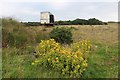
Neolithic and Bronze AgeSite Name: The Stone LudCountry: Scotland County: Caithness Type: Standing Stone (Menhir)
Map Ref: ND222617
Latitude: 58.536420N Longitude: 3.337975W
Condition:
| 5 | Perfect |
| 4 | Almost Perfect |
| 3 | Reasonable but with some damage |
| 2 | Ruined but still recognisable as an ancient site |
| 1 | Pretty much destroyed, possibly visible as crop marks |
| 0 | No data. |
| -1 | Completely destroyed |
| 5 | Superb |
| 4 | Good |
| 3 | Ordinary |
| 2 | Not Good |
| 1 | Awful |
| 0 | No data. |
| 5 | Can be driven to, probably with disabled access |
| 4 | Short walk on a footpath |
| 3 | Requiring a bit more of a walk |
| 2 | A long walk |
| 1 | In the middle of nowhere, a nightmare to find |
| 0 | No data. |
| 5 | co-ordinates taken by GPS or official recorded co-ordinates |
| 4 | co-ordinates scaled from a detailed map |
| 3 | co-ordinates scaled from a bad map |
| 2 | co-ordinates of the nearest village |
| 1 | co-ordinates of the nearest town |
| 0 | no data |
Be the first person to rate this site - see the 'Contribute!' box in the right hand menu.
Internal Links:
External Links:
")
From Clas Merdin: Tales from the Enchanted Island:
"Stone Lud
In the parish of Bower in Caithness, in the Highland region of Scotland, about four miles south of Castletown (Grid Ref: ND222617) is a standing stone known as The Stone Lud.
It is claimed that this stone marks of the grave of Ljot, (or Loitus) the 10th century earl of Caithness and Norse Orkney, who died in battle here. The name of Ljot is clearly very close to that of Lot or Loth, the mythic king of Lothian of Arthurian legend who according to Geoffrey of Monmouth was also King of Orkney.
This standing stone is about 3 metres high, significantly taller than most Norse 10th century stones and is more likely to be a much older megalith that a local legend has attached to it. The Stone Lud is similar in size to the stones of the Ring of Brodgar in Orkney, and is one of a pair, its partner having now fallen lies some 30 metres away. It said that when erect the two stones would have made an alignment with the summer solstice sunset."
http://clasmerdin.blogspot.co.uk/2008_10_01_archive.html
You may be viewing yesterday's version of this page. To see the most up to date information please register for a free account.
Do not use the above information on other web sites or publications without permission of the contributor.
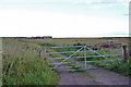
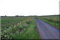
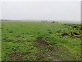
Nearby Images from Geograph Britain and Ireland:
©2010(licence)
©2010(licence)
©2022(licence)
©2010(licence)
©2017(licence)
The above images may not be of the site on this page, they are loaded from Geograph.
Please Submit an Image of this site or go out and take one for us!
Click here to see more info for this site
Nearby sites
Key: Red: member's photo, Blue: 3rd party photo, Yellow: other image, Green: no photo - please go there and take one, Grey: site destroyed
Download sites to:
KML (Google Earth)
GPX (GPS waypoints)
CSV (Garmin/Navman)
CSV (Excel)
To unlock full downloads you need to sign up as a Contributory Member. Otherwise downloads are limited to 50 sites.
Turn off the page maps and other distractions
Nearby sites listing. In the following links * = Image available
595m E 80° Mains of Bowertower Broch or Nuraghe (ND22796179)
1.8km ESE 106° Halcro Manse* Broch or Nuraghe (ND23896119)
2.7km NE 41° Ha' of Bowermadden* Broch or Nuraghe (ND23986369)
3.3km NW 304° Ha' of Durran* Broch or Nuraghe (ND19516359)
3.4km ENE 68° Murza Broch or Nuraghe (ND25386290)
4.9km S 173° Lynegar House, Oslie Cairn* Chambered Cairn (ND22715679)
5.1km SSW 200° Lower Dunn (2) Broch or Nuraghe (ND2036356940)
5.1km S 169° Lynegar House, Grey Cairn* Broch or Nuraghe (ND23045662)
5.2km WSW 259° Mill of Knockdee* Chambered Cairn (ND17036077)
5.3km SSW 200° Lower Dunn* Broch or Nuraghe (ND2026656718)
5.6km SSW 197° Bridge of Dunn Standing Stone* Standing Stone (Menhir) (ND2045156374)
5.7km E 86° Gunn's Hillock* Broch or Nuraghe (ND27926201)
5.8km NNW 345° Thurdistoft Broch or Nuraghe (ND20786731)
5.8km SE 143° Scottag* Broch or Nuraghe (ND25665699)
5.8km SSW 197° Bridge of Dunn Broch Broch or Nuraghe (ND20415613)
6.0km NNE 25° Ha' of Greenland Broch or Nuraghe (ND24906709)
6.1km WSW 254° Torran Reitheach Cairn (ND1629160143)
6.1km ESE 124° Gearsay Cairn Broch or Nuraghe (ND27265819)
6.3km SSE 158° Loch Watten Crannog* Crannog (ND24435585)
6.3km SSE 152° Tulach Gorm (Mains of Watten) Broch or Nuraghe (ND25105604)
6.4km SE 135° Coghill* Broch or Nuraghe (ND26705708)
6.5km W 271° Cnoc na Ciste Chambered Cairn (ND1572161989)
6.8km W 275° Cnoc an Tailler Cairn (ND1545462477)
6.8km W 267° Springfield Chambered Cairn Chambered Cairn (ND1533161521)
6.9km E 82° Hill of Works* Broch or Nuraghe (ND29036255)
View more nearby sites and additional images


 We would like to know more about this location. Please feel free to add a brief description and any relevant information in your own language.
 Wir möchten mehr über diese Stätte erfahren. Bitte zögern Sie nicht, eine kurze Beschreibung und relevante Informationen in Deutsch hinzuzufügen.
 Nous aimerions en savoir encore un peu sur les lieux. S'il vous plaît n'hesitez pas à ajouter une courte description et tous les renseignements pertinents dans votre propre langue.
 Quisieramos informarnos un poco más de las lugares. No dude en añadir una breve descripción y otros datos relevantes en su propio idioma.