<< Our Photo Pages >> Whimble Barrow - Round Barrow(s) in Wales in Powys
Submitted by jfarrar on Saturday, 15 June 2013 Page Views: 3763
Neolithic and Bronze AgeSite Name: Whimble BarrowCountry: Wales County: Powys Type: Round Barrow(s)
Nearest Town: New Radnor
Map Ref: SO205626
Latitude: 52.255804N Longitude: 3.166095W
Condition:
| 5 | Perfect |
| 4 | Almost Perfect |
| 3 | Reasonable but with some damage |
| 2 | Ruined but still recognisable as an ancient site |
| 1 | Pretty much destroyed, possibly visible as crop marks |
| 0 | No data. |
| -1 | Completely destroyed |
| 5 | Superb |
| 4 | Good |
| 3 | Ordinary |
| 2 | Not Good |
| 1 | Awful |
| 0 | No data. |
| 5 | Can be driven to, probably with disabled access |
| 4 | Short walk on a footpath |
| 3 | Requiring a bit more of a walk |
| 2 | A long walk |
| 1 | In the middle of nowhere, a nightmare to find |
| 0 | No data. |
| 5 | co-ordinates taken by GPS or official recorded co-ordinates |
| 4 | co-ordinates scaled from a detailed map |
| 3 | co-ordinates scaled from a bad map |
| 2 | co-ordinates of the nearest village |
| 1 | co-ordinates of the nearest town |
| 0 | no data |
Internal Links:
External Links:
")
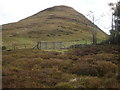
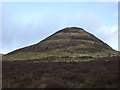
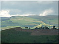
A round barrow on top of a high conical hill in the Radnor Forest. It is not accessible as it is on private land.
CPAT Record
You may be viewing yesterday's version of this page. To see the most up to date information please register for a free account.
")
")
Do not use the above information on other web sites or publications without permission of the contributor.
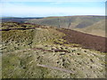
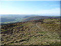
Nearby Images from Geograph Britain and Ireland:
©2008(licence)
©2012(licence)
©2012(licence)
©2012(licence)
©2012(licence)
The above images may not be of the site on this page, they are loaded from Geograph.
Please Submit an Image of this site or go out and take one for us!
Click here to see more info for this site
Nearby sites
Key: Red: member's photo, Blue: 3rd party photo, Yellow: other image, Green: no photo - please go there and take one, Grey: site destroyed
Download sites to:
KML (Google Earth)
GPX (GPS waypoints)
CSV (Garmin/Navman)
CSV (Excel)
To unlock full downloads you need to sign up as a Contributory Member. Otherwise downloads are limited to 50 sites.
Turn off the page maps and other distractions
Nearby sites listing. In the following links * = Image available
538m NNE 21° Whinyard Rocks Barrows* Round Barrow(s) (SO207631)
1.4km NE 39° Bach Hill Barrows* Round Barrow(s) (SO21396365)
1.9km NNW 331° Black Mixen Barrows* Round Barrow(s) (SO196643)
3.8km NW 307° Cwm Bwch Barrows* Round Barrow(s) (SO175649)
3.8km E 92° Crossfield Lane Barrow (Kinnerton)* Round Barrow(s) (SO24356243)
4.1km E 87° Kinnerton* Standing Stones (SO24566274)
4.4km ESE 112° Four Stones Barrow Cemetary* Barrow Cemetery (SO24596091)
4.4km ESE 113° Four Stones (Powys)* Stone Circle (SO24576080)
4.5km ESE 117° Hindwell Cursus* Cursus (SO24496052)
4.5km SE 124° Harpton Round Barrows* Round Barrow(s) (SO24225998)
4.7km ESE 110° The Hindwell Stone* Standing Stone (Menhir) (SO24916093)
4.8km ESE 105° Upper Ninepence barrow and Neolithic enclosure Round Barrow(s) (SO251613)
4.8km ESE 112° Hindwell Cursus* Cursus (SO24926074)
4.8km ESE 122° Knapp Mount Barrow* Barrow Cemetery (SO2458659975)
5.0km ESE 109° Hindwell Farm 2* Round Barrow(s) (SO25226091)
5.1km SSW 210° Llanfihangel Nant Melan* Standing Stone (Menhir) (SO1783258231)
5.2km ESE 111° Hindwell Farm 1* Round Barrow(s) (SO25376064)
5.3km ESE 110° Hindwell Enclosure* Timber Circle (SO2544560720)
5.4km ESE 105° Hindwell Ash* Round Barrow(s) (SO25706111)
5.4km ESE 118° Walton Palisaded Enclosure* Timber Circle (SO25235996)
5.7km SE 127° Old Radnor Church* Standing Stone (Menhir) (SO24995909)
5.7km WNW 298° Shepherd's Tump* Round Barrow(s) (SO155654)
5.8km ENE 73° Beggar's Bush Barrow* Round Barrow(s) (SO26096417)
5.8km SW 227° The Van* Round Barrow(s) (SO162587)
5.9km ESE 102° Knobley Stone* Standing Stone (Menhir) (SO26296132)
View more nearby sites and additional images


 We would like to know more about this location. Please feel free to add a brief description and any relevant information in your own language.
 Wir möchten mehr über diese Stätte erfahren. Bitte zögern Sie nicht, eine kurze Beschreibung und relevante Informationen in Deutsch hinzuzufügen.
 Nous aimerions en savoir encore un peu sur les lieux. S'il vous plaît n'hesitez pas à ajouter une courte description et tous les renseignements pertinents dans votre propre langue.
 Quisieramos informarnos un poco más de las lugares. No dude en añadir una breve descripción y otros datos relevantes en su propio idioma.