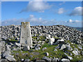
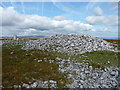
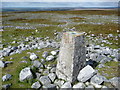
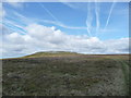
<< Our Photo Pages >> Mynydd Pen-cyrn Barrow Cemetery - Barrow Cemetery in Wales in Powys
Submitted by thehappydruid on Wednesday, 24 July 2019 Page Views: 839
Neolithic and Bronze AgeSite Name: Mynydd Pen-cyrn Barrow CemeteryCountry: Wales
NOTE: This site is 0.6 km away from the location you searched for.
County: Powys Type: Barrow Cemetery
Nearest Town: Newport Nearest Village: LLangattock
Map Ref: SO20281449
Latitude: 51.823322N Longitude: 3.158084W
Condition:
| 5 | Perfect |
| 4 | Almost Perfect |
| 3 | Reasonable but with some damage |
| 2 | Ruined but still recognisable as an ancient site |
| 1 | Pretty much destroyed, possibly visible as crop marks |
| 0 | No data. |
| -1 | Completely destroyed |
| 5 | Superb |
| 4 | Good |
| 3 | Ordinary |
| 2 | Not Good |
| 1 | Awful |
| 0 | No data. |
| 5 | Can be driven to, probably with disabled access |
| 4 | Short walk on a footpath |
| 3 | Requiring a bit more of a walk |
| 2 | A long walk |
| 1 | In the middle of nowhere, a nightmare to find |
| 0 | No data. |
| 5 | co-ordinates taken by GPS or official recorded co-ordinates |
| 4 | co-ordinates scaled from a detailed map |
| 3 | co-ordinates scaled from a bad map |
| 2 | co-ordinates of the nearest village |
| 1 | co-ordinates of the nearest town |
| 0 | no data |
Be the first person to rate this site - see the 'Contribute!' box in the right hand menu.
Internal Links:
External Links:
I have visited· I would like to visit
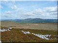
PBertson visited on 4th Jun 2023 - their rating: Cond: 3 Amb: 5 Access: 2 A superb location with views of the Black Mountains, the Eastern end of the South Wales valleys across to Merthyr and the tops of the Bannau Brycheiniog (Brecon Beacons). Best visited in a spell of dry weather as the terrain can be very boggy in places.
")
There is a possible nearby stone circle and avenue, as well as other barrows and cairns north and west of the summit.
You may be viewing yesterday's version of this page. To see the most up to date information please register for a free account.
")
Do not use the above information on other web sites or publications without permission of the contributor.
Nearby Images from Geograph Britain and Ireland:
©2006(licence)
©2013(licence)
©2013(licence)
©2013(licence)
©2013(licence)
The above images may not be of the site on this page, they are loaded from Geograph.
Please Submit an Image of this site or go out and take one for us!
Click here to see more info for this site
Nearby sites
Key: Red: member's photo, Blue: 3rd party photo, Yellow: other image, Green: no photo - please go there and take one, Grey: site destroyed
Download sites to:
KML (Google Earth)
GPX (GPS waypoints)
CSV (Garmin/Navman)
CSV (Excel)
To unlock full downloads you need to sign up as a Contributory Member. Otherwise downloads are limited to 50 sites.
Turn off the page maps and other distractions
Nearby sites listing. In the following links * = Image available
13m ENE 71° Mynydd Pen-Cyrn Stone Circle* Stone Circle (SO2029214494)
842m NNE 15° Ogof Darren Cilau Cave Cave or Rock Shelter (SO20511530)
1.1km ESE 115° Llanelly Round Barrow(s) (SO213140)
1.2km NW 319° Cairn south of Eglwys Faen* Cairn (SO1948415430)
1.5km NW 318° Eglwys Faen Cave Cave or Rock Shelter (SO19261566)
2.0km NNW 329° Coed Pentwyn* Hillfort (SO193162)
2.3km ESE 120° Craig y Gaer* Hillfort (SO223133)
2.4km ENE 69° Gaer Settlement Ancient Village or Settlement (SO225153)
3.2km WNW 287° Ty Aderyn cairn 2* Cairn (SO1724815473)
3.2km SE 127° Twyn-y-Dinas Hillfort (SO228125)
3.4km NNE 16° Garn Coch (Powys)* Chambered Tomb (SO2123617708)
3.5km NNE 13° Llangattock Cross* Ancient Cross (SO2110017870)
3.8km NE 50° Cwrt-y-Gollen* Standing Stone (Menhir) (SO2324116860)
4.0km N 349° Ffawyddog Gaer Hillfort (SO196184)
4.1km N 4° Llan-Wysg Well* Holy Well or Sacred Spring (SO2060318584)
4.3km SSE 167° Carreg Gywir Marker Stone (SO21191033)
4.3km ESE 120° Gilwern Hill* Standing Stone (Menhir) (SO2395512301)
4.4km ESE 116° Carreg Gywir* Stone Row / Alignment (SO242125)
4.4km NNE 25° Great Oak Stone* Standing Stone (Menhir) (SO22181846)
4.4km ESE 103° Bedd y Gwr Hir* Standing Stone (Menhir) (SO246134)
4.7km SE 131° Carreg Maen-Taro* Standing Stone (Menhir) (SO23831134)
4.8km N 9° Gwernvale* Chambered Tomb (SO2111119217)
4.8km NNE 31° Llangenny Camp* Hillfort (SO228186)
4.8km NW 306° Carreg Waen Llech* Standing Stone (Menhir) (SO1638717378)
5.0km NE 47° Golden Grove* Standing Stone (Menhir) (SO2396217829)
View more nearby sites and additional images


 We would like to know more about this location. Please feel free to add a brief description and any relevant information in your own language.
 Wir möchten mehr über diese Stätte erfahren. Bitte zögern Sie nicht, eine kurze Beschreibung und relevante Informationen in Deutsch hinzuzufügen.
 Nous aimerions en savoir encore un peu sur les lieux. S'il vous plaît n'hesitez pas à ajouter une courte description et tous les renseignements pertinents dans votre propre langue.
 Quisieramos informarnos un poco más de las lugares. No dude en añadir una breve descripción y otros datos relevantes en su propio idioma.