<< Our Photo Pages >> Black Mixen Barrows - Round Barrow(s) in Wales in Powys
Submitted by jfarrar on Saturday, 31 August 2013 Page Views: 4280
Neolithic and Bronze AgeSite Name: Black Mixen BarrowsCountry: Wales
NOTE: This site is 2.8 km away from the location you searched for.
County: Powys Type: Round Barrow(s)
Nearest Town: New Radnor
Map Ref: SO196643
Latitude: 52.270953N Longitude: 3.179683W
Condition:
| 5 | Perfect |
| 4 | Almost Perfect |
| 3 | Reasonable but with some damage |
| 2 | Ruined but still recognisable as an ancient site |
| 1 | Pretty much destroyed, possibly visible as crop marks |
| 0 | No data. |
| -1 | Completely destroyed |
| 5 | Superb |
| 4 | Good |
| 3 | Ordinary |
| 2 | Not Good |
| 1 | Awful |
| 0 | No data. |
| 5 | Can be driven to, probably with disabled access |
| 4 | Short walk on a footpath |
| 3 | Requiring a bit more of a walk |
| 2 | A long walk |
| 1 | In the middle of nowhere, a nightmare to find |
| 0 | No data. |
| 5 | co-ordinates taken by GPS or official recorded co-ordinates |
| 4 | co-ordinates scaled from a detailed map |
| 3 | co-ordinates scaled from a bad map |
| 2 | co-ordinates of the nearest village |
| 1 | co-ordinates of the nearest town |
| 0 | no data |
Internal Links:
External Links:
")
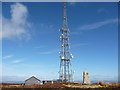
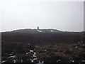
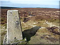
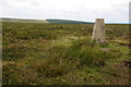
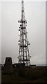
Two barrows on Black Mixen. Black Mixen I is by the transmitter. It has been damaged either by erosion or the placement of a triangulation pillar on it.
Black Mixen II is a low barrow about 1km to the north-west of the transmitter. It is in the Mynydd Ffoesidoes, a Wildlife Trust nature reserve and very difficult to approach.
To the west of Barrow II is the Cross Dyke, date unknown but assumed to be early mediaeval.
You may be viewing yesterday's version of this page. To see the most up to date information please register for a free account.
")
Do not use the above information on other web sites or publications without permission of the contributor.
Nearby Images from Geograph Britain and Ireland:
©2012(licence)
©2012(licence)
©2012(licence)
©2012(licence)
©2011(licence)
The above images may not be of the site on this page, they are loaded from Geograph.
Please Submit an Image of this site or go out and take one for us!
Click here to see more info for this site
Nearby sites
Key: Red: member's photo, Blue: 3rd party photo, Yellow: other image, Green: no photo - please go there and take one, Grey: site destroyed
Download sites to:
KML (Google Earth)
GPX (GPS waypoints)
CSV (Garmin/Navman)
CSV (Excel)
To unlock full downloads you need to sign up as a Contributory Member. Otherwise downloads are limited to 50 sites.
Turn off the page maps and other distractions
Nearby sites listing. In the following links * = Image available
1.6km SE 137° Whinyard Rocks Barrows* Round Barrow(s) (SO207631)
1.9km ESE 109° Bach Hill Barrows* Round Barrow(s) (SO21396365)
1.9km SSE 151° Whimble Barrow* Round Barrow(s) (SO205626)
2.2km WNW 285° Cwm Bwch Barrows* Round Barrow(s) (SO175649)
4.2km WNW 284° Shepherd's Tump* Round Barrow(s) (SO155654)
5.1km ESE 111° Crossfield Lane Barrow (Kinnerton)* Round Barrow(s) (SO24356243)
5.2km ESE 107° Kinnerton* Standing Stones (SO24566274)
6.0km ESE 123° Four Stones Barrow Cemetary* Barrow Cemetery (SO24596091)
6.1km SE 124° Four Stones (Powys)* Stone Circle (SO24576080)
6.2km SE 127° Hindwell Cursus* Cursus (SO24496052)
6.2km WSW 239° Rhosdeglia Stone Standing Stone (Menhir) (SO1420661245)
6.3km ESE 118° Upper Ninepence barrow and Neolithic enclosure Round Barrow(s) (SO251613)
6.3km ESE 122° The Hindwell Stone* Standing Stone (Menhir) (SO24916093)
6.3km SE 132° Harpton Round Barrows* Round Barrow(s) (SO24225998)
6.3km SSW 195° Llanfihangel Nant Melan* Standing Stone (Menhir) (SO1783258231)
6.4km ESE 123° Hindwell Cursus* Cursus (SO24926074)
6.5km E 90° Beggar's Bush Barrow* Round Barrow(s) (SO26096417)
6.5km SSW 210° The Van* Round Barrow(s) (SO162587)
6.5km ESE 120° Hindwell Farm 2* Round Barrow(s) (SO25226091)
6.6km SE 130° Knapp Mount Barrow* Barrow Cemetery (SO2458659975)
6.8km SSW 213° Llanerch Stone Alignment Standing Stones (SO15775871)
6.8km ESE 122° Hindwell Farm 1* Round Barrow(s) (SO25376064)
6.8km ESE 121° Hindwell Enclosure* Timber Circle (SO2544560720)
6.9km ESE 117° Hindwell Ash* Round Barrow(s) (SO25706111)
6.9km SSW 213° Llanerch Stone* Rock Art (SO15765858)
View more nearby sites and additional images


 We would like to know more about this location. Please feel free to add a brief description and any relevant information in your own language.
 Wir möchten mehr über diese Stätte erfahren. Bitte zögern Sie nicht, eine kurze Beschreibung und relevante Informationen in Deutsch hinzuzufügen.
 Nous aimerions en savoir encore un peu sur les lieux. S'il vous plaît n'hesitez pas à ajouter une courte description et tous les renseignements pertinents dans votre propre langue.
 Quisieramos informarnos un poco más de las lugares. No dude en añadir una breve descripción y otros datos relevantes en su propio idioma.