

<< Our Photo Pages >> Shepherd's Well Cross Dyke - Misc. Earthwork in Wales in Powys
Submitted by Harry_20 on Tuesday, 02 June 2026 Page Views: 75
Multi-periodSite Name: Shepherd's Well Cross DykeCountry: Wales County: Powys Type: Misc. Earthwork
Nearest Town: New Radnor Nearest Village: Llanfihangel Rhydithon
Map Ref: SO1883464987
Latitude: 52.277015N Longitude: 3.191071W
Condition:
| 5 | Perfect |
| 4 | Almost Perfect |
| 3 | Reasonable but with some damage |
| 2 | Ruined but still recognisable as an ancient site |
| 1 | Pretty much destroyed, possibly visible as crop marks |
| 0 | No data. |
| -1 | Completely destroyed |
| 5 | Superb |
| 4 | Good |
| 3 | Ordinary |
| 2 | Not Good |
| 1 | Awful |
| 0 | No data. |
| 5 | Can be driven to, probably with disabled access |
| 4 | Short walk on a footpath |
| 3 | Requiring a bit more of a walk |
| 2 | A long walk |
| 1 | In the middle of nowhere, a nightmare to find |
| 0 | No data. |
| 5 | co-ordinates taken by GPS or official recorded co-ordinates |
| 4 | co-ordinates scaled from a detailed map |
| 3 | co-ordinates scaled from a bad map |
| 2 | co-ordinates of the nearest village |
| 1 | co-ordinates of the nearest town |
| 0 | no data |
Internal Links:
External Links:
")
Coflein:
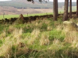
A ditch, running north northwest- south southeast, flanked by a bank on its eastern side. When recorded in August 2007 the bank was 4m wide and 1m high and the ditch was up to 4m wide and 1.2m deep. However, the ditch profile had obviously been recut relatively recently and the material cast on top of the bank, and also on to the west side creating a shallow bank. A trackway ran through the feature further damaging it. A description in the NMR archive also described the ditch running to the west at its southern end but this was not seen.
J.J. Hall, Trysor, 24 September 2007
coflein.gov.uk/en/sites/306133
You may be viewing yesterday's version of this page. To see the most up to date information please register for a free account.
")
Do not use the above information on other web sites or publications without permission of the contributor.
Nearby Images from Geograph Britain and Ireland:

©2009(licence)

©2009(licence)

©2013(licence)

©2012(licence)

©2025(licence)
The above images may not be of the site on this page, they are loaded from Geograph.
Please Submit an Image of this site or go out and take one for us!
Click here to see more info for this site
Nearby sites
Key: Red: member's photo, Blue: 3rd party photo, Yellow: other image, Green: no photo - please go there and take one, Grey: site destroyed
Download sites to:
KML (Google Earth)
GPX (GPS waypoints)
CSV (Garmin/Navman)
CSV (Excel)
To unlock full downloads you need to sign up as a Contributory Member. Otherwise downloads are limited to 50 sites.
Turn off the page maps and other distractions
Nearby sites listing. In the following links * = Image available
1.0km SE 131° Black Mixen Barrows* Round Barrow(s) (SO1960064300)
1.3km W 265° Cwm Bwch Barrows* Round Barrow(s) (SO175649)
2.6km SE 134° Whinyard Rocks Barrows* Round Barrow(s) (SO207631)
2.9km ESE 117° Bach Hill Barrows* Round Barrow(s) (SO21396365)
2.9km SE 144° Whimble Barrow* Round Barrow(s) (SO2050062600)
3.3km W 276° Shepherd's Tump* Round Barrow(s) (SO155654)
5.9km SW 230° Rhosdeglia Stone Standing Stone (Menhir) (SO1420661245)
6.1km ESE 114° Crossfield Lane Barrow (Kinnerton)* Round Barrow(s) (SO24356243)
6.1km ESE 111° Kinnerton* Standing Stones (SO24566274)
6.8km SSW 202° The Van* Round Barrow(s) (SO162587)
6.8km S 187° Llanfihangel Nant Melan* Standing Stone (Menhir) (SO1783258231)
7.0km SSW 205° Llanerch Stone Alignment Standing Stones (SO15775871)
7.0km SE 124° Four Stones Barrow Cemetary* Barrow Cemetery (SO24596091)
7.1km SE 125° Four Stones (Powys)* Stone Circle (SO24576080)
7.1km SSW 205° Llanerch Stone* Rock Art (SO15765858)
7.2km SE 127° Hindwell Cursus* Cursus (SO24496052)
7.3km ESE 120° Upper Ninepence barrow and Neolithic enclosure Round Barrow(s) (SO251613)
7.3km E 95° Beggar's Bush Barrow* Round Barrow(s) (SO26096417)
7.3km ESE 123° The Hindwell Stone* Standing Stone (Menhir) (SO24916093)
7.3km SE 132° Harpton Round Barrows* Round Barrow(s) (SO24225998)
7.4km SE 124° Hindwell Cursus* Cursus (SO24926074)
7.5km ENE 63° St Mary (Pilleth)* Holy Well or Sacred Spring (SO25636824)
7.6km ESE 122° Hindwell Farm 2* Round Barrow(s) (SO25226091)
7.6km SE 130° Knapp Mount Barrow* Barrow Cemetery (SO2458659975)
7.7km SW 216° Cwm Maerdy* Standing Stone (Menhir) (SO14205879)
View more nearby sites and additional images


 We would like to know more about this location. Please feel free to add a brief description and any relevant information in your own language.
 Wir möchten mehr über diese Stätte erfahren. Bitte zögern Sie nicht, eine kurze Beschreibung und relevante Informationen in Deutsch hinzuzufügen.
 Nous aimerions en savoir encore un peu sur les lieux. S'il vous plaît n'hesitez pas à ajouter une courte description et tous les renseignements pertinents dans votre propre langue.
 Quisieramos informarnos un poco más de las lugares. No dude en añadir una breve descripción y otros datos relevantes en su propio idioma.