<< Our Photo Pages >> Peatshiel Sike - Standing Stone (Menhir) in Scotland in Dumfries and Galloway
Submitted by markj99 on Monday, 18 January 2021 Page Views: 1957
Neolithic and Bronze AgeSite Name: Peatshiel Sike Alternative Name: BodesbeckCountry: Scotland
NOTE: This site is 5.5 km away from the location you searched for.
County: Dumfries and Galloway Type: Standing Stone (Menhir)
Nearest Town: Moffat
Map Ref: NT16190972
Latitude: 55.374282N Longitude: 3.324067W
Condition:
| 5 | Perfect |
| 4 | Almost Perfect |
| 3 | Reasonable but with some damage |
| 2 | Ruined but still recognisable as an ancient site |
| 1 | Pretty much destroyed, possibly visible as crop marks |
| 0 | No data. |
| -1 | Completely destroyed |
| 5 | Superb |
| 4 | Good |
| 3 | Ordinary |
| 2 | Not Good |
| 1 | Awful |
| 0 | No data. |
| 5 | Can be driven to, probably with disabled access |
| 4 | Short walk on a footpath |
| 3 | Requiring a bit more of a walk |
| 2 | A long walk |
| 1 | In the middle of nowhere, a nightmare to find |
| 0 | No data. |
| 5 | co-ordinates taken by GPS or official recorded co-ordinates |
| 4 | co-ordinates scaled from a detailed map |
| 3 | co-ordinates scaled from a bad map |
| 2 | co-ordinates of the nearest village |
| 1 | co-ordinates of the nearest town |
| 0 | no data |
Internal Links:
External Links:
")
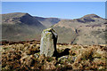
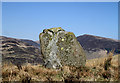
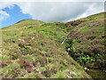
Canmore ID 71953 has listed the stone as prehistoric. The stone is erected close to Peatshiel Sike (sike being Scots for a small stream) at 358m above Sea Level. It is a squat stone reaching a rounded top at c. 5 feet with a 4x2 feet base.
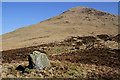
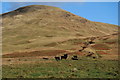
Directions: Peatshiel Sike can be accessed via a public path through Bodesbeck Farm heading E towards Bodesbeck Law. After c. 0.5 mile climbing the path will follow a stream (Peatshiel Sike) upwards. After you cross the stream about 150 yards later the path will veer S at NT 1602 0972. Continue E following Peatshiel Sike for c. 250 yards until the standing stone is visible about 25 yards S of the stream, on your right.
You may be viewing yesterday's version of this page. To see the most up to date information please register for a free account.
")
")
")
")
Do not use the above information on other web sites or publications without permission of the contributor.
Nearby Images from Geograph Britain and Ireland:
©2012(licence)
©2012(licence)
©2012(licence)
©2009(licence)
©2021(licence)
The above images may not be of the site on this page, they are loaded from Geograph.
Please Submit an Image of this site or go out and take one for us!
Click here to see more info for this site
Nearby sites
Key: Red: member's photo, Blue: 3rd party photo, Yellow: other image, Green: no photo - please go there and take one, Grey: site destroyed
Download sites to:
KML (Google Earth)
GPX (GPS waypoints)
CSV (Garmin/Navman)
CSV (Excel)
To unlock full downloads you need to sign up as a Contributory Member. Otherwise downloads are limited to 50 sites.
Turn off the page maps and other distractions
Nearby sites listing. In the following links * = Image available
7.4km WSW 249° Moffat Well* Holy Well or Sacred Spring (NT0924007200)
9.8km SW 232° Dyke Row* Stone Row / Alignment (NT0837503820)
10.6km N 353° Megget Stone* Standing Stone (Menhir) (NT1505720292)
11.3km NNW 346° Talla Linnfoots* Cairn (NT13622069)
11.3km SSW 210° Poldean menhir* Standing Stone (Menhir) (NT1037900011)
12.0km SSW 206° Chapman's Stone* Standing Stone (Menhir) (NY1078398986)
12.8km SE 138° Naga Stupa(cairn)* Modern Stone Circle etc (NT246001)
13.6km SSW 192° St Cuthbert's Church (Wamphray)* Ancient Cross (NY1307096462)
13.6km SSW 193° Wamphray Place* Misc. Earthwork (NY12829648)
14.0km SSW 197° Pumplaburn* Cairn (NY11869644)
14.0km S 188° Kirkhill* Stone Circle (NY1397895929)
15.4km NNW 327° Nether Dod* Stone Circle (NT08032279)
15.7km NNW 334° Giant's Stone (Scottish Borders)* Standing Stone (Menhir) (NT09532399)
15.7km NNW 334° Menzion* Standing Stones (NT0949023980)
16.1km SSW 197° Skip Knowe* Standing Stone (Menhir) (NY1118094430)
16.2km SE 143° Loupin' Stanes NW* Stone Circle (NY25709663)
16.2km SE 143° Loupin' Stanes SE* Stone Row / Alignment (NY25729660)
16.3km SW 227° Stiddrig* Cairn (NY04139877)
16.3km SE 145° Girdle Stanes* Stone Circle (NY2535196153)
16.6km SSE 147° Bessie's Hill Fort* Hillfort (NY2490095540)
16.7km SSE 147° Bessie's Hill Settlement Ancient Village or Settlement (NY249955)
17.1km SW 232° Lonnachie Rig Cairn (NY024995)
18.2km SSE 152° Over Rig* Misc. Earthwork (NY2455693475)
18.5km ENE 74° Black Rig Standing Stone (Menhir) (NT34151437)
18.6km SSE 154° Castle O'er Fort* Hillfort (NY2419092850)
View more nearby sites and additional images


 We would like to know more about this location. Please feel free to add a brief description and any relevant information in your own language.
 Wir möchten mehr über diese Stätte erfahren. Bitte zögern Sie nicht, eine kurze Beschreibung und relevante Informationen in Deutsch hinzuzufügen.
 Nous aimerions en savoir encore un peu sur les lieux. S'il vous plaît n'hesitez pas à ajouter une courte description et tous les renseignements pertinents dans votre propre langue.
 Quisieramos informarnos un poco más de las lugares. No dude en añadir una breve descripción y otros datos relevantes en su propio idioma.