<< Our Photo Pages >> Tulach Beag - Broch or Nuraghe in Scotland in Caithness
Submitted by SolarMegalith on Sunday, 05 December 2010 Page Views: 2531
Iron Age and Later PrehistorySite Name: Tulach BeagCountry: Scotland County: Caithness Type: Broch or Nuraghe
Nearest Town: Halkirk Nearest Village: Tormsdale
Map Ref: ND14594980
Latitude: 58.428152N Longitude: 3.464182W
Condition:
| 5 | Perfect |
| 4 | Almost Perfect |
| 3 | Reasonable but with some damage |
| 2 | Ruined but still recognisable as an ancient site |
| 1 | Pretty much destroyed, possibly visible as crop marks |
| 0 | No data. |
| -1 | Completely destroyed |
| 5 | Superb |
| 4 | Good |
| 3 | Ordinary |
| 2 | Not Good |
| 1 | Awful |
| 0 | No data. |
| 5 | Can be driven to, probably with disabled access |
| 4 | Short walk on a footpath |
| 3 | Requiring a bit more of a walk |
| 2 | A long walk |
| 1 | In the middle of nowhere, a nightmare to find |
| 0 | No data. |
| 5 | co-ordinates taken by GPS or official recorded co-ordinates |
| 4 | co-ordinates scaled from a detailed map |
| 3 | co-ordinates scaled from a bad map |
| 2 | co-ordinates of the nearest village |
| 1 | co-ordinates of the nearest town |
| 0 | no data |
Internal Links:
External Links:
")
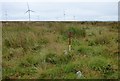
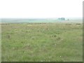
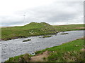
Remains of broch preserved as a mound with visible stones. Remains of the internal chamber and entrance are still distinguishable.
You may be viewing yesterday's version of this page. To see the most up to date information please register for a free account.
")
Do not use the above information on other web sites or publications without permission of the contributor.
Nearby Images from Geograph Britain and Ireland:
©2018(licence)

©2025(licence)
©2009(licence)

©2024(licence)
©2011(licence)
The above images may not be of the site on this page, they are loaded from Geograph.
Please Submit an Image of this site or go out and take one for us!
Click here to see more info for this site
Nearby sites
Key: Red: member's photo, Blue: 3rd party photo, Yellow: other image, Green: no photo - please go there and take one, Grey: site destroyed
Download sites to:
KML (Google Earth)
GPX (GPS waypoints)
CSV (Garmin/Navman)
CSV (Excel)
To unlock full downloads you need to sign up as a Contributory Member. Otherwise downloads are limited to 50 sites.
Turn off the page maps and other distractions
Nearby sites listing. In the following links * = Image available
247m ESE 103° Tormsdale Stone Rows* Multiple Stone Rows / Avenue (ND14834974)
476m SE 146° Tulach Mor* Broch or Nuraghe (ND14854940)
1.8km NW 313° Cairn Na Mairg* Broch or Nuraghe (ND13315103)
2.6km NW 321° Tulach Buaile A' Chroic* Broch or Nuraghe (ND12995186)
2.6km WSW 240° Dirlot (North)* Multiple Stone Rows / Avenue (ND1228048560)
2.8km WSW 238° Dirlot (South)* Stone Row / Alignment (ND1220748411)
2.8km NE 50° Achkeepster Broch or Nuraghe (ND16805158)
2.8km NW 320° Tulach Lochain Braiseal Broch or Nuraghe (ND12825203)
2.8km NW 322° Tulach An Fhuarain Broch or Nuraghe (ND12875208)
3.1km E 99° Halsary Standing Stone Standing Stone (Menhir) (ND17644923)
3.1km E 91° Halsary Standing Stone North Standing Stone (Menhir) (ND1774149665)
4.6km NE 40° Knockglass Broch Broch or Nuraghe (ND17615329)
5.0km NNE 29° Spittal Quarry* Modern Stone Circle etc (ND171541)
5.4km NNE 32° Spittal Farm Broch or Nuraghe (ND17565438)
5.6km NNW 343° Achies West* Broch or Nuraghe (ND13055522)
5.8km SSE 147° Rangag* Standing Stone (Menhir) (ND17684488)
5.9km N 353° Achies East* Broch or Nuraghe (ND14005565)
5.9km N 358° Achanarras Stone Circle and Cairn* Stone Circle (ND1453255749)
6.0km SE 140° Rangag East* Standing Stone (Menhir) (ND18384512)
6.3km NW 318° Achingoul Broch or Nuraghe (ND10475463)
7.4km SE 137° Ballachly Broch Broch or Nuraghe (ND19564423)
7.9km ENE 75° Acharole* Stone Circle (ND22335166)
8.4km ENE 76° Bail of A' Chairn* Broch or Nuraghe (ND22815171)
8.6km NE 41° Bridge of Dunn Broch Broch or Nuraghe (ND20415613)
8.8km SSE 156° Greystell Castle* Broch or Nuraghe (ND17954167)
View more nearby sites and additional images


 We would like to know more about this location. Please feel free to add a brief description and any relevant information in your own language.
 Wir möchten mehr über diese Stätte erfahren. Bitte zögern Sie nicht, eine kurze Beschreibung und relevante Informationen in Deutsch hinzuzufügen.
 Nous aimerions en savoir encore un peu sur les lieux. S'il vous plaît n'hesitez pas à ajouter une courte description et tous les renseignements pertinents dans votre propre langue.
 Quisieramos informarnos un poco más de las lugares. No dude en añadir una breve descripción y otros datos relevantes en su propio idioma.