<< Our Photo Pages >> Cairn Liath - Chambered Cairn in Scotland in Caithness
Submitted by cosmic on Sunday, 07 October 2007 Page Views: 5135
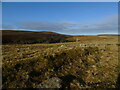
Neolithic and Bronze AgeSite Name: Cairn Liath Alternative Name: LoedebestCountry: Scotland County: Caithness Type: Chambered Cairn
Nearest Village: Dunbeath
Map Ref: ND14033205
Latitude: 58.268676N Longitude: 3.467142W
Condition:
| 5 | Perfect |
| 4 | Almost Perfect |
| 3 | Reasonable but with some damage |
| 2 | Ruined but still recognisable as an ancient site |
| 1 | Pretty much destroyed, possibly visible as crop marks |
| 0 | No data. |
| -1 | Completely destroyed |
| 5 | Superb |
| 4 | Good |
| 3 | Ordinary |
| 2 | Not Good |
| 1 | Awful |
| 0 | No data. |
| 5 | Can be driven to, probably with disabled access |
| 4 | Short walk on a footpath |
| 3 | Requiring a bit more of a walk |
| 2 | A long walk |
| 1 | In the middle of nowhere, a nightmare to find |
| 0 | No data. |
| 5 | co-ordinates taken by GPS or official recorded co-ordinates |
| 4 | co-ordinates scaled from a detailed map |
| 3 | co-ordinates scaled from a bad map |
| 2 | co-ordinates of the nearest village |
| 1 | co-ordinates of the nearest town |
| 0 | no data |
Internal Links:
External Links:
")
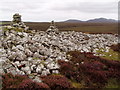
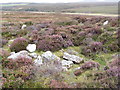
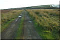
Just off the track going up to Dunbeath Cemetery lies the remains of this horned cairn with another cairn nearby.
You may be viewing yesterday's version of this page. To see the most up to date information please register for a free account.
")
Do not use the above information on other web sites or publications without permission of the contributor.
Nearby Images from Geograph Britain and Ireland:
©2008(licence)
©2008(licence)
©2010(licence)
©2018(licence)
©2023(licence)
The above images may not be of the site on this page, they are loaded from Geograph.
Please Submit an Image of this site or go out and take one for us!
Click here to see more info for this site
Nearby sites
Key: Red: member's photo, Blue: 3rd party photo, Yellow: other image, Green: no photo - please go there and take one, Grey: site destroyed
Download sites to:
KML (Google Earth)
GPX (GPS waypoints)
CSV (Garmin/Navman)
CSV (Excel)
To unlock full downloads you need to sign up as a Contributory Member. Otherwise downloads are limited to 50 sites.
Turn off the page maps and other distractions
Nearby sites listing. In the following links * = Image available
50m NW 322° Loedebest* Chambered Cairn (ND14003209)
691m WNW 289° Loedebest West* Chambered Cairn (ND13383229)
1.3km ESE 122° Bridge of Rhemullen Broch or Nuraghe (ND15083135)
1.4km NW 317° Cnoc Na Maranaich* Chambered Cairn (ND131331)
1.6km S 191° Achorn Broch or Nuraghe (ND13693050)
1.7km SE 128° Dunbrae Broch Broch or Nuraghe (ND15323098)
2.0km E 88° Achnagoul* Standing Stone (Menhir) (ND16023207)
2.0km ENE 74° Achnagoul circle Stone Circle (ND16013256)
2.2km SE 137° Dunbeath* Broch or Nuraghe (ND155304)
2.4km SE 135° Ballachly Carved Stones* Early Christian Sculptured Stone (ND157303)
2.7km NNE 34° Houstry* Standing Stone (Menhir) (ND156343)
2.7km SW 229° Bad Nan Glac Ancient Village or Settlement (ND119303)
3.4km NNE 20° Tiantulloch* Broch or Nuraghe (ND15243522)
3.6km E 81° Latheronwheel Mains Broch or Nuraghe (ND17623251)
3.7km ESE 104° Knockinnon* Broch or Nuraghe (ND17643105)
4.1km ENE 64° Smerral Broch or Nuraghe (ND17803379)
4.3km SSW 213° Burg Ruadh Broch or Nuraghe (ND11602852)
4.4km E 94° Latheronwheel Chambered Cairn Chambered Cairn (ND18443168)
4.7km ENE 75° Latheronwheel Stone Circle (ND186332)
5.0km W 281° Bouilag* Stone Circle (ND09123309)
5.1km NE 52° Guidebest* Stone Circle (ND181351)
5.2km SSW 197° Upper Borgue Broch Broch or Nuraghe (ND12432708)
5.6km SSW 193° Upper Borgue Standing Stone* Standing Stone (Menhir) (ND12632665)
5.8km S 191° The Two Dogs* Standing Stone (Menhir) (ND1281026389)
6.0km ENE 75° Latheron 2* Class I Pictish Symbol Stone (ND19903343)
View more nearby sites and additional images


 We would like to know more about this location. Please feel free to add a brief description and any relevant information in your own language.
 Wir möchten mehr über diese Stätte erfahren. Bitte zögern Sie nicht, eine kurze Beschreibung und relevante Informationen in Deutsch hinzuzufügen.
 Nous aimerions en savoir encore un peu sur les lieux. S'il vous plaît n'hesitez pas à ajouter une courte description et tous les renseignements pertinents dans votre propre langue.
 Quisieramos informarnos un poco más de las lugares. No dude en añadir una breve descripción y otros datos relevantes en su propio idioma.