<< Other Photo Pages >> Maen Cattwg - Rock Art in Wales in Mid Glamorgan
Submitted by coldrum on Friday, 13 July 2007 Page Views: 10466
Rock ArtSite Name: Maen Cattwg Alternative Name: Maen Catwg; Gelli-Gaer CarvingCountry: Wales
NOTE: This site is 0.4 km away from the location you searched for.
County: Mid Glamorgan Type: Rock Art
Nearest Town: Gelligaer
Map Ref: ST12709742
Latitude: 51.668747N Longitude: 3.263746W
Condition:
| 5 | Perfect |
| 4 | Almost Perfect |
| 3 | Reasonable but with some damage |
| 2 | Ruined but still recognisable as an ancient site |
| 1 | Pretty much destroyed, possibly visible as crop marks |
| 0 | No data. |
| -1 | Completely destroyed |
| 5 | Superb |
| 4 | Good |
| 3 | Ordinary |
| 2 | Not Good |
| 1 | Awful |
| 0 | No data. |
| 5 | Can be driven to, probably with disabled access |
| 4 | Short walk on a footpath |
| 3 | Requiring a bit more of a walk |
| 2 | A long walk |
| 1 | In the middle of nowhere, a nightmare to find |
| 0 | No data. |
| 5 | co-ordinates taken by GPS or official recorded co-ordinates |
| 4 | co-ordinates scaled from a detailed map |
| 3 | co-ordinates scaled from a bad map |
| 2 | co-ordinates of the nearest village |
| 1 | co-ordinates of the nearest town |
| 0 | no data |
Internal Links:
External Links:
I have visited· I would like to visit
trystan_hughes visited on 6th Nov 2015 - their rating: Cond: 3 Amb: 3 Access: 4
druid visited - their rating: Cond: 3 Amb: 2 Access: 2
druid visited - their rating: Cond: 3 Amb: 2 Access: 3
Average ratings for this site from all visit loggers: Condition: 3 Ambience: 2.33 Access: 3
Directions: Park at the Cross Inn, Heol Adam, Hengoed, Gelligaer, Glamorgan. Walk about a hundred yards up Heol Adam until you pass a squat red building on your right. The stile is on your left. Cross the field to the gate into the second field. Visible on your right is the stone, in the middle of that field.
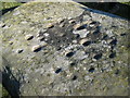
You'll notice that there are stones underneath the main stone. Perhaps one day there'll be an excavation there, to see if it really is the capstone of a cromlech. In the meantime, mind the horses ( see video ).
Text by Laurence Peddle (Laurencewithau)
For more information see Coflein site no. 93097, an extract of which reads: "A roughly rectangular prostrate stone, 2.6m by 1.7m and 0.6m thick. There are 33-50 cup-marks on the upper surface of the stone, which has been suggested to have been the capstone of a collapsed megalithic chamber ... Details of a second carved stone bearing peck-marked decoration, located close to Maen Catwg in 1990 ... The rectangular stone bore an arc of 6 small peck marks towards one pointed corner of its upper surface, associated with a line of 3 peck marks extending from the arc."
The Northern Antiquarian (TNA) also features a page for this site - see their entry for Maen Cattwg, Gelligaer, Glamorganshire, which also gives directions for finding the site from Galligaer, together with a brief archaeology & history.
Note: Have you visited this site? Do you have any photographs or information to add?
You may be viewing yesterday's version of this page. To see the most up to date information please register for a free account.
Do not use the above information on other web sites or publications without permission of the contributor.
Nearby Images from Geograph Britain and Ireland:
©2010(licence)
©2012(licence)
©2008(licence)
©2023(licence)
©2018(licence)
The above images may not be of the site on this page, they are loaded from Geograph.
Please Submit an Image of this site or go out and take one for us!
Click here to see more info for this site
Nearby sites
Key: Red: member's photo, Blue: 3rd party photo, Yellow: other image, Green: no photo - please go there and take one, Grey: site destroyed
Download sites to:
KML (Google Earth)
GPX (GPS waypoints)
CSV (Garmin/Navman)
CSV (Excel)
To unlock full downloads you need to sign up as a Contributory Member. Otherwise downloads are limited to 50 sites.
Turn off the page maps and other distractions
Nearby sites listing. In the following links * = Image available
1.7km NNE 12° Gelligaer Common Cairn Cairn (ST131991)
3.7km WNW 297° Coed Cae Cairns and field system Cairn (ST094992)
3.9km NNW 335° Cefn Gelligaer Cross Dyke Misc. Earthwork (SO111010)
3.9km NNW 335° Cefn Gelligaer Cairn Cairn (SO111010)
4.4km WNW 288° Tir-Cook Cairn Cairn (ST085989)
4.9km NNW 331° Coed Yr Hendre House Platform Ancient Village or Settlement (SO104018)
4.9km NE 56° St Sannan's Well* Holy Well or Sacred Spring (SO16860011)
5.0km WNW 299° Mynydd Y Capel Standing Stone* Standing Stone (Menhir) (ST084999)
5.0km WNW 299° Mynydd Y Capel Cairns Cairn (ST084999)
5.1km WNW 300° Mynydd Y Capel Cairnfield* Cairn (SO0835100032)
5.3km WNW 301° Mynydd Y Capel Cairn Cemetry Cairn (SO0822200245)
5.5km SSW 198° Ffos-yr-Haidal 1, Mynydd Eglwysilan* Rock Art (ST10899224)
5.6km SE 128° Stone near Tyle-Gwyn, Wyllie Standing Stone (Menhir) (ST17069386)
5.6km N 7° New Tredegar House Platforms Ancient Village or Settlement (SO135030)
5.7km N 1° New Tredegar Cairn Cairn (SO129031)
5.8km S 177° Waun Deiliaid Ring Cairn (ST12939162)
5.8km SSW 201° Carneddi Llwydion* Round Cairn (ST105920)
5.9km N 3° New Tredeger Cairns Cairn (SO131033)
6.2km NNW 337° Blaenllwynau, Cairn I Cairn (SO10350316)
6.2km NNW 337° Blaenllwynau, Cairn II Cairn (SO10340318)
6.3km NNW 332° Gelligaer Common Round Barrow(s) (SO09810305)
6.3km NNW 336° Pen Garnbugail Cairn (SO10250328)
6.4km NNW 338° Gelligaer Common Standing Stone* Standing Stone (Menhir) (SO10340340)
6.4km S 171° The Bryn Earthwork Ring Cairn (ST13619105)
6.5km SE 137° Mynydd Bach Cairn 2* Round Barrow(s) (ST17019259)
View more nearby sites and additional images


 We would like to know more about this location. Please feel free to add a brief description and any relevant information in your own language.
 Wir möchten mehr über diese Stätte erfahren. Bitte zögern Sie nicht, eine kurze Beschreibung und relevante Informationen in Deutsch hinzuzufügen.
 Nous aimerions en savoir encore un peu sur les lieux. S'il vous plaît n'hesitez pas à ajouter une courte description et tous les renseignements pertinents dans votre propre langue.
 Quisieramos informarnos un poco más de las lugares. No dude en añadir una breve descripción y otros datos relevantes en su propio idioma.