<< Our Photo Pages >> Maen Huail - Standing Stone (Menhir) in Wales in Denbighshire
Submitted by TimPrevett on Monday, 23 October 2006 Page Views: 8136
Neolithic and Bronze AgeSite Name: Maen HuailCountry: Wales County: Denbighshire Type: Standing Stone (Menhir)
Nearest Town: Ruthin
Map Ref: SJ1237558279
Latitude: 53.114468N Longitude: 3.310597W
Condition:
| 5 | Perfect |
| 4 | Almost Perfect |
| 3 | Reasonable but with some damage |
| 2 | Ruined but still recognisable as an ancient site |
| 1 | Pretty much destroyed, possibly visible as crop marks |
| 0 | No data. |
| -1 | Completely destroyed |
| 5 | Superb |
| 4 | Good |
| 3 | Ordinary |
| 2 | Not Good |
| 1 | Awful |
| 0 | No data. |
| 5 | Can be driven to, probably with disabled access |
| 4 | Short walk on a footpath |
| 3 | Requiring a bit more of a walk |
| 2 | A long walk |
| 1 | In the middle of nowhere, a nightmare to find |
| 0 | No data. |
| 5 | co-ordinates taken by GPS or official recorded co-ordinates |
| 4 | co-ordinates scaled from a detailed map |
| 3 | co-ordinates scaled from a bad map |
| 2 | co-ordinates of the nearest village |
| 1 | co-ordinates of the nearest town |
| 0 | no data |
Internal Links:
External Links:
I have visited· I would like to visit
TimPrevett has visited here
")
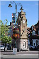
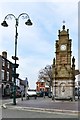
Not known for sure if it is prehistoric, but this limestone chunk is reputed to be that upon which King Arthur beheaded Gildas' brother. Outside Barclays bank in the town centre, next to the roundabout.
This limestone block is recorded as Coflein NPRN 306840. Coflein adds that this stone may well be a market stone, civic stone, or a preaching stone.
The Journal of Antiquities also includes an entry for Maen Huail, Ruthin, Denbighshire, Wales, which includes a drawing of the stone, background information about the warrior who was beheaded (Huail), and a list of reference sources for more information.
You may be viewing yesterday's version of this page. To see the most up to date information please register for a free account.
")
Do not use the above information on other web sites or publications without permission of the contributor.
coldrum has found this location on Google Street View:
Nearby Images from Geograph Britain and Ireland:
©2013(licence)
©2019(licence)
©2021(licence)

©2024(licence)

©2013(licence)
The above images may not be of the site on this page, they are loaded from Geograph.
Please Submit an Image of this site or go out and take one for us!
Click here to see more info for this site
Nearby sites
Key: Red: member's photo, Blue: 3rd party photo, Yellow: other image, Green: no photo - please go there and take one, Grey: site destroyed
Download sites to:
KML (Google Earth)
GPX (GPS waypoints)
CSV (Garmin/Navman)
CSV (Excel)
To unlock full downloads you need to sign up as a Contributory Member. Otherwise downloads are limited to 50 sites.
Turn off the page maps and other distractions
Nearby sites listing. In the following links * = Image available
485m S 188° Gorsedd Stones Ruthin, Modern Eisteddfod Stone Circle* Modern Stone Circle etc (SJ123578)
1.7km ESE 107° St Meugan's Cross Early Christian Sculptured Stone (SJ14005774)
2.3km SE 130° Cefn Coch Tumulus Round Barrow(s) (SJ141568)
3.6km SW 221° Carreg Clocaenog* Standing Stone (Menhir) (SJ0991755605)
3.9km SSW 206° Pen-Y-Gaer (Efenechtyd) Hillfort (SJ10585484)
4.3km NE 34° Moel-y-Gaer (Loggerheads)* Hillfort (SJ14866175)
4.3km ENE 64° Foel Fenlli* Hillfort (SJ1632060080)
4.7km NE 50° Coed Clwyd Cairns* Burial Chamber or Dolmen (SJ16026127)
4.7km NE 46° Bwlch Penbarra Marker Stone (SJ1584661500)
4.9km E 97° Moel Gwy Tumulus* Round Cairn (SJ172576)
5.1km ESE 118° Llanarmon Yn Lal Burial Mounds* Round Barrow(s) (SJ168558)
5.5km ESE 119° Moel Y Plas Tumulus* Round Cairn (SJ171555)
5.6km N 8° Ffynnon Cynhafal* Holy Well or Sacred Spring (SJ133638)
6.7km NW 318° St Dyfnog's Well* Holy Well or Sacred Spring (SJ0798263347)
6.7km SE 137° Moel Y Waun Round Cairn North* Round Cairn (SJ169533)
6.8km SE 137° Moel Y Waun Round Cairn South* Round Cairn (SJ169532)
7.1km ESE 106° Llanarmon Yn Ial (St Garmon)* Stone Circle (SJ1912656153)
7.2km ESE 105° Llanarmon Cave Cave or Rock Shelter (SJ1933956265)
7.4km ESE 107° Tomen Y Faerdre Standing Stone* Standing Stone (Menhir) (SJ194560)
7.4km ESE 108° Cefn Canol* Round Barrow(s) (SJ194559)
7.4km E 81° Lynx Cave Cave or Rock Shelter (SJ19765931)
7.7km ENE 72° Big Covert Cave or Rock Shelter (SJ19796055)
7.9km SE 125° Perthi Chwarae Farm Cave 1 Cave or Rock Shelter (SJ18795363)
8.0km SE 125° Rhos Isaf Cave* Cave or Rock Shelter (SJ18845355)
8.0km NNE 14° Moel Arthur* Hillfort (SJ1453266040)
View more nearby sites and additional images


 We would like to know more about this location. Please feel free to add a brief description and any relevant information in your own language.
 Wir möchten mehr über diese Stätte erfahren. Bitte zögern Sie nicht, eine kurze Beschreibung und relevante Informationen in Deutsch hinzuzufügen.
 Nous aimerions en savoir encore un peu sur les lieux. S'il vous plaît n'hesitez pas à ajouter une courte description et tous les renseignements pertinents dans votre propre langue.
 Quisieramos informarnos un poco más de las lugares. No dude en añadir una breve descripción y otros datos relevantes en su propio idioma.