<< Our Photo Pages >> Hilton Of Moncrieffe - Standing Stone (Menhir) in Scotland in Perth and Kinross
Submitted by BigSweetie on Thursday, 25 March 2004 Page Views: 6865
Neolithic and Bronze AgeSite Name: Hilton Of MoncrieffeCountry: Scotland County: Perth and Kinross Type: Standing Stone (Menhir)
Nearest Town: Perth
Map Ref: NO11062067 Landranger Map Number: 53
Latitude: 56.369942N Longitude: 3.441453W
Condition:
| 5 | Perfect |
| 4 | Almost Perfect |
| 3 | Reasonable but with some damage |
| 2 | Ruined but still recognisable as an ancient site |
| 1 | Pretty much destroyed, possibly visible as crop marks |
| 0 | No data. |
| -1 | Completely destroyed |
| 5 | Superb |
| 4 | Good |
| 3 | Ordinary |
| 2 | Not Good |
| 1 | Awful |
| 0 | No data. |
| 5 | Can be driven to, probably with disabled access |
| 4 | Short walk on a footpath |
| 3 | Requiring a bit more of a walk |
| 2 | A long walk |
| 1 | In the middle of nowhere, a nightmare to find |
| 0 | No data. |
| 5 | co-ordinates taken by GPS or official recorded co-ordinates |
| 4 | co-ordinates scaled from a detailed map |
| 3 | co-ordinates scaled from a bad map |
| 2 | co-ordinates of the nearest village |
| 1 | co-ordinates of the nearest town |
| 0 | no data |
Be the first person to rate this site - see the 'Contribute!' box in the right hand menu.
Internal Links:
External Links:
")
Have you visited this site? Please add a comment below.
You may be viewing yesterday's version of this page. To see the most up to date information please register for a free account.
Do not use the above information on other web sites or publications without permission of the contributor.
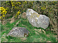
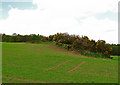
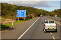
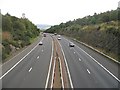
Nearby Images from Geograph Britain and Ireland:
©2011(licence)
©2011(licence)
©2019(licence)
©2010(licence)
©2015(licence)
The above images may not be of the site on this page, they are loaded from Geograph.
Please Submit an Image of this site or go out and take one for us!
Click here to see more info for this site
Nearby sites
Key: Red: member's photo, Blue: 3rd party photo, Yellow: other image, Green: no photo - please go there and take one, Grey: site destroyed
Download sites to:
KML (Google Earth)
GPX (GPS waypoints)
CSV (Garmin/Navman)
CSV (Excel)
To unlock full downloads you need to sign up as a Contributory Member. Otherwise downloads are limited to 50 sites.
Turn off the page maps and other distractions
Nearby sites listing. In the following links * = Image available
233m SW 222° Kirkton Hill Stone Circle (NO109205)
970m E 79° Craigclowan Standing Stone (Menhir) (NO12022083)
1.3km W 265° Callarfountain* Standing Stone (Menhir) (NO09752058)
2.2km ESE 110° Moncreiffe Hill* Hillfort (NO13131988)
2.3km NNE 23° South Inch, Perth Standing Stone (Menhir) (NO12002274)
2.5km ESE 121° Moncrieffe Timber Circle (NO132193)
2.6km ESE 104° Moredun Top Hillfort (NO13621999)
2.9km ESE 117° Moncrieffe* Stone Circle (NO13601933)
2.9km ESE 116° Boar Stone* Class III Pictish Cross Slab (NO13661933)
2.9km ESE 116° Gask House Class II Pictish Symbol Stone (NO13661933)
3.2km NNE 14° Perth Museum and Art Gallery* Museum (NO119238)
3.2km NNE 14° Inchyra* Class I Pictish Symbol Stone (NO119238)
3.9km NNE 24° Murray Royal Hospital* Standing Stone (Menhir) (NO127242)
5.3km NNW 332° Hunting Tower Cursus (NO087254)
5.4km NW 323° Mains Of Huntingtower Stone Circle (NO079251)
5.9km NW 314° Huntingtower Cairn (NO069249)
6.2km NNE 20° Sandy Road East Stone Circle (NO13282646)
6.2km NNE 20° Sandy Road* Stone Circle (NO1327526463)
6.4km WSW 239° Forteviot Dagger Burial* Cist (NO055175)
6.6km WSW 240° St Andrew's Church (Forteviot) Class III Pictish Cross Slab (NO052175)
6.6km WSW 241° Forteviot Cross* Sculptured Stone (NO0518017527)
6.9km SW 236° Forteviot Timber Circle (NO053169)
6.9km NE 35° Murrayshall* Standing Stone (Menhir) (NO1519926265)
7.1km NNW 345° Whinny Hill Round Cairn (NO093276)
7.3km N 2° Scone Cursus Cursus (NO11532797)
View more nearby sites and additional images


 We would like to know more about this location. Please feel free to add a brief description and any relevant information in your own language.
 Wir möchten mehr über diese Stätte erfahren. Bitte zögern Sie nicht, eine kurze Beschreibung und relevante Informationen in Deutsch hinzuzufügen.
 Nous aimerions en savoir encore un peu sur les lieux. S'il vous plaît n'hesitez pas à ajouter une courte description et tous les renseignements pertinents dans votre propre langue.
 Quisieramos informarnos un poco más de las lugares. No dude en añadir una breve descripción y otros datos relevantes en su propio idioma.