


<< Our Photo Pages >> Patervan Settlement - Ancient Village or Settlement in Scotland in Scottish Borders
Submitted by Anne T on Monday, 23 July 2018 Page Views: 1708
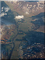
Multi-periodSite Name: Patervan Settlement Alternative Name: Polmood Hill; River Tweed SettlementCountry: Scotland
NOTE: This site is 2.5 km away from the location you searched for.
County: Scottish Borders Type: Ancient Village or Settlement
Nearest Town: Moffat Nearest Village: Tweedsmuir / Drumelzier
Map Ref: NT11252854
Latitude: 55.542469N Longitude: 3.408006W
Condition:
| 5 | Perfect |
| 4 | Almost Perfect |
| 3 | Reasonable but with some damage |
| 2 | Ruined but still recognisable as an ancient site |
| 1 | Pretty much destroyed, possibly visible as crop marks |
| 0 | No data. |
| -1 | Completely destroyed |
| 5 | Superb |
| 4 | Good |
| 3 | Ordinary |
| 2 | Not Good |
| 1 | Awful |
| 0 | No data. |
| 5 | Can be driven to, probably with disabled access |
| 4 | Short walk on a footpath |
| 3 | Requiring a bit more of a walk |
| 2 | A long walk |
| 1 | In the middle of nowhere, a nightmare to find |
| 0 | No data. |
| 5 | co-ordinates taken by GPS or official recorded co-ordinates |
| 4 | co-ordinates scaled from a detailed map |
| 3 | co-ordinates scaled from a bad map |
| 2 | co-ordinates of the nearest village |
| 1 | co-ordinates of the nearest town |
| 0 | no data |
Internal Links:
External Links:
I have visited· I would like to visit
Anne T saw from a distance on 12th Jul 2018 - their rating: Cond: 2 Amb: 3 Access: 4 Patervan/Polmood Settlement, just west of Patervan Farm Cottage: After the Meggat Stone, we stopped off at Henderland Chapel (aka Chapel Knowe and Cockburn’s Tombstone) at NT 23112 23414, which was well worth a look, but too modern for the Portal!
This settlement is (almost!) easily reached. We parked at a layby on the western side of the A701, just north of the entrance to Patervan farm at NT 10850 28570. To think we’ve driven this way many, many times before over the years, but didn’t even consider exploring this area.
We crossed over the River Tweed (with its river monitoring station) via the robust bridge, and followed the track up to Patervan farm. We passed the cottage on our right hand side. then diverted on the footpath which led into the field just before the sign for ‘Patervan Steading’. The gate into the field on the other side of the track at this point was chained and padlocked, along with an electrified fence. We clambered over the wooden fence next to the gate, only to be confronted by another chained and locked gate. As we wanted to get on and climb up to the hillfort and another, larger settlement, we decided to hedge out bets and simply looked over the stone wall, deciding if there was time on the way back, to hop over and take a closer look (but we ran out of time).
I was really surprised to find so many ancient sites, almost an entire archaeological landscape, in a relatively small area. Worth investigating again, although not hugely, hugely exciting.
")
This settlement is recorded as Canmore ID 49752, which tells us it lies on the north western slopes of Polmood Hill, 180 feet above the eastern bank of the River Tweed. It is oval in shape, measuring 120 feet by 90 feet, with an outer wall of 8ft thick. Several of the facing stones within the wall, particularly on its western end, remain in situ.
The settlement could be relatively easily reached by following the track along to Patervan Farm and Patervan Steading, moving onto the track at NT 11159 28595 that leads into the fields and along the side of the hill, parallel to the River Tweed. However, the gate onto this track was very securely padlocked with an electrified fence either side, so we cautiously climbed over, expecting to be challenged by the farmer at any moment.
Immediately beyond this gate is a gate into another field, at NT 11189 28570. This gate was also securely chained and padlocked, so as there were further settlements and a fort higher up the hill that we wanted to investigate, we contented ourselves with taking photographs over the stone wall.
On reading the Canmore record later, this site was apparently only discovered in 1957 during a Survey of Marginal Land: "The interior, which falls as much as 22ft from SE to NW contains three certain house-platforms, the largest measuring 28ft in diameter, and faint traces of others too indefinite to plan."
You may be viewing yesterday's version of this page. To see the most up to date information please register for a free account.
")
")
")
Do not use the above information on other web sites or publications without permission of the contributor.
Nearby Images from Geograph Britain and Ireland:
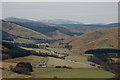
©2011(licence)
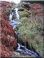
©2007(licence)
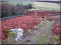
©2007(licence)
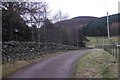
©2017(licence)
©2018(licence)
The above images may not be of the site on this page, they are loaded from Geograph.
Please Submit an Image of this site or go out and take one for us!
Click here to see more info for this site
Nearby sites
Key: Red: member's photo, Blue: 3rd party photo, Yellow: other image, Green: no photo - please go there and take one, Grey: site destroyed
Download sites to:
KML (Google Earth)
GPX (GPS waypoints)
CSV (Garmin/Navman)
CSV (Excel)
To unlock full downloads you need to sign up as a Contributory Member. Otherwise downloads are limited to 50 sites.
Turn off the page maps and other distractions
Nearby sites listing. In the following links * = Image available
315m NNW 348° Patervan Cairn, Buildings & Mound* Cairn (NT11192885)
769m NE 36° Norman's Castle* Stone Fort or Dun (NT11722915)
875m NNE 24° Laigh Hill (Tweeddale)* Ancient Village or Settlement (NT11632933)
2.8km NNE 18° Woodend, Mossfennan Farm* Cist (NT12173124)
4.9km SSW 200° Giant's Stone (Scottish Borders)* Standing Stone (Menhir) (NT09532399)
4.9km SSW 200° Menzion* Standing Stones (NT0949023980)
5.1km N 1° Rachan Hill Henge (NT11423363)
5.5km N 2° Piper's Stone Standing Stone (Menhir) (NT11533400)
5.6km NW 326° Knowe Kniffling* Hillfort (NT08163323)
5.7km NNW 330° Mill Rings Misc. Earthwork (NT08493357)
6.0km N 353° Whitslade Hill Burnt Mound Artificial Mound (NT10603447)
6.6km NNE 25° Tinnis Castle* Hillfort (NT14153444)
6.6km SSW 208° Nether Dod* Stone Circle (NT08032279)
6.8km N 357° Helm End Hillfort (NT10983532)
6.9km N 11° Dreva Craig* Hillfort (NT12673533)
7.0km N 9° Dreva Craig* Standing Stone (Menhir) (NT12453545)
7.2km NNE 12° Dreva Hill West (Broughton)* Ancient Village or Settlement (NT12923553)
7.2km E 84° Nethertown Stone Circle (NT185291)
7.4km NNW 335° Parkgatestone Hill Ancient Village or Settlement (NT08293529)
7.4km NNE 20° Drumelzier Haugh* Standing Stone (Menhir) (NT13933542)
7.5km NW 317° Mitchelhill Rings Hillfort (NT06283417)
7.8km NNW 331° Cleuch Hill* Cairn (NT07573546)
8.2km SSE 162° Talla Linnfoots* Cairn (NT13622069)
8.4km NNE 31° Altar Stone, Stobo* Standing Stone (Menhir) (NT15703573)
8.5km WNW 294° Nisbet* Hillfort (NT03543216)
View more nearby sites and additional images


 We would like to know more about this location. Please feel free to add a brief description and any relevant information in your own language.
 Wir möchten mehr über diese Stätte erfahren. Bitte zögern Sie nicht, eine kurze Beschreibung und relevante Informationen in Deutsch hinzuzufügen.
 Nous aimerions en savoir encore un peu sur les lieux. S'il vous plaît n'hesitez pas à ajouter une courte description et tous les renseignements pertinents dans votre propre langue.
 Quisieramos informarnos un poco más de las lugares. No dude en añadir una breve descripción y otros datos relevantes en su propio idioma.